
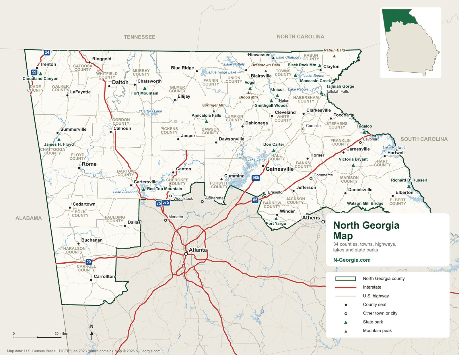
This map covers all of North Georgia, from Lookout Mountain and Cloudland Canyon in the northwest corner to Lake Hartwell on the South Carolina line. It shows every county seat, the interstates and U.S. highways that connect them, the big reservoirs, all 17 state parks in the region and four well-known mountain peaks. Atlanta, Marietta, Alpharetta and Athens are marked just outside the region so you can judge driving distances from the city.
Click the map for the full-size version, or grab the printable PDF for the car. Cell coverage drops out on plenty of mountain roads, so a paper copy is worth having.
What Counts as North Georgia?
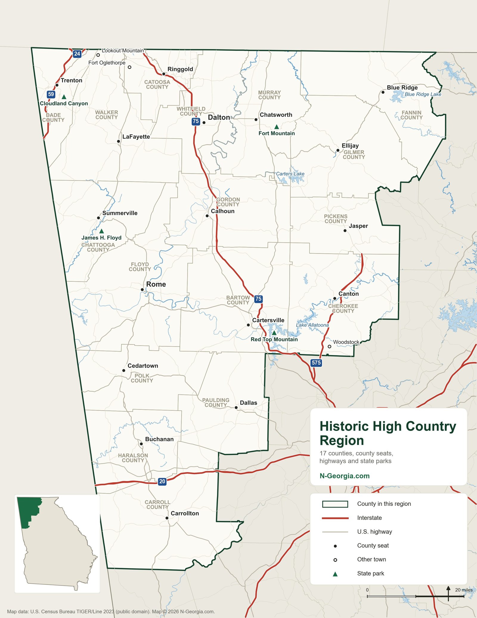
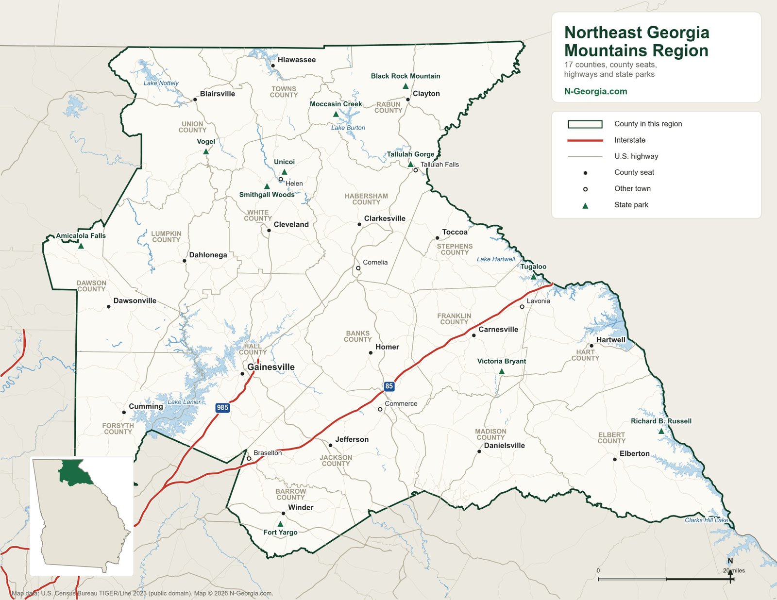
There is no single official line, so this map uses the 34 counties in Georgia’s two northernmost travel regions, as defined by the Georgia Department of Economic Development. The western half is the Historic High Country (17 counties, including Rome, Dalton, Cartersville, Ellijay and Blue Ridge). The eastern half is the Northeast Georgia Mountains (17 counties, including Gainesville, Dahlonega, Helen, Clayton and Toccoa). The shaded area outside the green line is the rest of Georgia, with metro Atlanta at the bottom center.
For a closer look at either half, see the Historic High Country map and the Northeast Georgia Mountains map.
Largest Cities and Towns in North Georgia
122 incorporated cities and towns lie at least partly in the 34 counties. These are the 20 largest, using the U.S. Census Bureau’s 2024 population estimates. For every city and town in the state, see our list of all Georgia cities.
| City or town | County | 2024 population |
|---|---|---|
| Gainesville | Hall | 47,712 |
| Woodstock | Cherokee | 39,381 |
| Rome | Floyd | 38,747 |
| Canton | Cherokee | 38,049 |
| Dalton | Whitfield | 34,970 |
| Carrollton | Carroll | 28,306 |
| Cartersville | Bartow | 25,082 |
| Winder | Barrow | 20,628 |
| Holly Springs | Cherokee | 20,133 |
| Villa Rica | Carroll / Douglas | 20,095 |
| Calhoun | Gordon | 19,592 |
| Buford | Gwinnett / Hall | 18,642 |
| Braselton | Barrow / Gwinnett / Hall / Jackson | 17,390 |
| Jefferson | Jackson | 16,459 |
| Dallas | Paulding | 15,062 |
| Flowery Branch | Hall | 12,292 |
| Fort Oglethorpe | Catoosa / Walker | 10,614 |
| Cedartown | Polk | 10,313 |
| Cumming | Forsyth | 10,175 |
| Auburn | Barrow / Gwinnett | 10,094 |
Cities listed with more than one county straddle a county line. Villa Rica, Buford, Braselton and Auburn extend into metro Atlanta counties.
North Georgia Mountains on the Map
The highest ground is in the Blue Ridge Mountains along the North Carolina line, in Union, Towns, Rabun, Lumpkin and Fannin counties. The four peaks marked with brown triangles are:
- Brasstown Bald. The highest point in Georgia at 4,784 feet, with an observation deck at the summit. It sits between Blairsville and Hiawassee. See Brasstown Wilderness.
- Rabun Bald. Georgia's second-highest peak (4,696 feet), near Sky Valley in northeast Rabun County.
- Blood Mountain. The highest point on the Appalachian Trail in Georgia, rising above Neels Gap a few miles south of Vogel State Park. See Blood Mountain Wilderness.
- Springer Mountain. The southern end of the Appalachian Trail, north of Amicalola Falls State Park. See Blood Mountain vs. Springer Mountain.
Farther west, Fort Mountain rises east of Chatsworth, and Lookout Mountain runs along the Alabama line in Dade and Walker counties, with Cloudland Canyon cut into its western edge. For trails, see the Georgia Appalachian Trail guide and our best hikes in North Georgia.
Lakes on the Map
- Lake Lanier: mostly in Hall and Forsyth counties, northeast of Atlanta
- Lake Allatoona: Bartow and Cherokee counties (plus a corner of Cobb), east of Cartersville
- Carters Lake: Murray and Gilmer counties, south of Chatsworth
- Lake Blue Ridge: Fannin County, near the town of Blue Ridge
- Lake Nottely: Union County, northwest of Blairsville
- Lake Chatuge: Towns County at Hiawassee, crossing into North Carolina
- Lake Burton: Rabun County, west of Clayton
- Lake Rabun and Seed Lake: Rabun County, downstream of Lake Burton
- Lake Tugalo and Lake Yonah: Rabun, Habersham and Stephens counties, on the South Carolina line
- Lake Hartwell: Hart, Franklin and Stephens counties, on the South Carolina line
More lakes, including smaller fishing lakes, are in our Georgia lakes guide.
State Parks in North Georgia
The green triangles mark these 17 state parks:
- Amicalola Falls State Park (Dawson County)
- Black Rock Mountain State Park (Rabun County)
- Cloudland Canyon State Park (Dade County)
- Fort Mountain State Park (Murray County)
- Don Carter State Park (Hall County)
- Fort Yargo State Park (Barrow County)
- James H. (Sloppy) Floyd State Park (Chattooga County)
- Moccasin Creek State Park (Rabun County)
- Red Top Mountain State Park (Bartow County)
- Richard B. Russell State Park (Elbert County)
- Smithgall Woods State Park (White County)
- Tallulah Gorge State Park (Rabun and Habersham counties)
- Tugaloo State Park (Franklin County)
- Unicoi State Park (White County)
- Victoria Bryant State Park (Franklin County)
- Vogel State Park (Union County)
- Watson Mill Bridge State Park (Madison County)
Every Georgia state park is on our Georgia state parks map.
Main Roads Through North Georgia
Interstates. I-75 is the main route through the northwest, passing Cartersville, Calhoun and Dalton on the way to Chattanooga. I-575 leaves I-75 at Kennesaw and runs north through Canton toward Jasper. I-985 runs from I-85 near Suwanee to Gainesville. I-85 crosses the northeast past Braselton, Commerce and Lavonia, and I-20 crosses Carroll and Haralson counties on the way to Alabama.
U.S. highways in the mountains. Once you leave the interstates, the U.S. highways do most of the work:
- US 76 runs east to west across the top of the state, through Clayton, Hiawassee, Young Harris, Blairsville, Blue Ridge, Ellijay and Chatsworth.
- US 23/441 runs north from Cornelia through Tallulah Falls, Tiger and Clayton to Dillard and the North Carolina line.
- US 129 connects Jefferson, Gainesville, Cleveland and Blairsville.
- US 19 connects Cumming, Dahlonega and Blairsville.
- US 27 runs down the west side of the state through Rossville, LaFayette, Summerville, Rome, Buchanan and Carrollton.
- US 41 parallels I-75 through Ringgold, Calhoun, Adairsville and Cartersville.
For the statewide road network, see the Georgia cities and highways map.
North Georgia Counties and County Seats
| County | County seat | Part of North Georgia |
|---|---|---|
| Banks | Homer | Northeast (Northeast Georgia Mountains) |
| Barrow | Winder | Northeast (Northeast Georgia Mountains) |
| Bartow | Cartersville | Northwest (Historic High Country) |
| Carroll | Carrollton | Northwest (Historic High Country) |
| Catoosa | Ringgold | Northwest (Historic High Country) |
| Chattooga | Summerville | Northwest (Historic High Country) |
| Cherokee | Canton | Northwest (Historic High Country) |
| Dade | Trenton | Northwest (Historic High Country) |
| Dawson | Dawsonville | Northeast (Northeast Georgia Mountains) |
| Elbert | Elberton | Northeast (Northeast Georgia Mountains) |
| Fannin | Blue Ridge | Northwest (Historic High Country) |
| Floyd | Rome | Northwest (Historic High Country) |
| Forsyth | Cumming | Northeast (Northeast Georgia Mountains) |
| Franklin | Carnesville | Northeast (Northeast Georgia Mountains) |
| Gilmer | Ellijay | Northwest (Historic High Country) |
| Gordon | Calhoun | Northwest (Historic High Country) |
| Habersham | Clarkesville | Northeast (Northeast Georgia Mountains) |
| Hall | Gainesville | Northeast (Northeast Georgia Mountains) |
| Haralson | Buchanan | Northwest (Historic High Country) |
| Hart | Hartwell | Northeast (Northeast Georgia Mountains) |
| Jackson | Jefferson | Northeast (Northeast Georgia Mountains) |
| Lumpkin | Dahlonega | Northeast (Northeast Georgia Mountains) |
| Madison | Danielsville | Northeast (Northeast Georgia Mountains) |
| Murray | Chatsworth | Northwest (Historic High Country) |
| Paulding | Dallas | Northwest (Historic High Country) |
| Pickens | Jasper | Northwest (Historic High Country) |
| Polk | Cedartown | Northwest (Historic High Country) |
| Rabun | Clayton | Northeast (Northeast Georgia Mountains) |
| Stephens | Toccoa | Northeast (Northeast Georgia Mountains) |
| Towns | Hiawassee | Northeast (Northeast Georgia Mountains) |
| Union | Blairsville | Northeast (Northeast Georgia Mountains) |
| Walker | LaFayette | Northwest (Historic High Country) |
| White | Cleveland | Northeast (Northeast Georgia Mountains) |
| Whitfield | Dalton | Northwest (Historic High Country) |
All 159 counties are on the Georgia counties map.
Printing the Map
The PDF version is sized for standard letter paper in landscape (11 by 8.5 inches). Print it at “actual size” or “fit to page” for the cleanest result. If you would rather keep it on your phone, save the PDF, which stays sharp when you zoom in.
Common Questions
What counties are in North Georgia?
On this map, North Georgia is the 34 counties in the state's two northern travel regions: Banks, Barrow, Bartow, Carroll, Catoosa, Chattooga, Cherokee, Dade, Dawson, Elbert, Fannin, Floyd, Forsyth, Franklin, Gilmer, Gordon, Habersham, Hall, Haralson, Hart, Jackson, Lumpkin, Madison, Murray, Paulding, Pickens, Polk, Rabun, Stephens, Towns, Union, Walker, White and Whitfield. The northern suburbs of Atlanta in Cobb, north Fulton and Gwinnett counties are often called north Georgia too, but they belong to the Metro Atlanta region.
What is the largest city in North Georgia?
Gainesville, in Hall County, with a 2024 Census Bureau estimate of 47,712 people. Woodstock (39,381), Rome (38,747), Canton (38,049) and Dalton (34,970) round out the five largest.
What is the highest mountain in North Georgia?
Brasstown Bald, at 4,784 feet, is the highest point in Georgia. Rabun Bald, at 4,696 feet in Rabun County, is the second highest.
Which interstates go to North Georgia?
I-75 runs north from Atlanta through Cartersville, Calhoun and Dalton to Tennessee. I-575 branches off I-75 into Cherokee and Pickens counties, I-985 runs to Gainesville, and I-85 heads northeast past Commerce and Lavonia to South Carolina. I-24 and I-59 cross Dade County in the far northwest corner.
Is there a printable North Georgia map?
Yes. The map on this page is available as a free letter-size PDF (11 by 8.5 inches, landscape) that you can print or save to your phone for areas with weak cell service.