
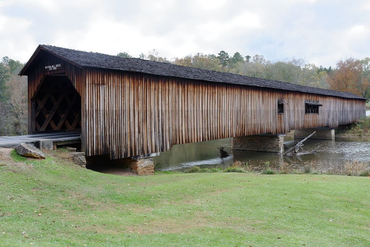
Photo: Jud McCranie, CC BY-SA 3.0, via Wikimedia Commons
Georgia still has 14 historic covered bridges built between the 1840s and 1915, plus a mill-and-bridge at George L. Smith State Park and a few newer covered bridges built in the old style. Below are all 18 you can go see, grouped by region, with the year built, length and the thing most people want to know first: can you drive through it, walk across it or only look at it from the road. We checked each bridge in October 2026 against state park, county and tourism sources. Six still carry cars. Most of the rest sit in small parks with free parking and a picnic table.
- Drive-through bridgesWatson Mill, Elder's Mill, Concord, Red Oak Creek, Haralson Mill, Stone Mountain
- LongestWatson Mill Bridge, 229 feet, in Watson Mill Bridge State Park near Comer
- OldestRed Oak Creek near Woodbury, built in the 1840s and credited to Horace King
- CostMost are free; Watson Mill, Smithgall Woods and George L. Smith require a $10 state ParkPass
- North Georgia
- Athens Area
- Metro Atlanta
- West and Middle Georgia
- South Georgia
- Map
- Lost Bridges
- Common Questions
North Georgia Covered Bridges
1. Stovall Mill Bridge, Sautee Nacoochee
Built: 1895 · Length: under 40 feet · Access: walk only, free
One of the smallest covered bridges in Georgia spans Chickamauga Creek in White County, just off GA 255 a few miles from Helen. Will Pardue built it after an earlier bridge washed away, and it appeared in the 1951 film I'd Climb the Highest Mountain. There is a small parking area, a picnic spot and a historical marker. The inside walls are covered in graffiti, but the creek setting makes it an easy stop on a Helen or Sautee Nacoochee day.
2. Bay's Bridge, Smithgall Woods State Park, Helen
Built: mid-1990s · Access: on foot or bike inside the park, $10 ParkPass
A modern covered bridge over Dukes Creek, dedicated to the memory of Elizabeth "Bay" Smithgall Watts. It sits along the park's main road and trail corridor, about 1.4 miles from the entrance, near the group camp. All visitors register at the visitor center first. The park is open 7 a.m. to dark. It is not historic, but it is one of the prettiest covered bridges in the mountains. See also our Smithgall Woods State Park page.
3. Lula Bridge (Hyder or Blind Susie Bridge), Lula
Built: 1915 · Length: 34 feet · Access: private property, view from Antioch Road only
Georgia's smallest historic covered bridge crosses Grove Creek just south of Lula in Banks County. It carried traffic until 1969 and was rebuilt on its original foundations in the 1970s. The bridge is on private land and posted, so look from the road and do not walk onto the property.
4. Cromer's Mill Bridge, Carnesville
Built: 1906-07 · Length: about 132 feet · Access: closed to cars, roadside stop
J. M. "Pink" Hunt built this Town lattice bridge over Nails Creek in Franklin County, pinning the crisscrossed planks with wooden pegs. It no longer carries traffic and has a historical marker. Find it about 8 miles south of Carnesville off GA 106 on Cromer's Mill Road. Listed on the National Register of Historic Places since 1976.
5. Hurricane Shoals Bridge, Maysville
Rebuilt: 2002 · Length: 127 feet · Access: inside a free county park
The original 1880s bridge over the North Oconee River was burned by vandals in 1972. Jackson County rebuilt it in the Town lattice style, and it was dedicated in 2002. Today it is the centerpiece of Hurricane Shoals Park, a county park with granite shoals, a heritage village and trails. The park is open 7 a.m. to 9 p.m. with free admission. Dogs, fishing and alcohol are not allowed.
6. Poole's Mill Bridge, Cumming
Built: 1901 · Length: about 95 feet · Access: footbridge in a free county park
Bud Gentry finished this Town lattice bridge over Settendown Creek after the first contractor drilled the holes in the wrong places, and you can still see the misplaced holes in the timbers. Forsyth County turned the site into Poole's Mill Park in 1997. The bridge sits right above the shoals, with a playground, picnic tables and short trails nearby.
Sponsor This Guide
Run a cabin rental, restaurant or attraction near one of these bridges? Put your business in front of people planning a covered bridge drive. See our advertising options or download the 2026 media kit (PDF).
Athens Area Covered Bridges
7. Watson Mill Bridge, Comer
Built: 1885 · Length: 229 feet · Access: drive through, $10 ParkPass
The longest covered bridge in Georgia spans the South Fork of the Broad River above a wide stretch of rock shoals. Washington W. King, son of Horace King, built it. It still carries cars into Watson Mill Bridge State Park, with a 9-foot height clearance and a 3-ton weight limit, so RV and horse-trailer campers use the park's other entrances. The park is open 7 a.m. to 10 p.m. Call 706-783-5349.
8. Elder's Mill Bridge, Watkinsville
Built: 1897 · Length: 100 feet · Access: drive through, one lane, free
Nathaniel Richardson built this Town lattice bridge over Calls Creek, and it was moved by wagon to its spot over Rose Creek in 1924. It is one of the few Georgia covered bridges that still carries traffic without steel beams underneath. It is on Elder Mill Road, south of Watkinsville off GA 15. There is a small pull-off at the north end of the bridge.
9. Howard's Bridge, near Smithonia
Built: 1904-05 · Length: about 165 feet · Access: closed to traffic, view from the old road
Once called the Big Clouds Creek Bridge, it had the longest single span of any surviving Georgia covered bridge until a middle pier was added. It sits in a very rural part of Oglethorpe County about 3 miles southeast of Smithonia, at the end of the old Smithonia Road alignment, which is now a private driveway. View it from the public road and respect the posted property. Pair it with Watson Mill, a short drive away.
Metro Atlanta Covered Bridges
10. Concord Bridge, Smyrna
Built: 1872 · Length: 131.7 feet · Access: drive through, one lane
The busiest covered bridge in Georgia crosses Nickajack Creek on Concord Road in Cobb County, next to the Ruff's Mill Civil War site and the Silver Comet Trail. Over-height trucks and vans hit its protective beams often, which closes the bridge for repairs on short notice, so check Cobb County's updates before you go. Traffic is steady, so do not stop on the bridge or in the road for photos.
11. Washington W. King Bridge, Stone Mountain Park
Built: 1891 · Length: 151 feet · Access: drive or walk across, park parking fee
Washington W. King built this bridge over the North Oconee River in Athens. Clarke County gave it to Stone Mountain Park in the 1960s, and it now carries cars and walkers across to Indian Island, where a small lot sits at the start of the King's Trail, a flat loop of about a mile named for its builder. The bridge is near the Grist Mill. A daily Stone Mountain Park parking pass is required to drive in.
12. Haralson Mill Bridge, Conyers
Built: 1997 · Length: 150 feet · Access: drive through, free
Rockdale County built this modern covered bridge over Mill Rock Creek at 4400 Haralson Mill Road in the old style. Underneath the wooden lattice and stone facing is a concrete road bridge, and it has cameras, smoke detectors and sprinklers. It sits just north of the Haralson Mill Historic District, with a parking area nearby.
13. Euharlee Bridge, Euharlee
Built: 1886 · Length: 137.6 feet · Access: walk only, free
Washington W. King built this Town lattice bridge over Euharlee Creek next to the ruins of Daniel Lowry's mill, west of Cartersville in Bartow County. It is closed to vehicles but open for walking every day. The free Euharlee Welcome Center and History Museum across the road tells the story of the bridge and the town. Call 770-607-2017 for museum hours.
West and Middle Georgia Covered Bridges
14. Red Oak Creek Bridge, Woodbury
Built: 1840s · Length: nearly 400 feet with its approaches · Access: drive through, one lane
Georgia's oldest covered bridge is credited to Horace King, the formerly enslaved builder who became one of the South's best-known bridge engineers. Counting its long wooden approaches, it is the longest wooden bridge in the state. It is on Covered Bridge Road north of Woodbury in Meriwether County, about 12 miles north of Warm Springs. Clearance is low, so skip it in a tall van, RV or anything with a roof rack.
15. King Wehadkee Bridge, LaGrange
Built: 1890 · Access: walk through, free
George King, Horace King's son, built this bridge over Wehadkee Creek. It spent nearly 60 years at Callaway Gardens after West Point Lake was planned, then came home to LaGrange in 2022. It now stands beside Horace King's grave at Mulberry Street Cemetery, 101 W. Mulberry Street, and links the cemetery to The Thread, the city's multi-use trail. If you have older notes that send you to Callaway Gardens for this bridge, they are out of date.
16. Auchumpkee Creek Bridge, Thomaston
Built: 1892, rebuilt 1997 · Length: 96 feet · Access: walk only, free
A 1994 flood knocked this Town lattice bridge off its piers, and Upson County rebuilt it in 1997 with the original timbers and traditional methods. It is on Allen Road off U.S. 19, roughly 10 to 12 miles south of Thomaston, with a shaded picnic area and parking. It is also called Hootenville or Zorn's Mill Bridge. The Thomaston-Upson Chamber welcome center has maps.
South Georgia Covered Bridges
17. Coheelee Creek Bridge, Blakely
Built: 1891 · Access: walk only, free county park
The southernmost historic covered bridge in the United States sits on Old River Road about 9 miles southwest of Blakely in Early County. Its truss uses angled metal rods, a design that sets it apart from the other Georgia bridges. Fannie Askew Williams Park next to it has picnic tables, and a historical marker tells the story. Combine it with Kolomoki Mounds nearby.
18. Parrish Mill, George L. Smith State Park, Twin City
Built: 1880 · Access: inside the park, $10 ParkPass
Not a typical road bridge: Parrish Mill combines a mill house, covered bridge and dam in one structure on the park's blackwater millpond, which is full of cypress and tupelo trees. Paddling the pond gives the best view. The park is in Emanuel County and is open 7 a.m. to 10 p.m. Call 478-763-2759.
Covered Bridges in Georgia Map
Our Georgia covered bridges map plots the historic bridges on a clickable state map with a numbered directory. There is also a printable covered bridges map (PDF) for the glove box. Good loops: Watson Mill, Howard's and Elder's Mill in one Athens-area day; Stovall Mill, Bay's Bridge and Hurricane Shoals with a Helen trip; Concord, Haralson Mill and the Stone Mountain bridge around Atlanta; and Red Oak Creek, the King Wehadkee Bridge and Auchumpkee Creek on a west Georgia drive.
Tips for Visiting
- Drive-through bridges are narrow and mostly one lane. Pull through slowly, yield to oncoming cars and obey the posted height and weight limits.
- Do not park on the bridge or in the road to take photos. Use the pull-offs and lots listed above.
- Fall color peaks in late October and early November in North Georgia, and that is when the bridge parks are busiest.
- Several bridges sit next to private land. Stay on public ground, especially at Lula and Howard's.
Georgia Covered Bridges That Are Gone
Some bridges you may see on older lists no longer stand. The Kesler Bridge in Banks County collapsed around 1980, the New Salem Bridge in Jackson County collapsed in 1984, the White Oak Creek Bridge in Meriwether County burned in 1985, and the Kilgore Mill Bridge on the Barrow-Walton county line was destroyed by arson in 1993.
Common Questions
How many covered bridges are in Georgia?
Fourteen historic covered bridges built between the 1840s and 1915 still stand in Georgia, from Red Oak Creek near Woodbury to Coheelee Creek near Blakely. Counting the 1880 Parrish Mill at George L. Smith State Park and newer bridges such as Haralson Mill in Conyers, the rebuilt Hurricane Shoals Bridge and Bay's Bridge at Smithgall Woods, there are 18 covered bridges you can visit.
Which covered bridges in Georgia can you drive through?
Six still carry cars: Watson Mill Bridge near Comer, Elder's Mill Bridge near Watkinsville, Concord Bridge in Smyrna, Red Oak Creek Bridge near Woodbury, Haralson Mill Bridge in Conyers and the Washington W. King Bridge in Stone Mountain Park. Drive slowly and yield on the narrow ones; Watson Mill has a 9-foot height clearance and 3-ton weight limit. Concord Bridge closes often after over-height vehicles hit its protective beams.
What is the longest covered bridge in Georgia?
Watson Mill Bridge, built in 1885 over the South Fork of the Broad River, is the longest covered bridge in Georgia at 229 feet. Red Oak Creek Bridge near Woodbury is the longest wooden bridge in the state if you count its long approaches, at nearly 400 feet.
What is the oldest covered bridge in Georgia?
Red Oak Creek Bridge in Meriwether County, built in the 1840s and credited to Horace King, is the oldest covered bridge in Georgia. It still carries one lane of traffic on Covered Bridge Road north of Woodbury.
Is there a map of covered bridges in Georgia?
Yes. N-Georgia.com has a clickable Georgia covered bridges map at n-georgia.com/bridgesmap.htm with a numbered directory of each bridge, plus a printable PDF map. Good day trips are Watson Mill, Howard's and Elder's Mill near Athens, or Stovall Mill, Bay's Bridge and Hurricane Shoals near Helen.
Who was Horace King?
Horace King was a formerly enslaved builder who became one of the best-known bridge engineers in the 19th-century South. Red Oak Creek Bridge is credited to him, his son Washington W. King built the Watson Mill, Euharlee and Stone Mountain bridges, and his son George King built the King Wehadkee Bridge, now in LaGrange beside Horace King's grave.
What happened to the Callaway Gardens covered bridge?
The bridge, now called the King Wehadkee Covered Bridge, left Callaway Gardens and returned to LaGrange in 2022. It stands at Mulberry Street Cemetery, 101 W. Mulberry Street, next to Horace King's grave, and connects to The Thread trail, so the public can walk through it again.
Sources we checked
Every bridge in this guide was checked in October 2026 against the state park, county or tourism office responsible for it, plus Georgia Historical Society markers and National Register records. Bridges that carry traffic can close after a crash, so confirm before a long drive:
- Georgia State Parks: Watson Mill Bridge: bridge length, clearance and weight limit, hours
- Georgia State Parks: Smithgall Woods: hours and visitor registration
- Georgia State Parks: George L. Smith: Parrish Mill, hours and phone
- Explore Georgia: Guide to Georgia's Covered Bridges: status and history of each bridge
- Explore Georgia: King Wehadkee Covered Bridge and Mulberry Street Cemetery: the bridge's 2022 move to LaGrange
- Cobb County Courier: Concord Bridge closures after beam strikes
- Visit Cartersville: Euharlee bridge and museum
- Explore Georgia: Hurricane Shoals Park: hours and park rules
- City of Blakely: Coheelee Creek Bridge location
- Georgia Historical Society markers: Cromer's Mill, Poole's Mill, Howard's and Red Oak Creek
- GPB News: Washington W. King Bridge and the King's Trail at Stone Mountain
Spot something out of date? Tell us. Read more about how we research our guides.