List of all 537 cities and towns in Georgia
Every Georgia city and town with its county, travel region and 2024 population, searchable and sortable.
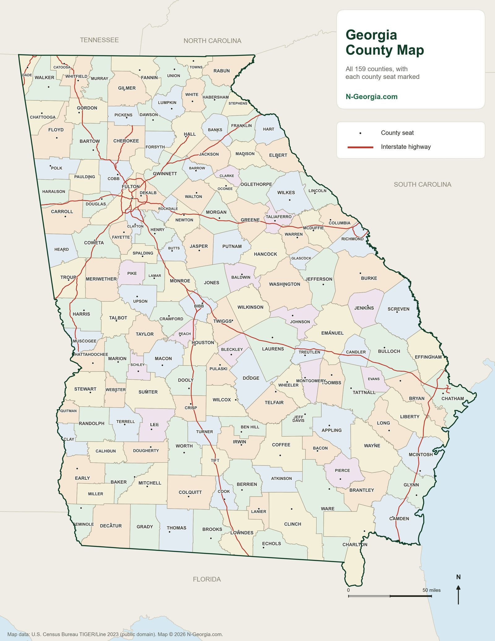
All 159 Georgia counties
Every county with its county seat, in one list.
Georgia’s 159 counties make it second only to Texas for county count in the whole country, and that patchwork is a big part of what makes this state so interesting to explore.
Teachers: a blank Georgia county outline map and region and physical features maps are free to print on our Georgia Studies maps page.
Each little town below belongs to a county with its own courthouse, its own local flavor, and usually a park or two worth a stop. We built this list so you can find the county you are driving through and see the cities and communities inside it, then click through to that county’s own parks page for camping, fishing and picnic spots nearby.
See also our list of all 537 Georgia cities and towns, with populations and our list of all 159 counties with county seats.
Cities & Communities in Georgia Counties
| County | Cities & communities | Map |
|---|---|---|
| Appling | Baxley, Graham and Surrency | Appling County map |
| Atkinson | Pearson and Willacoochee | Atkinson County map |
| Bacon | Alma | Bacon County map |
| Baker | Newton | Baker County map |
| Baldwin | Midway-Hardwick and Milledgeville | Baldwin County map |
| Banks | Alto, Baldwin, Gillsville, Homer, Lula and Maysville | Banks County map |
| Barrow | Auburn, Bethlehem, Braselton, Carl, Russell, Statham and Winder | Barrow County map |
| Bartow | Adairsville, Cartersville, Cassville, Emerson, Euharlee, Funkhouser, Kingston, Pine Log, Rydal, Taylorsville and White | Bartow County map |
| Ben Hill | Fitzgerald | Ben Hill County map |
| Berrien | Alapaha, Enigma, Nashville and Ray City | Berrien County map |
| Bibb | Lizella, Macon and Payne | Bibb County map |
| Bleckley | Allentown and Cochran | Bleckley County map |
| Brantley | Hoboken, Hortense, Nahunta and Waynesville | Brantley County map |
| Brooks | Barney, Barwick, Morven, Pavo and Quitman | Brooks County map |
| Bryan | Ellabell, Fort Stewart, Groveland, Pembroke and Richmond Hill | Bryan County map |
| Bulloch | Brooklet, Jimps, Portal, Register and Statesboro | Bulloch County map |
| Burke | Blythe, Girard, Gough, Keysville, Midville, Rosier, Sardis, Vidette and Waynesboro | Burke County map |
| Butts | Flovilla, Jackson and Jenkinsburg | Butts County map |
| Calhoun | Arlington, Edison, Leary and Morgan | Calhoun County map |
| Camden | Cumberland Island, Kings Bay Base, Kingsland, St. Marys, White Oak and Woodbine | Camden County map |
| Candler | Aline, Metter and Pulaski | Candler County map |
| Carroll | Banning, Bowdon, Bremen, Carrollton, Clem, Lowell, Mount Zion, Roopville, Temple, Villa Rica and Whitesburg | Carroll County map |
| Catoosa | Fort Oglethorpe, Graysville, Indian Springs, Lakeview and Ringgold | Catoosa County map |
| Charlton | Folkston, Homeland and Saint George | Charlton County map |
| Chatham | Bloomingdale, Garden City, Georgetown, Isle Of Hope-Dutch Island, Montgomery, Ossabaw Island, Pooler, Port Wentworth, Savannah, Skidaway Island, Thunderbolt, Tybee Island, Vernonburg, Whitemarsh Island and Wilmington Island | Chatham County map |
| Chattahoochee | Cusseta | Chattahoochee County map |
| Chattooga | Berryton, Cloudland, Lyerly, Menlo, Summerville and Trion | Chattooga County map |
| Cherokee | Ball Ground, Canton, Gober, Holly Springs, Lathemtown, Mountain Park, Nelson, Waleska and Woodstock | Cherokee County map |
| Clarke | Athens, Bogart, Gaines School, Whitehall and Winterville | Clarke County map |
| Clay | Bluffton and Fort Gaines | Clay County map |
| Clayton | Bonanza, College Park, Conley, Ellenwood, Forest Park, Irondale, Jonesboro, Lake City, Lovejoy, Morrow, Mountain View, Rex and Riverdale | Clayton County map |
| Clinch | Argyle, Cogdell, Du Pont, Fargo and Homerville | Clinch County map |
| Cobb | Acworth, Austell, Clarkdale, Fair Oaks, Kennesaw, Leland, Mableton, Marietta, Powder Springs, Smyrna and Vinings | Cobb County map |
| Coffee | Ambrose, Broxton, Douglas, Nicholls and West Green | Coffee County map |
| Colquitt | Berlin, Doerun, Ellenton, Funston, Moultrie, Norman Park, Omega and Riverside | Colquitt County map |
| Columbia | Appling, Evans, Fort Eisenhower, Grovetown, Harlem and Martinez | Columbia County map |
| Cook | Adel, Cecil, Lenox and Sparks | Cook County map |
| Coweta | Corinth, East Newnan, Grantville, Haralson, Madras, Moreland, Newnan, Palmetto, Raymond, Sargent, Senoia, Sharpsburg and Turin | Coweta County map |
| Crawford | Knoxville, Lee Pope, Musella, Roberta and Zenith | Crawford County map |
| Crisp | Arabi and Cordele | Crisp County map |
| Dade | Rising Fawn and Trenton | Dade County map |
| Dawson | Dawsonville | Dawson County map |
| Decatur | Attapulgus, Bainbridge, Brinson, Climax and Fowlstown | Decatur County map |
| DeKalb | Atlanta, Avondale Estates, Belvedere Park, Brookhaven, Candler-McAfee, Chamblee, Clarkston, Decatur, Doraville, Druid Hills, Dunwoody, Gresham Park, Lithonia, North Decatur, North Druid Hills, Panthersville, Pine Lake, Redan, Scottdale, Stone Mountain, Stonecrest and Tucker | DeKalb County map |
| Dodge | Chauncey, Chester, Eastman, Milan and Rhine | Dodge County map |
| Dooly | Byromville, Dooling, Lilly, Pinehurst, Unadilla and Vienna | Dooly County map |
| Dougherty | Albany and Putney | Dougherty County map |
| Douglas | Austell, Douglasville, Lithia Springs, Villa Rica and Winston | Douglas County map |
| Early | Arlington, Blakely, Cedar Springs, Damascus and Jakin | Early County map |
| Echols | Statenville | Echols County map |
| Effingham | Clyo, Eden, Guyton, Meldrim, Rincon and Springfield | Effingham County map |
| Elbert | Bowman and Elberton | Elbert County map |
| Emanuel | Adrian, Garfield, Nunez, Oak Park, Stillmore, Summertown, Swainsboro and Twin City | Emanuel County map |
| Evans | Bellville, Claxton, Daisy, Fort Stewart and Hagan | Evans County map |
| Fannin | Blue Ridge, Dial, Hemp, McCaysville, Mineral Bluff and Morganton | Fannin County map |
| Fayette | Brooks, Fayetteville, Peachtree City, Starrs Mill, Tyrone and Woolsey | Fayette County map |
| Floyd | Armuchee, Cave Spring, Coosa, Crystal Springs, Lindale, Mount Berry, Rome, Shannon and Silver Creek | Floyd County map |
| Forsyth | Cumming and Ducktown | Forsyth County map |
| Franklin | Canon, Carnesville, Franklin Springs, Gumlog, Lavonia, Martin and Royston | Franklin County map |
| Fulton | Alpharetta, Atlanta, Bolton, Chattahoochee Hills, College Park, Crabapple, East Point, Fairburn, Hapeville, Johns Creek, Milton, Mountain Park, Palmetto, Red Oak, Roswell, Sandy Springs, South Fulton, Stonewall and Union City | Fulton County map |
| Gilmer | Cherry Log, East Ellijay, Ellijay and Whitestone | Gilmer County map |
| Glascock | Edge Hill, Gibson and Mitchell | Glascock County map |
| Glynn | Brunswick, Country Club Estates, Dock Junction, Jekyll Island, Sea Island and St. Simons Island | Glynn County map |
| Gordon | Calhoun, Fairmount, Oakman, Plainville, Ranger, Resaca and Sugar Valley | Gordon County map |
| Grady | Cairo, Calvary, Reno and Whigham | Grady County map |
| Greene | Greensboro, Penfield, Siloam, Union Point, White Plains and Woodville | Greene County map |
| Gwinnett | Auburn, Berkeley Lake, Braselton, Buford, Dacula, Duluth, Gloster, Grayson, Lawrenceville, Lilburn, Loganville, Mountain Park, Norcross, Peachtree Corners, Rest Haven, Snellville, Sugar Hill and Suwanee | Gwinnett County map |
| Habersham | Alto, Baldwin, Batesville, Clarkesville, Cornelia, Demorest, Habersham, Hollywood, Mount Airy, Raoul, Tallulah Falls and Turnerville | Habersham County map |
| Hall | Braselton, Buford, Chestnut Mountain, Chicopee, Clermont, Flowery Branch, Gainesville, Gainesville Mills, Gillsville, Lake Lanier Islands, Lula, Murrayville, New Holland, Oakwood, Rest Haven and Westside | Hall County map |
| Hancock | Devereux, Mayfield and Sparta | Hancock County map |
| Haralson | Bremen, Buchanan, Felton, Tallapoosa, Temple and Waco | Haralson County map |
| Harris | Cataula, Ellerslie, Hamilton, Pine Mountain, Shiloh, Waverly Hall, West Point and Whitesville | Harris County map |
| Hart | Bowersville, Canon, Hartwell, Lavonia, Reed Creek and Royston | Hart County map |
| Heard | Centralhatchee, Corinth, Ephesus, Franklin and Roosterville | Heard County map |
| Henry | Blacksville, Hampton, Locust Grove, McDonough and Stockbridge | Henry County map |
| Houston | Bonaire, Byron, Centerville, Clinchfield, Kathleen, Pabst, Perry, Robins Air Force Base and Warner Robins | Houston County map |
| Irwin | Fitzgerald, Irwinville, Mystic and Ocilla | Irwin County map |
| Jackson | Arcade, Braselton, Center, Commerce, Hoschton, Jefferson, Maysville, Nicholson, Pendergrass and Talmo | Jackson County map |
| Jasper | Farrar, Kelly, Monticello and Shady Dale | Jasper County map |
| Jeff Davis | Denton and Hazlehurst | Jeff Davis County map |
| Jefferson | Avera, Bartow, Fort Eisenhower, Keysville, Louisville, Moxley, Stapleton, Wadley and Wrens | Jefferson County map |
| Jenkins | Herndon and Millen | Jenkins County map |
| Johnson | Adrian, Kite and Wrightsville | Johnson County map |
| Jones | Clinton, Gray, Haddock, Macon and Round Oak | Jones County map |
| Lamar | Aldora, Barnesville and Milner | Lamar County map |
| Lanier | Lakeland and Stockton | Lanier County map |
| Laurens | Allentown, Cadwell, Dexter, Dublin, Dudley, East Dublin, Montrose and Rentz | Laurens County map |
| Lee | Leesburg and Smithville | Lee County map |
| Liberty | Allenhurst, Dorchester, Flemington, Fort Stewart, Gumbranch, Hinesville, McIntosh, Midway, Riceboro and Walthourville | Liberty County map |
| Lincoln | Lincolnton | Lincoln County map |
| Long | Fort Stewart and Ludowici | Long County map |
| Lowndes | Clyattville, Dasher, Hahira, Lake Park, Moody AFB, Naylor, Remerton and Valdosta | Lowndes County map |
| Lumpkin | Dahlonega | Lumpkin County map |
| Macon | Ideal, Marshallville, Montezuma and Oglethorpe | Macon County map |
| Madison | Carlton, Colbert, Comer, Danielsville, Hull, Ila and Royston | Madison County map |
| Marion | Buena Vista and Juniper | Marion County map |
| McDuffie | Boneville, Dearing, Fort Eisenhower and Thomson | McDuffie County map |
| McIntosh | Crescent, Darien, Eulonia, Meridian, Pine Harbor, Ridgeville, Sapelo Island, Shellman Bluff, Townsend and Valona | McIntosh County map |
| Meriwether | Alvaton, Gay, Greenville, Haralson, Lone Oak, Luthersville, Manchester, Pine Mountain, Warm Springs and Woodbury | Meriwether County map |
| Miller | Colquitt | Miller County map |
| Mitchell | Baconton, Camilla, Cotton, Hinsonton, Hopeful, Meigs, Pelham and Sale City | Mitchell County map |
| Monroe | Bolingbroke, Culloden, Forsyth, Juliette, Percale and Smarr | Monroe County map |
| Montgomery | Ailey, Alston, Higgston, Mount Vernon, Tarrytown, Uvalda and Vidalia | Montgomery County map |
| Morgan | Bostwick, Buckhead, Madison and Rutledge | Morgan County map |
| Murray | Chatsworth, Crandall, Eton, Spring Place and Tennga | Murray County map |
| Muscogee | Bibb City, Columbus, Fortson, Midland and Upatoi | Muscogee County map |
| Newton | Covington, Dixie, Mansfield, Newborn, Oxford, Porterdale, Social Circle and Whitehall | Newton County map |
| Oconee | Bishop, Bogart, Farmington, Frogtown, North High Shoals and Watkinsville | Oconee County map |
| Oglethorpe | Arnoldsville, Crawford, Lexington and Maxeys | Oglethorpe County map |
| Paulding | Braswell, Dallas and Hiram | Paulding County map |
| Peach | Byron, Fort Valley, Perry and Warner Robins | Peach County map |
| Pickens | Blaine, Hinton, Jasper, Nelson, Talking Rock, Tate and Whitestone | Pickens County map |
| Pierce | Blackshear, Offerman, Patterson and Waycross | Pierce County map |
| Pike | Concord, Meansville, Molena, Williamson and Zebulon | Pike County map |
| Polk | Aragon, Braswell, Cedartown, Rockmart and Taylorsville | Polk County map |
| Pulaski | Hartford and Hawkinsville | Pulaski County map |
| Putnam | Eatonton | Putnam County map |
| Quitman | Georgetown and Morris | Quitman County map |
| Rabun | Clayton, Dillard, Lakemont, Mountain City, Rabun Gap, Sky Valley, Tallulah Falls, Tiger and Wiley | Rabun County map |
| Randolph | Coleman, Cuthbert and Shellman | Randolph County map |
| Richmond | Augusta, Blythe, East Boundary, Fort Eisenhower, Gracewood, Hephzibah, Martinez, McBean, South Augusta and West Augusta | Richmond County map |
| Rockdale | Conyers and Lakeview Estates | Rockdale County map |
| Schley | Ellaville | Schley County map |
| Screven | Dover, Hilltonia, Hiltonia, Newington, Oliver, Rocky Ford and Sylvania | Screven County map |
| Seminole | Donalsonville and Iron City | Seminole County map |
| Spalding | East Griffin, Experiment, Griffin, Orchard Hill and Sunny Side | Spalding County map |
| Stephens | Avalon, Eastanollee, Martin, Toccoa and Toccoa Falls | Stephens County map |
| Stewart | Lumpkin, Omaha and Richland | Stewart County map |
| Sumter | Americus, Andersonville, Cobb, De Soto, DeSoto, Leslie, Plains and Smithville | Sumter County map |
| Talbot | Geneva, Junction City, Juniper, Manchester, Talbotton and Woodland | Talbot County map |
| Taliaferro | Crawfordville and Sharon | Taliaferro County map |
| Tattnall | Cobbtown, Collins, Fort Stewart, Glennville, Manassas and Reidsville | Tattnall County map |
| Taylor | Butler and Reynolds | Taylor County map |
| Telfair | Jacksonville, Lumber City, McRae-Helena, Milan and Scotland | Telfair County map |
| Terrell | Bronwood, Dawson, Parrott and Sasser | Terrell County map |
| Thomas | Barwick, Boston, Coolidge, Meigs, Ochlocknee, Pavo and Thomasville | Thomas County map |
| Tift | Chula, Omega, Phillipsburg, Tifton, Ty Ty and Unionville | Tift County map |
| Toombs | Lyons, Santa Claus and Vidalia | Toombs County map |
| Towns | Hiawassee and Young Harris | Towns County map |
| Treutlen | Soperton | Treutlen County map |
| Troup | Hogansville, LaGrange, Mountville and West Point | Troup County map |
| Turner | Ashburn, Rebecca and Sycamore | Turner County map |
| Twiggs | Allentown, Danville, Huber and Jeffersonville | Twiggs County map |
| Union | Blairsville and Suches | Union County map |
| Upson | The Rock, Thomaston and Yatesville | Upson County map |
| Walker | Chattanooga Valley, Chickamauga, Fairview, Flintstone, Fort Oglethorpe, Kensington, LaFayette, Lakeview, Linwood, Lookout Mountain, Noble, Rock Spring, Rossville and Villanow | Walker County map |
| Walton | Between, Campton, Good Hope, Jersey, Loganville, Monroe, Social Circle and Walnut Grove | Walton County map |
| Ware | Deenwood, Manor, Millwood, Sunnyside and Waycross | Ware County map |
| Warren | Camak, Cedar Rock, Jewell, Norwood and Warrenton | Warren County map |
| Washington | Davisboro, Deepstep, Gardner, Harrison, Oconee, Riddleville, Sandersville, Tennille and Warthen | Washington County map |
| Wayne | Jesup, Odum and Screven | Wayne County map |
| Webster | Preston and Weston | Webster County map |
| Wheeler | Alamo, Glenwood, McRae-Helena and Scotland | Wheeler County map |
| White | Cleveland, Helen, Robertstown and Sautee | White County map |
| Whitfield | Cohutta, Dalton, Rocky Face, Tunnel Hill and Varnell | Whitfield County map |
| Wilcox | Abbeville, Pineview, Pitts and Rochelle | Wilcox County map |
| Wilkes | Rayle, Tignall and Washington | Wilkes County map |
| Wilkinson | Allentown, Danville, Gordon, Irwinton, Ivey, McIntyre and Toomsboro | Wilkinson County map |
| Worth | Bridgeboro, Poulan, Sumner, Sylvester and Warwick | Worth County map |
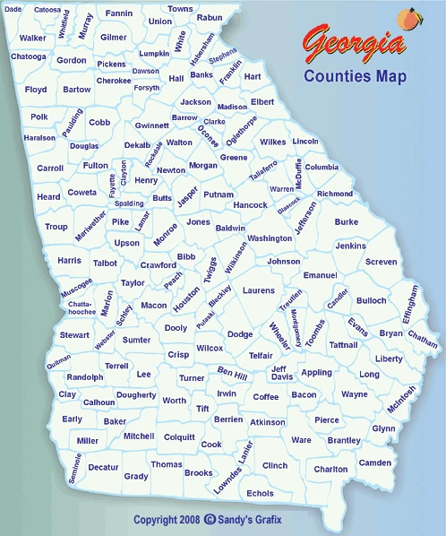
Our Original County Map