
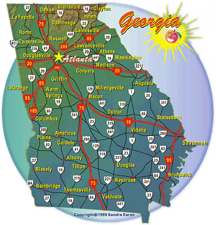
Looking for where the fun places to go are? Check out this Georgia map for highways and city locations. A printable map is included. Enjoy your trip!
We keep this map handy for planning our own road trips around Georgia, and it comes in useful whether you are mapping a weekend in the mountains or figuring out the fastest way across the state. It shows the interstates, U.S. highways and major state routes alongside the cities they connect, so you can get a quick feel for how far apart two towns really are before you commit to a route. Save the printable version to your phone or print a copy for the glove box. It is a handy backup for the stretches of rural Georgia where cell service gets spotty.
Georgia Interstate Highways: Length & Route
| Route | Miles in GA | Where it goes |
|---|---|---|
| I-16 | 166.8 | Macon to Savannah, passing Dublin and Metter |
| I-20 | 201.2 | Alabama line near Tallapoosa to the South Carolina line near Augusta, through downtown Atlanta |
| I-24 | 4.1 | A short stretch across the extreme northwest corner (Dade County), connecting toward Chattanooga, TN |
| I-59 | 20.7 | Alabama line near Rising Fawn to I-24 near Wildwood, entirely within Dade County |
| I-75 | 355.1 | Florida line near Lake Park to the Tennessee line near Ringgold, through Valdosta, Macon, Atlanta and Dalton |
| I-85 | 179.9 | Alabama line at West Point to the South Carolina line near Lavonia, through LaGrange and Atlanta |
| I-95 | 112.0 | Florida line near Kingsland to the South Carolina line near Savannah, along the coast past Brunswick |
| I-185 | 49.3 | Columbus north to I-85 near LaGrange |
| I-285 | 64.0 | The Perimeter: a full loop around metro Atlanta, connecting I-20, I-75 and I-85 |
| I-475 | 15.8 | Macon bypass, connecting to I-75 on both the north and south sides of the city |
| I-516 | 6.5 | W.F. Lynes Parkway, from Garden City to Montgomery Street in Savannah, crossing I-16 |
| I-520 | 23.3* | Bobby Jones Expressway, a three-quarter beltway around Augusta and North Augusta, SC, starting at I-20 |
| I-575 | 31.0 | I-75 in Kennesaw north into Cherokee and Pickens counties, toward the north Georgia mountains |
| I-675 | 11.0 | A shortcut from I-285 south to I-75 at Stockbridge, through Clayton and Henry counties |
| I-985 | 24.0 | I-85 near Suwanee north to Gainesville and Lake Lanier |
* I-520’s length includes its South Carolina section.