
| Metro Atlanta saw some of the most significant fighting of the Civil War's Atlanta Campaign, including the Battle of Kennesaw Mountain and the sieges that led to Sherman's capture of the city in 1864. This map marks the region's key battlefields and historic sites - click a number for that site's info, or use the numbered directory below to match each number to its name and address. These are the same numbers shown clustered near Atlanta on our statewide Civil War Sites Map. See our full Georgia Civil War Sites page for details on each location. | ||
Atlanta Georgia Civil War Historic Sites Map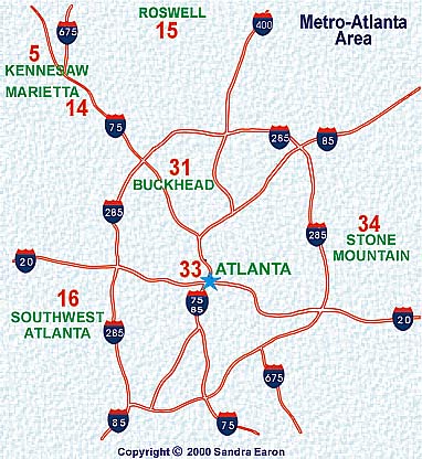
|
||
This map corresponds with the page on Civil War Sites. Click here to view that page. |
||
| Metro Atlanta Civil War Sites Directory: Matches the Numbers on the Map Above | ||
| #5 Kennesaw National Battlefield Park Address: 900 Kennesaw Mountain Dr., Kennesaw, GA 30152 Phone: 770-427-4686 | ||
| #14 Kennesaw House Address: 1 Depot St., Marietta, GA Phone: 770-794-5710 | ||
| #15 Bulloch Hall Address: 180 Bulloch Ave., Roswell, GA Phone: 770-992-1731 | ||
| #16 New Manchester Mill Ruins (Sweetwater Creek State Park) Address: 1750 Mount Vernon Road, Lithia Springs, GA 30122 Phone: 770-732-5871 | ||
| #31 Atlanta History Center Address: 130 West Paces Ferry Rd. NW, Atlanta, GA 30305 Phone: 404-814-4000 Also houses the Atlanta Cyclorama painting (map number 32), relocated here in 2017 from its original Grant Park building. |
||
| #33 Georgia State Capitol (Civil War Flag Collection) Address: 206 State Capitol, Atlanta, GA 30334 Phone: 404-463-4536 | ||
| #34 Stone Mountain Park and Museum Address: 1000 Robert E. Lee Blvd, Stone Mountain, GA 30083 Phone: 800-401-2407 | ||
|

