Discover Georgia's Dawson County Parks - Visit the Appalachian Trail leading from Amicalola State Park. Also, check out the enchanting Dawson Forest and Hightower Educational Forest. Stay and Play in Georgia!
Appalachian Trail - Approach Trail is an 8-mile approach leading from Amicalola Falls State Park begins the 78-mile Georgia portion of this famous hiking trail to Maine. Springer Mountain, the southern terminus of the Appalachian Trail is located 8.5 miles north of Amicalola Falls. Call the park at 706-265-4703 for more information. Phone: 706-265-8888 - Location: 418 Amicalola Falls Lodge Dr, Dawsonville Georgia 30534 - Directions: GA Hwy 52 from Dawsonville.
Hightower Educational Forest is located in a beautiful forested mountain setting in the N Georgia mountains. The education service is available for teaching student groups of all ages to learn about the importance of forests and forestry. Classes are taught by instructors knowledgeable about forest resources and forest management, and are designed to help students understand that forest are complex ecosystems that can be managed for many uses. The site is also the location of the GA Forestry Commission's Dawson County Fire Control unit.
The forest offers a "talking tree trail" through a mountain hardwood forest, a forest diorama exhibit, a pond and the Etowah River for water studies, a soil profile site, picnic tables, and restroom facilities. Open for programs Monday - Friday 8 am - 4:30 pm. Closed on state holidays. Phone: To schedule a program contact the Hightower office at 706-216-6073
Directions from Atlanta: Located on Hwy 53 adjacent to the Etowah River, approximately 3 miles east of Dawsonville or approximately 1.5 miles west of GA 400. Take GA 400 N to intersection with Hwy 53. Turn west on Hwy 53 toward Dawsonville. Travel approximately 1.5 miles. Entrance to the forest is on the left.
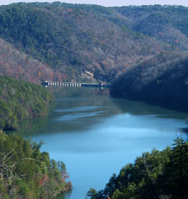
Dawson Forest - City of Atlanta Tract is a cooperative project of: Hartsfield-Jackson Atlanta International Airport, Georgia Forestry Commission, and Georgia Department of Natural Resources – Wildlife Resources Division.
It is 10,130 acres that plays a Stewardship role for by using conservation practices that minimize damage to the Forest caused by human and natural forces. The Forest produces timber, wildlife habitat, clean water into the Etowah River watershed, and many opportunities for persons to experience recreation and education.
Wildlife The Wildlife Resources Division maintains 28 wildlife food plantings and regulates all hunting on the Forest. For more information concerning the Dawson Forest Wildlife Management Area consult the Wildlife Resources Division of the Georgia Department of Natural Resources.
Recreation - Trail use is allowed by the general public as follows: a. Hiking can be done anywhere on the Forest during all times the Forest is open. There are TRAIL USE RESTRICTIONS during hunting seasons. b. Horseback riding and mountain bike (bicycle) riding are allowed on designated trails only. Riding is not allowed during firearms deer hunting days and not before 10:00 a. m. during deer archery and spring turkey hunting days. Horseback and bicycle riding are also not allowed anytime the Main Gate is closed. Vehicles towing trailers must park at the trailhead parking area near the Main Gate on Dawson Forest Road. A parking/trail user fee is required. A daily fee can be deposited in a collection tube at the trail head or an annual pass can be obtained from the DNR Wildlife Resources Division NE Georgia office. All collected funds are used in trail maintenance and management. c. No ATV or off-road vehicle use is allowed. Vehicles are restricted to open roads only. d. Primitive camping is allowed anywhere on the Forest on days it is open. Camping is restricted to seven consecutive days or less. There are no restroom or garbage collection facilities with the exception of the "dry toilet" at the trailhead. Users should practice good conservation in all outdoor activities. Anything packed in should be packed out, trash included. Note: Any organization wishing to use Dawson Forest for a group event is required to contact the Forest Manager for a special use permit.
Education - Scouting groups and other organizations are encouraged to utilize the area for outdoor education. The Georgia Forestry Commission staff is many times available to provide educational programs concerning the management of our forests. The Commission supports the idea of the growth and production of renewable resources while providing a healthy environment for people, wildlife, and plants.
Open: The Dawson Forest City of Atlanta Tract is always closed during the last two weeks of May beginning on or near May 15th.
Directions from Hwy 400: Take Hwy 400 North or Sout,h depending upon starting location to the Dawsonville Outlet mall Red Light. (Turn Left (West) if traveling North or Right (West) if traveling South onto Dawson Forest Rd.) Continue straight for approximately 3.8 miles until the intersection/stop sign. Proceed straight through intersection for approximately 1 mile to South entrance gate. Proceed through gate and Parking Area/Trailhead will be just ahead on the right.