
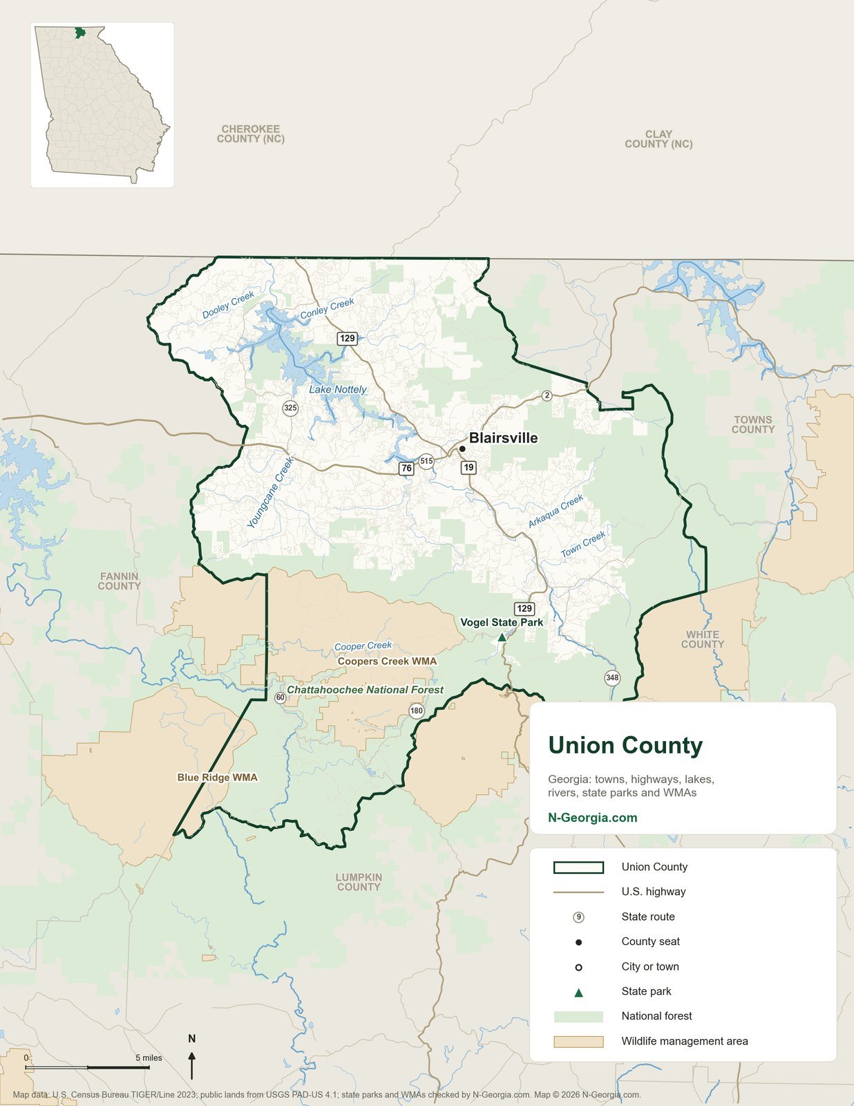
Union County is in the Northeast Georgia Mountains travel region of Georgia. Its county seat is Blairsville, and the U.S. Census Bureau estimates the county had 27,601 residents in 2024, up from 24,625 in 2020. It covers about 322 square miles of land and was created in 1832.
- County seatBlairsville
- Population (2024 estimate)27,601
- Land area322 square miles
- Created1832
- Travel regionNortheast Georgia Mountains
Print it: download the printable Union County map (PDF), sized for standard letter paper (8.5 by 11 inches, portrait). Choose “actual size” or “fit to page” when you print.
Cities and Towns in Union County
Union County has 1 incorporated city or town. Populations are U.S. Census Bureau estimates for July 1, 2024, for the whole city, including any part in a neighboring county.
| City or town | 2024 population | Note |
|---|---|---|
| Blairsville (county seat) | 849 |
Highways
Interstates and U.S. highways come from Census road data; state route numbers come from the Georgia Department of Transportation’s road inventory. In Georgia most U.S. highways also carry a state route number, and where two routes share the same road GDOT records it under one of them.
- U.S. highways: US 19, US 76, US 129
- State routes (Georgia DOT inventory numbers): SR 2, SR 11, SR 60, SR 180, SR 325, SR 348, SR 515
Parks, Public Land and Water
Public land shown on the map:
- Vogel State Park (state park)
- Coopers Creek WMA (wildlife management area)
- Blue Ridge WMA (wildlife management area)
- Chattahoochee National Forest
Lakes and rivers labeled on the map: Lake Nottely, Youngcane Creek, Cooper Creek, Town Creek, Arkaqua Creek, Dooley Creek and Conley Creek. Names follow the U.S. Geological Survey’s official Geographic Names Information System.
For county and city parks, playgrounds and recreation centers, see our Union County parks guide.
Neighboring Counties
Union County borders Fannin County, Lumpkin County, Towns County, White County, Cherokee County, NC and Clay County, NC.
Common Questions
What is the county seat of Union County, Georgia?
Blairsville is the county seat of Union County.
What cities are in Union County, Georgia?
Union County has 1 incorporated city or town: Blairsville.
What counties border Union County?
Union County borders Fannin County, Lumpkin County, Towns County, White County, Cherokee County, NC and Clay County, NC.
Is there a printable map of Union County?
Yes. The Union County map on this page is a free PDF sized for letter paper (8.5 by 11 inches, portrait) that you can print or save to your phone.
How many people live in Union County?
The U.S. Census Bureau estimates 27,601 people lived in Union County on July 1, 2024, up from 24,625 in 2020.
Sources we checked
This map and page were built in October 2026 from public data:
- U.S. Census Bureau: TIGER/Line 2023 (county lines, roads, water, place boundaries)
- U.S. Census Bureau: county and city population estimates, Vintage 2024
- U.S. Census Bureau: 2023 Gazetteer (land area)
- USGS: Protected Areas Database of the United States (PAD-US) 4.1 (national forests, refuges, WMAs)
- USGS: Geographic Names Information System (lake and river names)
- Georgia DNR 2026-27 Hunting Regulations (eRegulations) (current WMA list)