|
Off Highway Road Vehicle enthusiasts can find plenty of opportunities on Georgia's two National Forests. The Chattahoochee National Forest is in North Georgia, and the Oconee National Forest is in Central GA. Click on blue orv trails links for more info. |
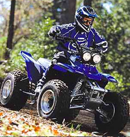
| OHVs are defined as any motorized vehicle which travels off-road for recreational purposes. OHV's include: motorbikes such as mini bikes, dirt bikes, and motor cross bikes; four-wheel drive vehicles such as jeeps, land rovers, and pickups; all-terrain vehicles such as the popular three and four-wheelers; dune buggies; and snowmobiles. U. S. Forest Service rules, regulations and safety tips. OHVs are popular with individuals and family groups that want a scenic and challenging ride within the National Forest. |
| Please click on the OHV Trail names below for dates open, pictures and more info. |
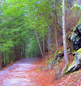
| Beasley Knob OHV Trail System - The 10.6 mile Beasley Knob OHV Trail System is a challenging trail system. It can be accessed by two trailheads. The system provides approximately 10.6 miles of recreational riding for OHV enthusiasts , including those riding four-wheel drive vehicles, motorcycles and ATVs. The system is made up of interconnecting dirt trails, rock hill climbs and gravel roads through the Chattahoochee National Forest. It is recommended for experienced riders, only, due to its challenging terrain and steep ascents. Please, no bolted, studded or tire chains allowed. The Beasley Knob Trails are open from sunrise to sunset. |
| Davenport OHV Trail System - 5.9 miles length. This trail is also suitable for ATV's and motorcycles. This trail loops around Davenport Mountain with some moderate grades, and offers views of Nottely Lake. Some areas of this trail are recommended for riders accustomed to riding on flat to rolling terrain, young, or inexperienced riders. However, there are some very difficult areas in this ATV trail as well. Cross country riding is not allowed and riders must stay on the trail. A fee is required to ride on this trail system. |
|
| Houston Valley OHV Trails - Just west of Dalton lies the largest Forest Service OHV system of trails in Georgia. These very popular motorized trails offer something for everyone, from easy to difficult, in a wooded setting. Suitable for Motorbikes and all-terrain vehicles. These trails have been designed to provide a challenging, safe ride while protecting the environment. This part of the forest offers some of the finest scenery and fun outdoor recreational activities in north GA. An ADA loading ramp and restroom available at the trailhead. Trail is open April 1 through Dec 31. Trail system closes for several days after significant rain events. Be sure to call the Conasauga Ranger District before driving to the area. |
| Oakey Mountain and Moates Knob OHV Trail System - Oakey Mountain OHV Trails area length is 9.2 miles. This 6-site developed campground near lake Burton and Lake Rabun is located only 100 yards from the trailhead, allowing for trouble-free access to the trail system directly from the campground. In addition, the convenience of camping near the trails will allow the adventure enthusiast to maximize daylight on his or her ride to the fullest. Open April 1 until Jan 1. Closed Jan-March. This trail is suitable for: Three-wheelers, Trail bikes and ATV's with less than 50"" axle width. Please contact the Chattooga River Ranger District for the latest information on trail availability due to frequent weather contingencies. |
|
| Roberts Bike Camp OHV Trails - This 8-mile trail is located north of the City of Greensboro and is part of the Town Creek OHV Trail system. Amenities are picnic tables, a vault toilet and parking. Loop A is for two wheeled vehicles only. Loop B is for ATV's and Four wheelers. Jeeps and other such UTV type vehicle are not allowed. These trails are currently open when weather is good. NOTE: Riding is not allowed when weather, including rain, snow, ice and freezing, creates conditions that causes excessive damage to trails and resources. Call before driving out. Trail is frequently closed due to rain and bad weather. |
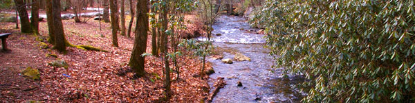
| Rock Creek ORV Trails - This 4.7 mile trail is suitable for hiking, mountain bicycles, motorcycles and ATV's. It is open all year and is Free to ride on. This is a difficult trail for biking. Beginning along the banks of Falls branch, the loop trail quickly breaks away to start its steady climb to the crest of Tatum Lead. Sections of this trail are steep and rocky. This loop trail offers a challenging riding experience through scenic terrain. Rock Creek connects with Tatum Lead ORV Trail. Trailhead has an off-loading ramp located on FS3A Peeples Lake Road. This is open all year and is Free of charge to ride on. |
| Rocky Flats OHV Trails - This 3.4 mile trail is suitable for ORVs, ATVs, 4-wheel drive vehicles, mountain bikes and hiking. It is open all year and is Free to ride on. This trail offers a challenging and safe riding experience with many sharp curves. It follows a multi-purpose woods road over piney rides and through hollows of oak and yellow poplar forest. View timber stands in various states of development. Openings in the forest canopy offer vistas of grassy Mountain. About 2.8 miles of the road on the eastern side is open to mixed traffic. Note: Due to a flood-damaged sinkhole at the gate, Rocky Flats is currently closed. Will notify you here when it is re-opened. |
|
| Tatum Lead ORV Trails - Enjoy 5.5 miles of forest trails that are suitable for mountain bicycles, motorbikes, ATVs and 4-wheel drive vehicles. The trail follows an old woods road along the ridge line of Tatum Mountain throughout dense forest. The trail dead ends to the south at a mound of direct on the government property boundary. Riding on this trail is Free, and it is open all year. |
| Town Creek OHV Trails - The Town Creek OHV Trail system is located north of the City of Greensboro Ga. The trail consists of 15 miles of trails in two loops,one for ATV's and one for motorcycles and bicycles. This double loop trail has numerous creek crossings in the rolling piedmont of middle Georgia. It starts at a hunt camp. Loop A is for two wheeled vehicles only Loop B is for ATV's and Four wheelers. Jeeps and other such UTV type vehicle are not allowed. Call before coming to this trail. |
|
| Windy Gap, Milma, Tibbs OHV Trails - These 12 miles of trails begin as a multi-purpose woods trail. They eventually change to a narrow, steep pathway as you climb 2000 feet to the top of Grassy Mountain. Trails end at an upper trailhead on Forest Service Road 68. Follow the trail up a narrow ridge line and cross a high-mountain stream to complete the trip. Much of the trail is steep, narrow and rocky. These trails are open all year and are Free to ride on. |
| Whissenhunt OHV Trail System - 11.2 miles in length with all two-way traffic trails, except for two motorcycle trails. The trails are suitable for motorcycles and ATVs. The trail system is approximately 6.0 miles north of Dahlonega, GA. Users are required to stay on the signed trails to prevent damage to the surrounding resources. Whissenhunt hours of operation are from sunrise to sunset. A fee is required to ride on this trail system. |
| Georgia OHV Rules and Regulations |
|