Discover Minnehaha Falls Waterfalls in the Northeast Georgia Mountains
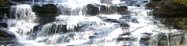
Waterfall Description: The 100-foot Minnehaha Falls is reported to be one of the most picturesque in Rabun County. It is a series of cascading falls. These falls are named for Minnehaha, a fictional character in the epic poem The Song of Hiawatha.
Natural rock benches provide an intimate view of the the water as it cascades down a stair rock formation.
I like this waterfall because it is to easy to get to. Most people from the youngest of young to the oldest of old can see this waterfall. The trail is dirt and muddy because of the falls. As you walk on the trail, you will hear the roaring of the falls from the beginning to the end. This sound adds to the excitement and peacefullness of this scenic area at the same time.
It is an easy to moderate hike.
It starts out with stairs across the street from the parking area. There is no parking fee, so it is free to visit.
The picture of the stairs below is the entrace to the waterfalls. Scratched on the stairs is "Minnihaha Falls". I call it a stairway to heaven.
Minnehaha Falls is buried in a wide, steep-sided cove packed with rhododendron, making this an exceptionally beautiful hike in mid-to-late May, when the rhododendron bloom.
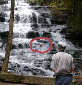
Check out the video at the bottom of this page. It features a birds' eye from the quadcopter.
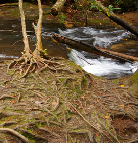
It does not take long to reach the falls because the walk is relatively short. Some waterfalls are 3 miles each way, so this is a peace of cake. The only thing is that there are lots of tree roots and rocks that are on the path. Please walk with caution and not be in a big hurry.
Dogs are welcome here. So if you're looking for a great waterfall to walk your dog to, this is it.
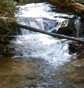
About halfway up this path are the lower falls. They are not directly on the path. You will need to take a small detour to your right (on the way to the large falls) to get to the lower falls. These lower falls are worth seeing as well.
Here's 2 pictures of the lower falls.
Just below to the left is a picture of a tree with lots of roots on a path.
GPS Location to entrance of Minnehaha Falls: N34.74955 and W083.47929
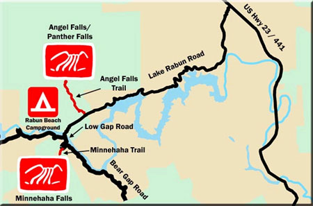
Directions: Take HWY 441 toward Clayton. After crossing the Tallulah Falls Bridge, go 1.7 miles and turn left onto Old HWY 441. Proceed 2.5 miles and turn left onto Lake Rabun Road. Travel 5 miles to Rabun Beach Campground.
From the Area 2 campground entrance, continue west on Lake Rabun Road for 1.6 miles. Turn left onto Low Gap Road for 0.2 miles. Make another left onto Bear Gap Road and proceed 1.6 miles to the Minnehaha Trail. Follow the trail 0.3 miles to the falls. Parking near the trailhead is very limited to 3-4 vehicles.
The falls can be reached by a short trail (0.4 miles) from Bear Gap Road called the Minnehaha Trail. The trail is maintained by the U.S. Forest Service.
See the video below. The quadcopter is circled in this picture. It is filming these beautiful cascading water falls.
You can see Minnehaha Falls in action. Some of the video was produced with a quadcopter.


 Waterfall Description: The 100-foot Minnehaha Falls is reported to be one of the most picturesque in Rabun County. It is a series of cascading falls. These falls are named for Minnehaha, a fictional character in the epic poem The Song of Hiawatha.
 It does not take long to reach the falls because the walk is relatively short. Some waterfalls are 3 miles each way, so this is a peace of cake. The only thing is that there are lots of tree roots and rocks that are on the path. Please walk with caution and not be in a big hurry.
 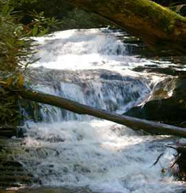 About halfway up this path are the lower falls. They are not directly on the path. You will need to take a small detour to your right (on the way to the large falls) to get to the lower falls. These lower falls are worth seeing as well.