Big Frog Wilderness Area - The U.S. Congress designated the Big Frog Wilderness in 1984 and it now has a total of 8,082 acres.
Georgia contains approximately 89 acres and Tennessee contains approxroximately 7,993 acres. It is managed by the Forest Service. Big Frog Wilderness is bordered by the Cohutta Wilderness to the southwest. If you like the notion of crossing state lines on foot, take the steep 6.2-mile Hemp Top Trail from Cohutta Wilderness in Georgia, near the western boundary of Big Frog, until it dead-ends at Tennessee's Licklog Ridge Trail. If you want to keep hiking, the Licklog Ridge Trail is easy to access.
Blood Mountain Wilderness - The U.S. Congress designated the Blood Mountain Wilderness in 1991 and it now has a total of 7,800 acres.
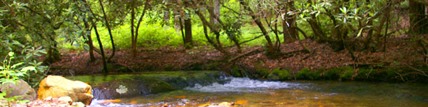
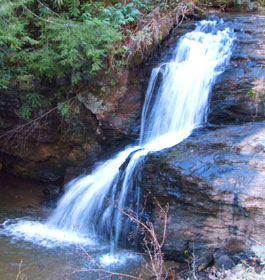
All of this wilderness is located in Georgia and is managed by the Forest Service. Legends tell of the gory battles waged between Creek and Cherokee Indians atop 4,458-foot Blood Mountain, but today the site is famous for being the highest point in this Wilderness. Scenically rugged mountain peaks, rocky outcroppings, waterfalls, and numerous streams (offering 27 miles of trout fishing), all of which lie within the Chestatee Wildlife Management Area, surround the mountain.
Brasstown Wilderness - The U.S. Congress designated the Brasstown Wilderness in 1986 and it now has a total of 12,896 acres. All of this wilderness is located in Georgia and is managed by the Forest Service. The "capital of the Cherokee" is a steeply rugged Wilderness that drapes across the northern, northeastern, and southwestern flanks of 4,784-foot Brasstown Bald Mountain, the highest point in the state.
Here you'll find boulder fields, rock formations, and streams cascading through narrow gorges, giving way periodically to waterfalls. Second-growth hardwoods dominate this flora-rich region, highlighted in spring and summer by a profusion of wildflowers.
Cohutta Wilderness - The U.S. Congress designated the Cohutta Wilderness (map) in 1975 and it now has a total of 36,977 acres. Georgia contains approximately 35,268 acres. Tennessee contains approximately 1,709 acres. It is managed by the Forest Service. The Cohutta Wilderness is bordered by the Big Frog Wilderness to the northeast.
Most of mountainous Cohutta, the state's second largest Wilderness, lies in Georgia and within the Cohutta Wildlife Management Area. But a small portion runs over the border into Tennessee . Although loggers worked their way through 70 percent of the forest between 1915 and 1930, oak and pine have all but reclaimed the forest, and a rich growth of hardwoods now fills out the lower elevations: magnolia, maple, buckeye, hornbeam, sassafras, holly, silver bell dogwood, and chestnut, to name but a few.
Ellicott Rock Wilderness - The U. S. Congress designated the Ellicott Rock Wilderness in 1975 and it now has a total of 8,274 acres. Georgia contains approximately 2,021 acres. North Carolina contains approximately 3,394 acres. South Carolina contains approximately 2,859 acres.
The Georgia terrain peaks at 3,672-foot Glade Mountain. Clear perennial trout streams that occasionally drop over small waterfalls scour the numerous steep-walled gorges. Unusual rock formations hover above some of the streams, and several threatened or endangered plants have been identified.
Mark Trail Wilderness - The U.S. Congress designated the Mark Trail Wilderness in 1991 and it now has a total of 16,400 acres. All of this wilderness is located in Georgia and is managed by the Forest Service. Mark Trail Wilderness is bordered by the Raven Cliffs Wilderness to the south.
The logging roads that once ran along the streams, waterfalls, rocky outcroppings, and high peaks that distinguish the Chattahoochee Wildlife Management Area are rapidly returning to their natural state. The mountains (Horsetrough is the highest at 4,045 feet) are covered in second-growth upland and cove hardwoods in over 60 years of age.
Raven Cliffs Wilderness - The U.S. Congress designated the Raven Cliffs Wilderness in 1986 and it now has a total of 9,115 acres. All of this wilderness is located in GA and is managed by the Forest Service. The Raven Cliffs Wilderness is bordered by the Mark Trail Wilderness to the north.
Numerous streams and waterfalls, high peaks, and rocky outcroppings combine to create a rugged mountain Wilderness divided between the Chestatee and Chatta-hoochee Wildlife Management Areas. Elevations range from about 1,800 feet on Boggs Creek to 3,846 feet on Leveland Mountain. A dense forest of hardwoods and scattered pines has recovered from substantial logging operations early in this century--most of the trees have now celebrated their 60th birthday.
Rich Mountain Wilderness - The U.S. Congress designated the Rich Mountain Wilderness in 1986 and it now has a total of 9,476 acres. All of this wilderness is located in Georgia and is managed by the Forest Service.
At 4,050 feet, Rich Mountain anchors an area that includes several threatened and endangered plants and numerous species considered rare in Georgia. About 30 miles of trout streams and waterfalls embellish the rocky outcroppings in this rugged, mountainous terrain.
Southern Nantahala Wilderness - The U.S. Congress designated the Southern Nantahala Wilderness in 1984 and it now is 23,473 acres. Georgia contains approximately 11,770 acres. North Carolina contains approximately 11,703 acres. It is managed by the Forest Service.
Steep, rugged, reforested country cut by numerous streams and old drainages characterizes the southern end of the Blue Ridge Mountains. The streams feed the Nantahala, Hiwassee, and Tallulah Rivers, and the wide non-Wilderness right-of-way along the Tallulah neatly divides the Georgia share of the wildland.
Tray Mountain Wilderness - The U.S. Congress designated the Tray Mountain Wilderness in 1986 and it now has a total of 9,702 acres. All of this wilderness is located in Georgia and is managed by the Forest Service.
At 4,430 feet, Tray Mountain dominates the southern portion of this rugged Wilderness, which straddles the crest of the Blue Ridge. From up high, fast-flowing streams tumble down narrow gorges and over many waterfalls. Second-growth hardwoods at least 60 years old are the primary forest cover.
Are you ready for a wilderness experience? - Be prepared! Perhaps the most important part of your wilderness trip will be the time spent at home planning, provisioning, and practicing. Know when hunting seasons are open. The Wilderness is a primitive environment where you will be faced with the challenge of being entirely self-sufficient. There will be no shelters, campgrounds, drinking fountains, or restrooms. Only foot travel is permitted. Horses and pack stock are allowed only on selected trails. You will meet nature on its own terms away from the comforts of civilization. Check out how to prepare for a fun wilderness experience.