Visit Cohutta Wilderness U.S. Forest Area -Stay and Play in GA!
Cohutta Wilderness is 36,977 acres. 35,268 acres are in Georgia. TN contains 1,709 acres.
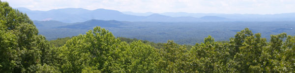
Description - Most of mountainous Cohutta, the state's second largest Wilderness, lies in Georgia and within the Cohutta Wildlife Management Area. But a small portion runs over the border into Tennessee (see Tennessee, Cohutta Wilderness).
Although loggers worked their way through 70 percent of the forest between 1915 and 1930, oak and pine have all but reclaimed the forest, and a rich growth of hardwoods now fills out the lower elevations: magnolia, maple, buckeye, hornbeam, sassafras, holly, silver bell dogwood, and chestnut, to name but a few.
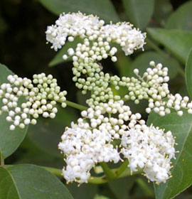
Spring and summer bring colorful blooms to many shrubs, vines, and herbaceous plants, ranging from the brilliant orange of flame azalea to the pink and yellow of lady's slippers, the blue cohosh, and the scarlet cardinal flower. But summer also means heat and high humidity, biting insects, and foliage so dense it blocks some views that are truly spectacular in fall and spring.
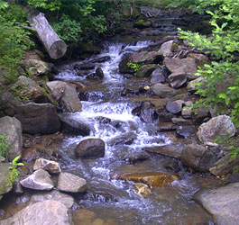
The Conasauga and Jacks Rivers, two of the state's most prolific trout streams, drop through rocky gorges and flash flood the Wilderness during periods of heavy rain. Anglers can try hooking trout in the many streams, too, while hunters train their sights on white-tailed deer, black bears, and wild boars. More than 100 bird species have been identified in the area (situated along the Appalachian Flyway), along with copperheads, timber rattlesnakes, and other slithering species.
Popular trails follow both the Conasauga and Jacks Rivers, and at least a dozen other footpaths provide access to the Wilderness. Many of the trails require wading through waterways. The 15.7-mile Jacks River Trail, for instance, passes through water no less than 40 times. The colorful blazes that mark most of the trails are easy to follow, even in soggy shoes.
If you're looking for a trail with lighter foot traffic, try the seldom used (except in hunting season) Hickory Creek Trail (8.4 miles), the more strenuous Tearbritches Trail (3.4 miles), or the East Cowpen Trail (seven miles). All three gain a fair amount of elevation and provide excellent views. There's also the 6.2-mile Hemp Top Trail, which connects with the Licklog Ridge Trail on the Tennessee side of the Wilderness. Horses are allowed on many but not all of the trails; contact the district ranger for information.
Contact: Armuchee-Cohutta Ranger District - Phone: 706-695-6736
Tennessee Entry:
Most of mountainous Cohutta lies within Tennessee's Cohutta Wildlife Management Area, but a small portion runs over the southern border (see Georgia, Cohutta Wilderness). Immediately northeast of Tennessee's portion, and sharing a border, lies Big Frog Wilderness (see above). Cohutta and Big Frog combine with 1,460 acres of the West Big Frog Primitive Area bordering Cohutta on the north to form the largest tract of Wilderness on national forest land in the eastern United States.
Although timber companies made off with 70 percent of the trees between 1915 and 1930--evidence of logging is apparent in a few spots. Oak and pine have returned and now blanket the forest. Virginia pine thickly dominate the forest floor at lower elevations, deferring to upland hardwoods that include hickory, red oak, and white oak. Beech, basswood, birch, red maple, black gum, and silver bell shade four species of plants designated rare in this region: catchfly, purple hyssop, cow parsnip, and rattlesnake root.
Spring and summer bring of colorful blooms to many flowering shrubs, vines, and herbaceous plants, including the brilliant orange of flame azalea, the pink and yellow of lady's slippers, the blue cohosh, and the scarlet cardinal flower.
But summer also brings heat, high humidity, biting insects, and heavy foliage blocking some of the must-see fall and spring views. You may glimpse domestic hogs gone wild, as well as wild turkeys and bobcats. Many species of snakes, including unusually large copperheads and timber rattlesnakes lurk in the shadows.
One short piece of Trail 74 crosses the Tennessee portion for less than one-half mile, with junctions onto Georgia's Jacks River Trail and onto trails leading into Big Frog Wilderness. To explore most of this small piece of Tennessee, you will have to wander off-trail.
Area Management
The Cohutta Wilderness is part of the 109 million acre National Wilderness Preservation System. This System of lands provides clean air, water, and habitat critical for rare and endangered plants and animals. In wilderness, you can enjoy challenging recreational activities like hiking, backpacking, climbing, kayaking, canoeing, rafting, horse packing, bird watching, stargazing, and extraordinary opportunities for solitude.
You play an important role in helping to "secure for the American people of present and future generations the benefits of an enduring resource of wilderness" as called for by the Congress of the United States through the Wilderness Act of 1964.
Please follow the requirements outlined below and use Leave No Trace techniques when visiting the Brasstown Wilderness to ensure protection of this unique area.
General Wilderness Prohibitions
Motorized equipment and equipment used for mechanical transport is generally prohibited on all federal lands designated as wilderness. This includes the use of motor vehicles, motorboats, motorized equipment, bicycles, hang gliders, wagons, carts, portage wheels, and the landing of aircraft including helicopters, unless provided for in specific legislation.
In a few areas some exceptions allowing the use of motorized equipment or mechanical transport are described in the special regulations in effect for a specific area. Contact the Forest Service office for more specific information.
These general prohibitions have been implemented for all national forest wildernesses in order to implement the provisions of the Wilderness Act of 1964. The Wilderness Act requires management of human-caused impacts and protection of the area's wilderness character to insure that it is "unimpaired for the future use and enjoyment as wilderness." Use of the equipment listed as prohibited in wilderness is inconsistent with the provision in the Wilderness Act which mandates opportunities for solitude or primitive recreation and that wilderness is a place that is in contrast with areas where people and their works are dominant.
Wilderness-Specific Regulations
Wilderness managers often need to take action to limit the impacts caused by visitor activities in order to protect the natural conditions of wilderness as required by the Wilderness Act of 1964. Managers typically implement 'indirect' types of actions such as information and education measures before selecting more restrictive measures. When regulations are necessary, they are implemented with the specific intent of balancing the need to preserve the character of the wilderness while providing for the use and enjoyment of wilderness.
The following wilderness regulations are in effect for this area. Not all regulations are in effect for every wilderness. Contact the Forest Service office for more specific information about the regulations listed.
Being in the Jacks Falls River area after sundown or before sunrise, except from Nov 1 through March 31. This area is defined as the area within 300 feet of The Jacks River Falls, the area within 300 feet of Beech creek, from the intersection of Beech Creek with Beach Bottom Trail downstream to the intersection of Beech Creek with Jacks River, or the area within 300 feet of the Jacks River Trail's first river crossing above the Jacks River Falls to the Jacks River Trail's first river crossing below the Jacks River Falls, and the area of land bounded by Beech Creek, Beech Bottom Trail and Jacks River.
Bottles and cans prohibited
Possessing a beverage which is defined as an alcoholic beverage by GA state law in the Jacks River Falls Area is prohibited. This area is defined as the area within 300 feet of the Jacks River Falls, the area within 300 feet of Beech Creek, from the intersection of Beech Creek with Beach Bottom Trail downstream to the intersection of Beech Creek with Jacks River, or the area within 300 feet of the Jacks River Trail's first river crossing above the Jacks River Falls to the Jacks River Trail's first river corssing below the Jacks River Falls, and the area of land bounded by Beech Creek, Beech Bottom Trail and Jacks River.
Campfires Prohibited
Building, maintaining, attending, or using a fire, campfire, or stove fire in the Jacks River Falls Area is prohibited. This area is defined as the area within 300 feet of the Jacks River Falls, the area within 300 feet of Beech Creek, from the intersection of Beech Creek with Beach Bottom Trail downstream to the intersection of Beech Creek with Jacks River, or the area within 300 feet of the Jacks River Trail's first river crossing above the Jacks River Falls to the Jacks River Trail's first river corssing below the Jacks River Falls, and the area of land bounded by Beech Creek, Beech Bottom Trail and Jacks River.
Campsite Restriction - In designated sites only 151 DAYS
Camping in the Jacks River Area is prohibited, except camping at designated campsites in the Beech Bottom Area from November 1 through March 31. This area is defined as the area within 300 feet of the Jacks River Falls, the area within 300 feet of Beech Creek, from the intersection of Beech Creek with Beach Bottom Trail downstream to the intersection of Beech Creek with Jacks River, or the area within 300 feet of the Jacks River Trail's first river crossing above the Jacks River Falls to the Jacks River Trail's first river corssing below the Jacks River Falls, and the area of land bounded by Beech Creek, Beech Bottom Trail and Jacks River.
Dogs Restricted to leashed and under control. Dogs must be on leash at all times. Proper food storage required Stock use prohibited
Possessing or using a saddle, pack, or draft animal on developed trails which has been closed to use by horses and so posted is prohibited.
Within Chattahoochee-Oconee National Forest Land Managment Plan, horses are prohibed on the Conasauga River Trail, Rough Ridge Trail, Panther Creek Trail, Sugar Cive Trail, Chestnut Lead Trail, Tear Britches Trail, Horse Shoe Trail-North 1 Mile, Jacks River-Allowed only between Beech Bottom/Penitentiary Branch, Benton Mackaye-prohibited on trail except where Hemptop and Benton Mackaye Trails share the same tread for a short distance. This is outlined in the forest plan.
Stock use restriction - No Hitching or Tethering
Hitching, Tethering or Hobbling a horse or other saddle or pack animal closer than 50 feet from a streamor body of water is prohibited.
The priority for the Forest Service during the 1960's and 1970's was to restore badly eroded lands on the Oconee and restore forest health. During the 1960's construction efforts were undertaken to provide developed recreation areas within 50 miles of every major town. Brasstown Bald Visitor Information Center atop Georgia's highest mountain and Warwomen Dell are examples of areas built as a result of this effort.
The next four decades saw increased environmental legislation that governs management of the national forests to protect environmental quality and insure public involvement in the process. Wilderness areas were preserved, Wild and Scenic Rivers designated, and experts in natural resource management were employed to help meet the challenges. While the way we do things have changed many times over the years, our tradition of stewardship--caring for the land and serving people, is the same.


 Description