Discover U.S. Forest Ellicott Rock Wilderness Area - It now has a total of 8,274 acres. Georgia has 2,021 acres. North Carolina contains 3,394 acres. South Carolina contains 2,859 acres. It is managed by the U. S. Forest Service.
Description
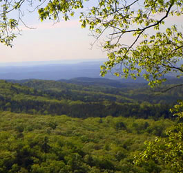
Rugged terrain, tall peaks, and the Wild and Scenic Chattooga River are the hallmarks of this Wilderness, which is shared by three states (see North Carolina, Ellicott Rock Wilderness; and South Carolina, Ellicott Rock Wilderness). Offering one of the foremost white-water trips in the eastern United States, the Chattooga floods through the middle of the area, but the wildest water lies below the Wilderness boundary, where boating is not allowed.
The Georgia terrain peaks at 3,672-foot Glade Mountain. Clear perennial trout streams that occasionally drop over small waterfalls scour the numerous steep-walled gorges. Unusual rock formations hover above some of the streams, and several threatened or endangered plants have been identified.
Although logging operations intruded in the early 1900s (as evidence attests), today's forest of hardwoods (upland and cove) is more than 80 years old. Deer, squirrels, grouse, and wild turkeys are common sights in the Georgia portion of the Wilderness, along with the more elusive black bear and raccoon. Wild boars wander in from North Carolina now and then. You may see the remains of the old moonshine stills that once brewed their potions here.
South Carolina Entry:
In 1811, surveyor Andrew Ellicott determined the starting point for the North Carolina-Georgia state line and chiseled an inconspicuous mark on a rock on the east bank of the Chattooga River.
Here the mountainous regions of South Carolina, North Carolina, and Georgia converge, and this is where the Ellicott Rock Wilderness straddles the Wild and Scenic Chattooga River. This is the only Wilderness area lying in three states (see the Ellicott Rock Wildernesses in Georgia and North Carolina). Unlike many pristine areas in the western United States (but like many other southeastern Wildernesses), Ellicott Rock has been heavily impacted by humans in the not too distant past. Nevertheless, enough time has passed since the logging operations of yesteryear for impressive second-growth forests, typical of the Appalachian greenbelt, to reclaim Ellicott Rock Wilderness.
Today dense stands of white pine and hemlock occupy the lower coves and areas along streams, upland hardwoods thrive on slopes, and scrub oaks and pitch pines grow on dry ridges. The region lies just south of the area that receives the highest rainfall in the eastern United States; expect some wet weather.
In South Carolina, the Wilderness rises from the river to a high point on Fork Mountain at 3,294 feet. Several trails originate in the South Carolina portion. From the Sloan Bridge Picnic Area on the eastern border, 6.3 miles of the Ellicott Rock Trail will take you down to Ellicott Rock itself. This trail joins the Chattooga River Trail, which follows the South Carolina side of the river south for 4.4 miles to Burrell's Ford Campground. Ellicott Rock stands relatively near millions of Americans, and use of the area is high. Along the river you'll find more solitude.
Contact: Andrew Pickens Ranger District - Phone: 864-638-9568 Address: 112 Andrew Pickens Circle, Mountain Rest, SC 29664 Restrictions: Office hours: 8 AM - 4:30 PM
North Carolina Entry:
This is America's only designated Wilderness to extend into three states (see Georgia and South Carolina, Ellicott Rock Wilderness). In North Carolina, the bowl-shaped Wilderness drops to the Wild and Scenic Chattooga River and attracts numerous visitors, most of whom have yet to grasp or appreciate the principles of Leave No Trace. The dense overstory vegetation may appear virgin to the uninformed.
Although the area is rugged and mountainous, trails to the river are relatively easy going in, more strenuous coming back out, and day hiking constitutes the main human use. Ellicott Rock Trail typifies the footpaths. It follows an abandoned road from a parking lot for two miles before gently dropping into the Wilderness, then follows the old road another mile before bearing left steeply down one-half mile to the Chattooga River and Ellicott Rock. This site bears the inconspicuous mark of Andrew Ellicott, the surveyor who in 1811 determined the border between Georgia and North Carolina.
Area Management
The Ellicott Rock Wilderness is part of the 109 million acre National Wilderness Preservation System. This System of lands provides clean air, water, and habitat critical for rare and endangered plants and animals. In wilderness, you can enjoy challenging recreational activities like hiking, backpacking, climbing, kayaking, canoeing, rafting, horse packing, bird watching, stargazing, and extraordinary opportunities for solitude.
You play an important role in helping to "secure for the American people of present and future generations the benefits of an enduring resource of wilderness" as called for by the Congress of the United States through the Wilderness Act of 1964.
Please follow the requirements outlined below and use Leave No Trace techniques when visiting the Brasstown Wilderness to ensure protection of this unique area.
General Wilderness Prohibitions
Motorized equipment and equipment used for mechanical transport is generally prohibited on all federal lands designated as wilderness. This includes the use of motor vehicles, motorboats, motorized equipment, bicycles, hang gliders, wagons, carts, portage wheels, and the landing of aircraft including helicopters, unless provided for in specific legislation.
In a few areas some exceptions allowing the use of motorized equipment or mechanical transport are described in the special regulations in effect for a specific area. Contact the Forest Service office for more specific information.
These general prohibitions have been implemented for all national forest wildernesses in order to implement the provisions of the Wilderness Act of 1964. The Wilderness Act requires management of human-caused impacts and protection of the area's wilderness character to insure that it is "unimpaired for the future use and enjoyment as wilderness." Use of the equipment listed as prohibited in wilderness is inconsistent with the provision in the Wilderness Act which mandates opportunities for solitude or primitive recreation and that wilderness is a place that is in contrast with areas where people and their works are dominant.
Wilderness-Specific Regulations
Wilderness managers often need to take action to limit the impacts caused by visitor activities in order to protect the natural conditions of wilderness as required by the Wilderness Act of 1964. Managers typically implement 'indirect' types of actions such as information and education measures before selecting more restrictive measures. When regulations are necessary, they are implemented with the specific intent of balancing the need to preserve the character of the wilderness while providing for the use and enjoyment of wilderness.
The following wilderness regulations are in effect for this area. Not all regulations are in effect for every wilderness. Contact the Forest Service office for more specific information about the regulations listed.
Building, maintaining, attending or using a fire, campfire, or stove fire within 50 feet of the Chattooga River or any of its tributaries within the wild and scenic river corridor is prohibited. Campsite Restriction - In designated sites only - 1320 feet Camping within one quarter mile of any roadway is prohibited within the wild and scenic river corridor. Campsite Restriction - In designated sites only - 50 feet Campfires Prohibited - 50 feet Camping within 50 feet of any maintained tril is prohibited within the wild and scenic river corridor. Camping within 50 feet of the Chattooga River or any of its tributaries within the wild and scenic river corridor is prohibited. Maximum Overnight Group Site for 12 campers only Maximum Length of Stay is 14 DAYS
The priority for the Forest Service during the 1960's and 1970's was to restore badly eroded lands on the Oconee and restore forest health. During the 1960's construction efforts were undertaken to provide developed recreation areas within 50 miles of every major town. Brasstown Bald Visitor Information Center atop Georgia's highest mountain and Warwomen Dell are examples of areas built as a result of this effort.
The next four decades saw increased environmental legislation that governs management of the national forests to protect environmental quality and insure public involvement in the process. Wilderness areas were preserved, Wild and Scenic Rivers designated, and experts in natural resource management were employed to help meet the challenges. While the way we do things have changed many times over the years, our tradition of stewardship--caring for the land and serving people, is the same.