Discover U.S. Forest Tray Mountain Wilderness Area - The U. S. Congress designated the Tray Mountain Wilderness in 1986 and it now has a total of 9,702 acres. All of this wilderness is located in Georgia and is managed by the Forest Service. Stay and Play in GA!
Mountain Wilderness Description
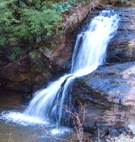
At 4,430 feet, Tray Mountain dominates the southern portion of this rugged Wilderness, which straddles the crest of the Blue Ridge. From up high, fast-flowing streams tumble down narrow gorges and over many waterfalls. Second-growth hardwoods at least 60 years old are the primary forest cover. Deer, squirrels, grouse, and wild turkeys make common appearances, along with the ever-elusive black bear, raccoons, doves, quail, and woodcocks. About 41 miles of trout streams produce rainbows and browns. You'll see remnants of past logging operations, mostly abandoned roads. Just across State Highway 75 lies Mark Trail Wilderness.
The Appalachian Trail (AT) follows the crest of the Blue Ridge for 16.5 unusually level miles from Unicoi Gap to Dick's Creek Gap, with a shelter at Tray Mountain. The High Shoals Trail leads about 1.5 miles to the High Shoals Scenic Area, where a waterfall drops over dramatic cliffs. Hunters and anglers come often to this area, but the AT attracts the most visitors.
Contact - Chattooga Ranger District - Phone: 706-754-6221 Address: 200 Hwy 197 N, Clarkesville, GA 30523
Area Management
The Tray Mountain Wilderness is part of the 109 million acre National Wilderness Preservation System. This System of lands provides clean air, water, and habitat critical for rare and endangered plants and animals. In wilderness, you can enjoy challenging recreational activities like hiking, backpacking, climbing, kayaking, canoeing, rafting, horse packing, bird watching, stargazing, and extraordinary opportunities for solitude.
You play an important role in helping to "secure for the American people of present and future generations the benefits of an enduring resource of wilderness" as called for by the Congress of the United States through the Wilderness Act of 1964.
Please follow the requirements outlined below and use Leave No Trace techniques when visiting the Brasstown Wilderness to ensure protection of this unique area.
General Wilderness Prohibitions
Motorized equipment and equipment used for mechanical transport is generally prohibited on all federal lands designated as wilderness. This includes the use of motor vehicles, motorboats, motorized equipment, bicycles, hang gliders, wagons, carts, portage wheels, and the landing of aircraft including helicopters, unless provided for in specific legislation.
In a few areas some exceptions allowing the use of motorized equipment or mechanical transport are described in the special regulations in effect for a specific area. Contact the Forest Service office for more specific information.
These general prohibitions have been implemented for all national forest wildernesses in order to implement the provisions of the Wilderness Act of 1964. The Wilderness Act requires management of human-caused impacts and protection of the area's wilderness character to insure that it is "unimpaired for the future use and enjoyment as wilderness." Use of the equipment listed as prohibited in wilderness is inconsistent with the provision in the Wilderness Act which mandates opportunities for solitude or primitive recreation and that wilderness is a place that is in contrast with areas where people and their works are dominant.
Wilderness-Specific Regulations
Wilderness managers often need to take action to limit the impacts caused by visitor activities in order to protect the natural conditions of wilderness as required by the Wilderness Act of 1964. Managers typically implement 'indirect' types of actions such as information and education measures before selecting more restrictive measures. When regulations are necessary, they are implemented with the specific intent of balancing the need to preserve the character of the wilderness while providing for the use and enjoyment of wilderness.
The following wilderness regulations are in effect for this area. Not all regulations are in effect for every wilderness. Contact the Forest Service office for more specific information about the regulations listed.
Dogs Restricted - Leased-Under Control Pets must be on a leash at all times.
Stock use restriction - No Hitching or Tethering Hitching, tethering or hobbling a horse or other saddle or pack animal closer than 50 feet from a stream or body of water is prohibited, possessing or using a saddle, pack or draft animal on developed trails which has been closed to use by horses and so posted as prohibited.
The priority for the Forest Service during the 1960's and 1970's was to restore badly eroded lands on the Oconee and restore forest health. During the 1960's construction efforts were undertaken to provide developed recreation areas within 50 miles of every major town. Brasstown Bald Visitor Information Center atop Georgia's highest mountain and Warwomen Dell are examples of areas built as a result of this effort.
The next four decades saw increased environmental legislation that governs management of the national forests to protect environmental quality and insure public involvement in the process. Wilderness areas were preserved, Wild and Scenic Rivers designated, and experts in natural resource management were employed to help meet the challenges. While the way we do things have changed many times over the years, our tradition of stewardship--caring for the land and serving people, is the same.