Discover U.S. Forest Southern Natahala Wilderness Area - This wilderness has a total of 23,473 acres. Georgia has 11,770 acres. North Carolina has 11,703 acres. It is managed by the Forest Service.Stay and Play in GA!
Description
After the Cherokee were removed from their "Great Blue Hills of God" (the Blue Ridge Mountains), loggers stripped the trees from the land and shipped them out via the railway. The main line of that railway ran along the Nantahala River, and evidence of it still exists in a Wilderness shared by Georgia and North Carolina (see North Carolina, Southern Nantahala Wilderness).
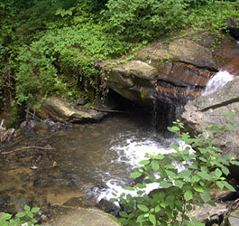
Steep, rugged, reforested country cut by numerous streams and old drainages characterizes the southern end of the Blue Ridge Mountains. The streams feed the Nantahala, Hiwassee, and Tallulah Rivers, and the wide non-Wilderness right-of-way along the Tallulah neatly divides the Georgia share of the wildland. The eastern section is the northern portion of Georgia's Coleman River Wildlife Management Area.
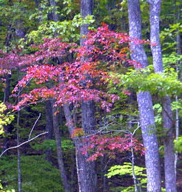
In both sections spruce and fir cover the ridges (opened by grass-heath "balds") and mixed hardwoods grow on the slopes. Elevations here are lower than in Tennessee. Several unique bogs support endangered species such as the bog turtle and rare combinations of other species found nowhere else in the world.
Other than four miles of the Appalachian Trail, which runs north-south through the larger western section, you won't find developed pathways on the Georgia side. However, old roadbeds provide hiking access. Off these old roads and deep in the shade of the many trees, where the walking is difficult, you'll find Georgia at her most unspoiled.
North Carolina Entry:
The Cherokee Indians thought of the Blue Ridge Mountains as the Great Blue Hills of God. These original inhabitants named the shady forests and deep, dark gorges Nantahala, or Land of the Noonday Sun. Later settlers saw this same area as fodder for their mills. They removed virtually every piece of good timber that was at least 15 inches in diameter from the main drainages of the southern end of the Blue Ridge Mountains, what is today Southern Nantahala Wilderness and shared by North Carolina and Georgia (see Georgia, Southern Nantahala Wilderness). It is a land characterized by steep, rugged terrain dissected by many streams and old drainages. Numerous peaks exceed 4,000 feet. Streams feed into one of three rivers: the Nantahala, the Tallulah, and the Hiwassee. Now regrown, the forest cover is lush with spruce and fir on the ridges, broken by grass-heath "balds" and mixed hardwoods lower down.
>Almost all of the developed trails are steep and strenuous, with a rough tread that is sometimes a challenge to find. But few places in the southern United States offer such outstanding backpacking opportunities. Many people wander into the area from the popular adjacent Standing Indian Basin. Thirty-two miles of the Appalachian Trail (AT) pass through the Southern Nantahala, following the ridge crest of the Nantahala Range. In addition to the AT, the most used trails are the Lower Ridge Trail (4.1 miles), Big Indian Loop (8 miles), and Beech Gap (2.8 miles), but I have hiked here in the chill of January in utter silence, seeing nary another human.
Area Management
The Southern Nantahala Wilderness is part of the 109 million acre National Wilderness Preservation System. This System of lands provides clean air, water, and habitat critical for rare and endangered plants and animals. In wilderness, you can enjoy challenging recreational activities like hiking, backpacking, climbing, kayaking, canoeing, rafting, horse packing, bird watching, stargazing, and extraordinary opportunities for solitude.
You play an important role in helping to "secure for the American people of present and future generations the benefits of an enduring resource of wilderness" as called for by the Congress of the United States through the Wilderness Act of 1964.
Please follow the requirements outlined below and use Leave No Trace techniques when visiting the Brasstown Wilderness to ensure protection of this unique area.
General Wilderness Prohibitions
Motorized equipment and equipment used for mechanical transport is generally prohibited on all federal lands designated as wilderness. This includes the use of motor vehicles, motorboats, motorized equipment, bicycles, hang gliders, wagons, carts, portage wheels, and the landing of aircraft including helicopters, unless provided for in specific legislation.
In a few areas some exceptions allowing the use of motorized equipment or mechanical transport are described in the special regulations in effect for a specific area. Contact the Forest Service office for more specific information.
These general prohibitions have been implemented for all national forest wildernesses in order to implement the provisions of the Wilderness Act of 1964. The Wilderness Act requires management of human-caused impacts and protection of the area's wilderness character to insure that it is "unimpaired for the future use and enjoyment as wilderness." Use of the equipment listed as prohibited in wilderness is inconsistent with the provision in the Wilderness Act which mandates opportunities for solitude or primitive recreation and that wilderness is a place that is in contrast with areas where people and their works are dominant.
Wilderness-Specific Regulations
Wilderness managers often need to take action to limit the impacts caused by visitor activities in order to protect the natural conditions of wilderness as required by the Wilderness Act of 1964. Managers typically implement 'indirect' types of actions such as information and education measures before selecting more restrictive measures. When regulations are necessary, they are implemented with the specific intent of balancing the need to preserve the character of the wilderness while providing for the use and enjoyment of wilderness.
The following wilderness regulations are in effect for this area. Not all regulations are in effect for every wilderness. Contact the Forest Service office for more specific information about the regulations listed.
Dogs Restricted - Leased-Under Control Pets must be on a leash at all times.
Outfitter guide or other special use permits granted by Chattahoochee-Oconee National Forest for use in wilderness areas. Campsite Restriction - In designated sites only
Maximum Group Size: 10 Members Maximum Length of Stay: 14 DAYS
The priority for the Forest Service during the 1960's and 1970's was to restore badly eroded lands on the Oconee and restore forest health. During the 1960's construction efforts were undertaken to provide developed recreation areas within 50 miles of every major town. Brasstown Bald Visitor Information Center atop Georgia's highest mountain and Warwomen Dell are examples of areas built as a result of this effort.
The next four decades saw increased environmental legislation that governs management of the national forests to protect environmental quality and insure public involvement in the process. Wilderness areas were preserved, Wild and Scenic Rivers designated, and experts in natural resource management were employed to help meet the challenges. While the way we do things have changed many times over the years, our tradition of stewardship--caring for the land and serving people, is the same.