Discover U.S. Forest Blood Mountain Wilderness Area - The United States Congress designated the Blood Mountain Wilderness (map) in 1991 and it now has a total of 7,800 acres. All of this wilderness is located in Georgia and is managed by the Forest Service. Stay and Play in GA!
Description
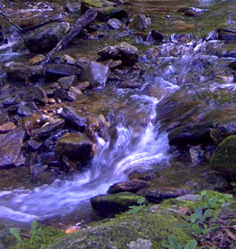
Legends tell of the gory battles waged between Creek and Cherokee Indians atop 4,458-foot Blood Mountain, but today the site is famous for being the highest point in this Wilderness. Scenically rugged mountain peaks, rocky outcroppings, waterfalls, and numerous streams (offering 27 miles of trout fishing), all of which lie within the Chestatee Wildlife Management Area, surround the mountain.
Vegetation is primarily second-growth upland and cove hardwoods, a forest that's only about 60 years old. Deer, grouse, wild turkeys, and squirrels live here in abundance. There are also black bears and raccoons, although in lesser numbers. The Desoto Falls Scenic Area, with its high vista points and waterfalls, marks the boundary. Just across U.S. 129 lies Raven Cliffs Wilderness.
Small and big game bring in quite a few hunters, and trout fishing, especially in Dick's Creek and the region north and east of Lake Winfield Scott, attracts their tackle box-toting counterparts. Hikers usually travel the Appalachian Trail (AT), which crosses the area along the crest of the Blue Ridge for 10.75 miles and eventually reaches a rock shelter on Blood Mountain. This trail, according to the USFS, is "the most heavily used portion of the AT in Georgia." Many old logging roads crisscross the area. The Duncan Ridge National Recreation Trail crosses part of the area.
Area Management
Blood Mountain Wilderness is part of the 109 million acre National Wilderness Preservation System.
This System of lands provides clean air, water, and habitat critical for rare and endangered plants and animals. In wilderness, you can enjoy challenging recreational activities like hiking, backpacking, climbing, kayaking, canoeing, rafting, horse packing, bird watching, stargazing, and extraordinary opportunities for solitude. You play an important role in helping to "secure for the American people of present and future generations the benefits of an enduring resource of wilderness" as called for by the U.S. Congress through the Wilderness Act of 1964.
Please follow the requirements outlined below and use Leave No Trace techniques when visiting the Blood Mountain Wilderness to ensure protection of this unique area.
General Wilderness Prohibitions
Motorized equipment and equipment used for mechanical transport is generally prohibited on all federal lands designated as wilderness. This includes the use of motor vehicles, motorboats, motorized equipment, bicycles, hang gliders, wagons, carts, portage wheels, and the landing of aircraft including helicopters, unless provided for in specific legislation.
In a few areas some exceptions allowing the use of motorized equipment or mechanical transport are described in the special regulations in effect for a specific area. Contact the Forest Service office for more specific information.
These general prohibitions have been implemented for all national forest wildernesses in order to implement the provisions of the Wilderness Act of 1964. The Wilderness Act requires management of human-caused impacts and protection of the area's wilderness character to insure that it is "unimpaired for the future use and enjoyment as wilderness." Use of the equipment listed as prohibited in wilderness is inconsistent with the provision in the Wilderness Act which mandates opportunities for solitude or primitive recreation and that wilderness is a place that is in contrast with areas where people and their works are dominant.
Wilderness-Specific Regulations
Wilderness managers often need to take action to limit the impacts caused by visitor activities in order to protect the natural conditions of wilderness as required by the Wilderness Act of 1964. Managers typically implement 'indirect' types of actions such as information and education measures before selecting more restrictive measures. When regulations are necessary, they are implemented with the specific intent of balancing the need to preserve the character of the wilderness while providing for the use and enjoyment of wilderness.
The following wilderness regulations are in effect for this area. Not all regulations are in effect for every wilderness. Contact the Forest Service office for more specific information about the regulations listed.
Campfires prohibited Dogs Restricted - Must be leased and under control
Stock Use Prohibited
Possessing or using a saddle, pack, or draft animal on developed trails which hs been closed to use by horses and is posted as prohibited.
Prohibits building, maintaining, attending or using a fire or campfire or gathering woodly material for a fire or campfire.
Maximum length of Stay - After 14 days at a specific site, the individual must move at least 1 mile away for minimum of 7 days.
The priority for the Forest Service during the 1960's and 1970's was to restore badly eroded lands on the Oconee and restore forest health. During the 1960's construction efforts were undertaken to provide developed recreation areas within 50 miles of every major town. Brasstown Bald Visitor Information Center atop Georgia's highest mountain and Warwomen Dell are examples of areas built as a result of this effort.
The next four decades saw increased environmental legislation that governs management of the national forests to protect environmental quality and insure public involvement in the process. Wilderness areas were preserved, Wild and Scenic Rivers designated, and experts in natural resource management were employed to help meet the challenges. While the way we do things have changed many times over the years, our tradition of stewardship--caring for the land and serving people, is the same.
Contact and Address
Contact: Brasstown Ranger District - Phone: 706-745-6928 - Address: 1881 Hwy 515, Blairsville, GA 30514