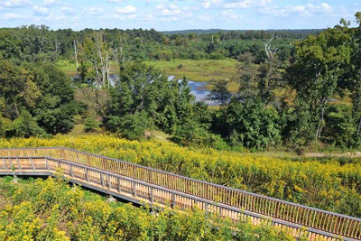
Discover Georgia's NPS Ocmulgee National Monument 1800's History and Culture.
History & Culture Chronology During the 1800s
1805 - The first Treaty of Washington cedes the remainder of the land between the Oconee and Ocmulgee Rivers, excluding a 3x5-mile strip known as the Old Ocmulgee Fields Reserve at present Macon, which the Muscogee (Creek) people refuse to give up.
The treaty allows the United states to construct a road across the Creek Nation to the Alabama River and facilities for public accomodations along this road. Much of this "Federal Road" follows the ancient Lower Creek Trading Path and eventually stretches from Washington, D.C. to New Orleans. The treaty also provides for a United States military fort on the Reserve to guard the frontier along the Ocmulgee River. This outpost is called Fort Hawkins in honor of Benjamin Hawkins, U.S. Indian Agent to the Creeks and friend of George Washington.
1806 - Fort Hawkins is built a short distance from the mounds. It serves as a frontier outpost, trading and center and location for treaty payments to the Creeks until the U.S. boundary is later extended to Alabama Territory. For the entirety of its existence as a U.S. military fort, it sat on land owned by the Muscogee (Creek) Confederacy.
1811 - Shawnee Chief Tecumseh, working with his brother the Prophet, travels up and down the frontier exhorting the Indians to discard their plows, whiskey and the white man’s ways. Some of the Creeks join his movement and nearly every town has a so-called "Red Stick" faction. The leaders are as divided as their people. William McIntosh emerges as leader of the faction loyal to the U.S. government. William Weatherford (Red Eagle) becomes the most important leader of the Red Sticks.
1812 - General Andrew Jackson (later President) stops at Fort Hawkins during the War of 1812. The fort is an important port of rendezvous for dispatching troops. This war with Great Britain concerns the issues of neutral maritime rights and British involvement in Indian problems along the frontier. Hostilities between Creek loyalists and traditionalist Red Sticks increases. Red Sticks attack and destroy Tuckabatchee and several other Upper Creek towns in northern Alabama.
1819 - The ancient Lower Creek Trading Path, now called the Federal Road, is the major artery from North to Southwest for many years (State Hwy 49 follows much of this route through Central GA). It serves as the postal route from New York to New Orleans. A ferry is built near the mounds on the Old Ocmulgee Fields Reserve, and the first white child, later Mrs. Isaac Winship, is born in the area.
1821 - The Creeks give up the lands between the Ocmulgee River and the Flint River.
1823 - The Creek Council passes a law providing the death penalty for anyone ceding land without the authority of the Council. Pressures for Indian removal continue to increase. Some Creeks, including William McIntosh, believe removal is inevitable. The City of Macon is laid out across the river from Fort Hawkins. The first newspaper in Middle Georgia, the Georgia Messenger, is published at Fort Hawkins, and a post office is established.
1825 - The Treaty of Indian Springs ceding the last Creek lands in Georgia is signed by Chief William McIntosh. His cousin is the governor of Georgia. He sells the Creek lands and is consequently assassinated by his own people. The treaty is declared illegal by the federal government, but Georgia authorities disagree. They press harder for removal.
1826 - The second Treaty of Washington officially surrenders the last Creek lands in Georgia. Some of the Creeks join the Seminole in Florida, others move into Alabama. About 1,300, mostly members of the McIntosh faction, resettle to the valley of the Arkansas River in "Indian Territory," now the state of Oklahoma, on lands given to them under the government’s voluntary removal program.
1828 - The Old Ocmulgee Fields Reserve, including Fort Hawkins and the mounds, is surveyed and laid off into land lots incorporated into the city of Macon. Roger and Eliazar McCall purchase a portion of the Old Fields and establish a successful flatboat manufacturing enterprise. Of the mound area, the local newspaper reported:
"The site is romantic in the extreme; that, with the burial mounds adjacent, have long been favorite haunts of our village beaux and belles, and objects of curiosity to strangers. We should regret to see these monuments of antiquity and of our history levelled by the sordid plow - - we could wish that they might always remain as present, sacred to solitude, to reflection and inspiration."
1836 - The Creek War of 1836 ends when about 2,500 people, including several hundred warriors in chains, are marched on foot to Montgomery, AL, and crowded onto barges during the extreme heat of July.
They are carried by steamboats down the Alabama River, beginning their forced removal to Indian Territory. During the summer and winter of 1836-early 1837, over 14,000 Creeks make the three-month journey to Oklahoma, a trip of over 800 land miles and another 400 by water. Most leave with only what they can carry.
1839 - The Cherokee begin their "Trail of Tears." A few escape and remain in the mountains of East Tennessee and North Carolina where most of their descendants now live on the Qualla Reserve around Cherokee, NC.
1843 - The Central Railroad constructs a railroad line into Macon through the Ocmulgee Old Fields destroying a portion of the Lesser Temple Mound and the great prehistoric town. A locomotive "roundhouse" is located near the Funeral Mound.
1840 - The huge oak trees on the mounds are cut for timber. Until this time, the Old Ocmulgee Fields and Brown’s Mount (another scenic prehistoric town about 6 miles down river) had been favorite resorts for picnics and parties, first by the officers at Fort Hawkins then by the residents of Macon. Much of the Macon Plateau site becomes part of the Dunlap Plantation. Clay for brick manufacturing is mined near the Great Temple Mound and a fertilizer factor is constructed nearby.
1864 - Union General George Stoneman nears the city of Macon in July. Governor Brown, who is in Macon, calls for every able-bodied Man to defend the city. A battery is stationed near the site of Fort Hawkins. Big guns are loaded on flatcars at the railroad bridge over the Ocmulgee River inside the boundary of what is now the Ocmulgee National Monument.
Gen. Stoneman destroys Griswoldville, continues to Macon and burns the railroad bridge over Walnut Creek on the Dunlap property. He uses the Dunlap's farm house as his headquarters during the ensuing battle. Failing to take the city, Stoneman and his troops are pursued into nearby Jones County, where they are defeated at Sunshine Church. Gen. Stoneman and his officers are incarcerated at Camp Oglethorpe in Macon and his enlisted men are sent to the infamous prisoner of war camp at Andersonville. Stoneman is the highest ranking Union officer taken prisoner during the Civil War.
1874 - A second huge cut for a railroad (still in use) is excavated through the mound area and destroys a large portion of the Funeral Mound. According to Charles C. Jones, in his book, Antiquities of the Southern Indians, many relics and human burials are removed during this work.


 The treaty allows the United states to construct a road across the Creek Nation to the Alabama River and facilities for public accomodations along this road. Much of this "Federal Road" follows the ancient Lower Creek Trading Path and eventually stretches from Washington, D.C. to New Orleans. The treaty also provides for a United States military fort on the Reserve to guard the frontier along the Ocmulgee River. This outpost is called Fort Hawkins in honor of Benjamin Hawkins, U.S. Indian Agent to the Creeks and friend of George Washington.

 Gen. Stoneman destroys Griswoldville, continues to Macon and burns the railroad bridge over Walnut Creek on the Dunlap property. He uses the Dunlap's farm house as his headquarters during the ensuing battle. Failing to take the city, Stoneman and his troops are pursued into nearby Jones County, where they are defeated at Sunshine Church. Gen. Stoneman and his officers are incarcerated at Camp Oglethorpe in Macon and his enlisted men are sent to the infamous prisoner of war camp at Andersonville. Stoneman is the highest ranking Union officer taken prisoner during the Civil War.