Explore the Ocmulgee National Monument 'Fall Line'.
Ocmulgee National Monument 'Fall Line' History
Eons ago, ocean waves pounded the southeastern shoreline of the North American continent. The warm sea deposited sand, silt and marine clays along the beach. Gradually, the sea retreated and reveled a sandy plain. This former beach with its dunes, remained as a narrow band separating the Coastal Plain from the rolling, rocky hills of the Piedmont to the North.
The environmental variations within this region afford diverse natural resources and habitat for a rich variety of plants and wildlife, including a number of endangered and threatened species. The park's 702 acres encompass upland fields and forests, with riverine woods and wetlands along Walnut Creek and the river.
The Ocmulgee River Heritage Greenway provides an undeveloped corridor between Ocmulgee National Monument and Bond Swamp National Wildlife Refuge downriver.
Our new board walk, which crosses 800 feet of emergent wetlands, allows a view into the heart of this exciting new ecosystem with a diverse selection of birds, plants, animals and reptiles.
'Fall Line' Environment
5 miles of trails, including the Opelofa, Loop, Bartram, McDougal, and Mound Village Trails, connect the major features of the park. During the Early Mississippian Period (AD 900-1150), a thriving culture flourished here on the Macon Plateau. These true farmers planted crops in extensive fields and lived in large villages with intricate social relationships as suggested by their earthlodges and huge flat-topped mounds.
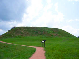
A 2-mile road allows easy access to several earthen mounds including the Great Temple Mound, the largest of the 7 mounds rising 50 feet from the base, and the Funeral Mound which was the burial place for the leaders of this complex society.
Ocmulgee National Monument and present-day Macon are located at the Fall Line, where 2 great environmental zones (Piedmont and Coastal Plain) overlap. Upstream from Macon, the Ocmulgee River flows between rolling hills, its channel marked by stretches of rocky shoals and rapids. Below Macon, the river changes character. Its waters move languidly through wide floodplains filled with wooded wetlands, swamps and oxbow lakes where Bald Eagles now thrive for the first time since the 1930's. Much of this area is now protected within Bond Swamp National Wildlife Refuge.
Ocmulgee National Monument's 702 acres encompass forested uplands, open fields, year-round wetlands, and thickly wooded river floodplain. A relatively undeveloped greenway extends along the river between Ocmulgee National Monument and Bond Swamp National Wildlife Refuge about 5 miles downstream. Because of its Fall Line location, numerous habitats, and connections to a larger ecosystem, Ocmulgee is home to a wide variety of plant and wildlife species, and is visited seasonally by many migrant birds, including endangered Woodstorks.
Wildlife - Amphibians
The species listed below are likely to occur within or near the vicinity of the park. However, the park itself may or may not support viable populations of all species due to localized distribution patterns or to lack of appropriate habitat within the park boundaries.


 Eons ago, ocean waves pounded the southeastern shoreline of the North American continent. The warm sea deposited sand, silt and marine clays along the beach. Gradually, the sea retreated and reveled a sandy plain. This former beach with its dunes, remained as a narrow band separating the Coastal Plain from the rolling, rocky hills of the Piedmont to the North.
 A 2-mile road allows easy access to several earthen mounds including the Great Temple Mound, the largest of the 7 mounds rising 50 feet from the base, and the Funeral Mound which was the burial place for the leaders of this complex society.
 Turtles