Welcome to www.n-georgia.com Georgia's NPS Ocmulgee National Monument History & Culture 1900's to Present - From ice age to space age,
it is a memorial to the relationship of people and natural resources in this corner of N America. We preserved a continuous record of human life in the SE from the earliest times to the present. Its more than 12,000 years of human diversity of natural and cultural resources combined that provides an abundance of reasons to visit.
Free Stuff To Do In Georgia Georgia Overnight Accommodations Shopping in Georgia Videos of places and things to do in Georgia Georgia Department of Labor Weather in Georgia Maps of places in Georgia Contact Us Advertise in N-Georgia.com

N-Georgia.com Website

Georgia's 9 Travel Regions

ADA Access Locations
Georgia Monthly Festivals and Events
Georgia Festivals and Events
Georgia State Parks
Georgia County Parks
Georgia Wildlife Resources Division Areas
Georgia WRD Archery and Firearms Ranges
Georgia U. S. Forests
Georgia National Parks Services
National Parks Services Augusta GA Historic Sites
NPS Georgia Coast and Islands Historic Sites
Georgia Horseback Riding Trails
Georgia Mountain Bike Trails
Georgia Off Highway Vehicle Trails
Georgia Driving Tours
Georgia Covered Bridges
Georgia Waterfalls
Georgia Lakes
Georgia Fishing Lakes
Georgia Rivers
Georgia Coast and Islands
Georgia Planetariums and Observatories
Georgia Audubon Society
Georgia Farmers Markets
Georgia Gardens
Georgia Historic Sites
Georgia Civil War Sites
Georgia Museums
Miscellaneous Fun Activities
Outdoor Safety Tips
Georgia Tourist Centers
Georgia Visitor Centers
Ocmulgee National Monument
History & Culture Chronology During 1900 to Present
Bullet1933 - A large portion of McDougal Mound is removed to use as fill dirt for Main Street. Motorcycle hill-climbing leaves scars on the slopes and summit of the Great Temple Mound. A group of local citizens are convinced that the mounds are of great historical significance and should be preserved. Led by General Walter A.Harris, Dr. Charles C. Harrold, and Linton Solomon, they seek assistance from the Smithsonian Institution, which sends Dr. Arthur Kelly to organize and conduct archeological excavations on the Macon Plateau.
Bullet1934 - Archeological treasures are unearthed. As the work progresses, a bill is passed by Congress to authorize establishment of a 2,000-acre Ocmulgee National Park. The archeological effort is largest excavation ever, until this time, undertaken in the country. Labor is provided by hundreds of workers employed under several Great Depression-era public works programs.
Bullet
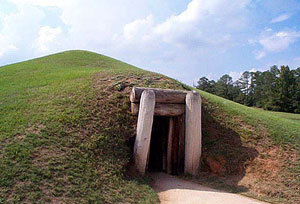
1936 - President Franklin D. Roosevelt on December 12th signs the Proclamation establishing Ocmulgee National Monument and directing the National Park Service to preserve and protect 2,000 acres of "lands commonly known as the Old Ocmulgee Fields..." Due to economic constraints, only 678.48 are acquired, including 40 acres at the detached Lamar Mounds and Village. Later, an additional 5 acres are added to the Lamar Mounds and Village Unit and the parcel known as Drakes Field is donated to the nation for inclusion in Ocmulgee National Monument by the City of Macon. The park presently encompasses 702 acres.
Bullet1940 - Great Depression Relief-era crewmen, including members of Civilian Conservation Corps Company 1426 stationed at Ocmulgee National Monument, are drafted into military service as the United States enters World War II. Man are sent to nearby Camp Wheeler which becomes the largest infantry training camp in the nation.
Bullet1960's - An interstate highway (I-16), constructed through the Macon Plateau Unit, cuts the primary visitor use area off from the park's mile-long river boundary and causes significant hydrological changes to lands located in the river floodplain. During archeological excavation within the highway corridor inside the park, evidence of Muscogee (Creek) and earlier settlement, along with three human burials, are discovered. A number of important prehistoric and historic sites outside the park are destroyed or heavily damaged, including the nearby Gledhill I, II and III (where an Ice Age Clovis spearpoint is found by an artifact collector during removal of fill dirt for road construction), along with the New Pond site, Adkins mound, and Shellrock Cave. Archaic, Woodland, Mississippian and historic Creek villages and campsites across the river, such as Mile Track, Napier, Mossy Oak and Horseshoe Bend, are already damaged by levee construction in the 1940's.
Bullet1970's - The Swift Creek Mounds and Village, type-site for a widespread Woodland Period culture, is destroyed for construction of a Bibb County Sheriff's Department firing range. Dr. Kelly's early archeological collections, still under the care of the National Park Service, are all that remain of this large site, which was located on the Ocmulgee Old Fields near the Lamar Village Unit of Ocmulgee National Monument.
Bullet1992 - Descendants of Roger and Eliazar McCall donate almost 300 acres, adjoining the park's Walnut Creek boundary, to the National Park Service. The Archeological Conservancy accepts ownership pending legislation to incorporate it into Ocmulgee National Monument. The land, owned by this family for almost 175 years, has been designated the Scott-McCall Archeological Preserve.
Bullet
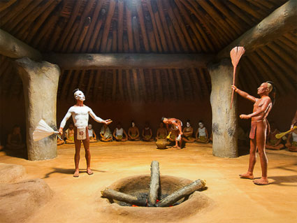
1997 - The Old Ocmulgee Fields are determined eligible to become the first National Register of Historic Places listing for a Traditional Cultural Property, or District, east of the Mississippi River. This distinction recognizes the area's great significance to the Muscogee (Creek) people.
BulletPresent - The park's staff, the OcmulgeeNational Monument Association, the Friends of Ocmulgee Old Fields, and the park's many volunteers remain dedicated to the mission of protecting and preserving this very special place for the enjoyment of today's citizens and future generations.
Bibliography for Ocmulgee Historic & Cultural Info
Corkran, David H. The Creek Frontier, 1540-1783.
Norman: University of Oklahoma, Press, 1967.
Cotterill, Robert S. The Southern Indians, The Story of the Five Civilized Tribes Before Removal.
Norman: University of Oklahoma Press, 1954.
Debo, Angie. The Road to Disappearance: A History of the Creek Indians. Norman: University of Oklahoma Press, 1941.
Eggleston, George Cary. Red Eagle and the Wars With the Creek Indians of Alabama. New York: Dodd, Mead, 1878.
Foreman, Grant. The Five Civilized Tribes. Norman: University of Oklahoma Press, 1934.
Foreman, Grant. Indian Removal. Norman: University of Oklahoma Press, 1932.
Foreman, Grant. Indians and Pioneers. Norman: University of Oklahoma Press, 1932.
Green, Donald. The Creek People. Indian Tribal Series. Phoenix, 1973.
Griffith, Benjamin W., Jr. McIntosh and Weatherford, Creek Indian Leaders. University of Alabama Press. 1988.
Hudson, Charles M. The Southeastern Indians. Knoxville: The University of Tennessee Press, 1976.
Swanton, John R. Early History of the Creek Indians and Their Neighbors.
Bureau of American Ethnology, 73rd Bulletin, Washington, D.C., U. S. Gov't Printing Office, 1922.
White, George. Historical Collections of Georgia. New York: Rodney & Russell, 1854

Disclaimer Accessibility Privacy Policy FOIA Notices USA.gov
Phone & Address
478-752-8257 - Location: Ocmulgee National Monument, 1207 Emery Hwy, Macon, GA 31217
Operating Hours, Seasons & Phone Contact
BulletOpen daily, 9 am. to 5 pm.
BulletClosed Christmas (Dec 25) and New Years Day (Jan 1)
BulletSpring - Cool nights and warm days bring unpredictable rains and a forest filled with flowers.
BulletSummer - Very hot and humid days, with lots of insects to keep you company. Bring a good hat and a water bottle to go walking.
BulletAutumn - Lush green fields blossom with a variety of fall colors. Birds heading south stop to visit our wetlands areas. A great season to visit.
BulletWinter - Sunshine warms the cold mornings providing perfect weather for a family hike. Not a mosquito to be seen! Great time of year to come for a walk in the park.
Fees & Reservations
Except for special events sponsored by the Ocmulgee National Monument Association no fees are charged to enter and visit Ocmulgee National Monument. During the special events of the Ocmulgee Indian Celebration (third weekend in September) and the spring Lantern light Tours (March) an event fee of $5 is charged for anyone 13 years and older.

Special Use Permits are available through a permitting process. The application fee for a special use permit is $50. Other charges may apply depending on the needs of the group applying for a special use permit.
Directions to Ocmulgee National Monument
Drive south on I-75 to Macon. Exit I-75 onto I-16 east (exit on left) . Get off I-16 at exit 2 (Coliseum Drive), take a left under the highway and proceed to where Coliseum Dr. ends at Emery Highway. Turn right on Emery Highway and proceed to the third light. Our entrance is on the right side of the road.
Interesting Ocmulgee National Monument Facts
Ocmulgee National Monument preserves and displays a collection of archeological artifacts dating back more than 12,000 years. From early Clovis points through colonial bells and a 300 year old sword, the collection demonstrates our historic connection to all cultures from Stone Age to Space Age.
An 800 foot boardwalk lets you visit the emergent wetlands at Ocmulgee National Monument. This 10 year old wetlands was created as a result of a massive flood in July 1994. The changes in the landscape from hardwood forest to emergent wetlands is an example of natures cycles.
Designs like this person in a canoe show us art and views of life from the ancient past. Carved into a seashell, we wonder today if jewelry like this was just ornimentation or if perhaps each design had important symbolic meanings.
During the archeological investigations at Ocmulgee National Monument during the 1930's, Dr. Arthur Kelly and his crew of more than 800 CCC workers discovered this well preserved example of a Southeastern native Mississippian Council Chamber.
The Dunlap House is 150 years old and was built here at Ocmulgee National Monument when the land was used as a dairy farm. It is listed on the National Register of Historic Places.
Intricate and complex designs carved into sea shells were one of the many art forms of the Native people of middle Georgia 1000 years ago. Meanings and symbolism of images such as this spider reach out to us through time from these ancient artists and crafts people.
Red wild flowers
Custom Search

Ocmulgee Monument History & Culture:

BulletPre-9000 BC - 1700's
Bullet1800's
Bullet1900's to Present
BulletNature & Science
BulletField Trip Activities for Teachers & Students


HomeFree Stuff To Do - Festivals & Events - Monthly Events - State Parks - County Parks  - Georgia National ForestsWildlife Areas    
WRD Archery & Firearms Ranges - National Parks Services Sites - Horseback Riding Trails - OHV Trails - Bike Trails - Driving Tours
Covered Bridges - Civil War Sites - Historic Sites - Augusta NPS - Coastal NPS - Museums - Coast & Islands - Rivers - Lakes - Fishing Lakes - Waterfalls - Gardens - Planetariums - Audubon Society - Farmer Markets - Misc. Fun - ADA Access - Travel Regions - Tourist Centers
Visitor Centers - Maps - Videos - Safety Tips  - Lodging - Shopping - Dept of Labor - Weather - Advertising  - Privacy Policy -  Contact

Website created and Copyright ©2010 by Sandy's Grafix. All rights are reserved. Website updated on 1/24/2010