|
|
Enjoy picnicking, campgrounds, boat launch ramps, swimming areas, group picnic shelters, playgrounds and hiking trails at Lake Lanier parks.
Some are pet friendly. The Army Corps of Engineers, Forsyth County, City of Cumming, City of Gainesville and Lake Lanier Islands operate these parks around the lake.
Contact Numbers: Water Release Schedules 770-945-1466 - Lake Info 770-945-1467. For more information, call contact number listed with each park.
Make reservations at 877-444-6777 to stay at the Army Corps of Engineers parks.
Directions to Lake Lanier Visitor Center: From I-985/Buford Take GA Hwy 20 West, from GA 400/Cumming, take GA Hwy 20 East, to North on Suwanee Dam Road. Go 3 miles and go left on Buford Dam Road. The Visitor Center is one mile down on the right.
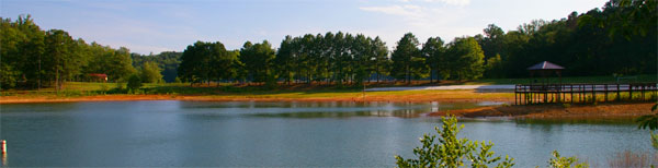
Georgia's Beautiful Lake Sidney Lanier - Located in the foothills of the Blue Ridge Mountains in North Georgia is Lake Lanier, one of the most popular lakes in the SE. Lake Lanier is a large reservoir formed from the Chattahoochee River. Buford Dam is at the south end of the lake. |
| Lake Lanier Day Use Parks and Amenities |
| Balus Creek Park - Amenities: Restrooms ane boat ramps. Has a user fee. Pets are allowed. Open all year. Phone: Army Corps of Engineers at 770-945-9531 - Address: Balus Creek Drive in Flowery Branch, Georgia - Directions: Take exit 16 (Mundy Mill),off of I985, west towards Lake Lanier and then take a right on McEver and then a left on Mountain View Road to the park. |
| Bethel Park - Amenities: Restrooms, boat ramp, dock and pets allowed. Address: Bethel Road, Gainesville Georgia - Directions: Take exit 17 (Hwy 306),off of GA 400, east and then take a right on Hwy 369 (Browns Bridge Road); take a right onto Bethel Road and follow to the park entrance. |
|
| Big Creek Park - Amenities: Restrooms, boat launch ramp, sandy beach, user fee and pets allowed. Owned by Lake Lanier Islands. Phone: Lake Lanier Islands at 770-945-8787 - Address: Holiday Road in Buford, Georgia. Directions: Located at the end of Big Creek Road, off Holiday Road in Buford. Next to Big Creek Tavern and near the marinas on Holiday Road. |
| Bolding Mill Day Use Park - Amenities: Restrooms, picnic tables, picnic shelter, boat ramp, swim area and playground. Pets are allowed. Has free life jacket loaner program. Park and boat ramp open all year. Phone: Army Corps of Engineers at 770-945-9531 - Directions: From Atlanta, take SR 400 north to Exit 17, turn right on GA Hwy 306, turn right on GA Hwy 53, turn left on Old Sardis Rd, and turn left on Chestatee Rd. Follow into park and campground. |
| Buford Dam Park - Amenities: Laundry, picnic tables, picnic shelter, boat launch ramp, beach with swim area, volley ball and basketball areas, playgrounds and user fee. Note: No pets allowed. Laurel Ridge Trail (3.8 miles) goes through Buford Dam Park, Powerhouse Park and Lower Overlook. Has free life jacket loaner program. Open April 1 through third week in September. It is a fee park with cost per vehicle and for pedestrians. Shelters in Buford Dam Park can be rented. Call to make reservations. Phone: Army Corps of Engineers at 770-945-9531 - Address: 1200 Buford Dam Rd., Cumming, Georgia - Directions: Take exit 14 (Hwy 20),off of GA 400, east and then take a left on Market Place Blvd., take a right on Buford Damn Road and the park will be on your left after you pass over the damn. |
| Burton Mill Park - Amenities: Restrooms, boat ramp, beach, swim area, walking trail that goes through woods, user fee. NO pets are allowed. Has free life jacket loaner program. Open: Ramp all year and park is open April 1 though third week in September. Phone: Army Corps of Engineers at 770-945-9531 - Location: Yacht Club Road off Gaines Ferry Rd, Flowery Branch GA |
| Charleston Park - Amenities: Restrooms, picnic tables, grills, boat ramp, user fee. Pets are allowed. Fee to launch your boat. Phone: Forsyth County Parks and Recreaton at 770-781-2215 Address: 6020 Browns Bridge Road (GA 369), Gainesville, Georgia - Directions: From GA 400 take exit 17 and go east towards Lake Lanier; take a right on on Hwy 369 (Browns Bridge Road) and then a right on Charleston Park Road to the park. |
|
| Clarks Bridge Park - Amenities: Boat launch ramp, dock, picnic tables, grills, swimming platform, beach, designated swim area, bathrooms, boat launch ramp, boat dock, canoe and kayak club, rowing club (row the 1996 Olympic course), canoe and kayak rentals, and Lanier Centre. Phone: Hall County Parks and Recreation at 770-535-8280 - Address: 3105 Clarks Bridge Road, (off Limestone Rd.) Gainesville, GA - Directions: From I-985, take exit 24, go left at end of ramp, go 1/2 mile, take right onto Limestone Parkway, go 2 miles, take right onto Clarks Bridge Road, go 2 miles, cross Clarks Bridge, the park is on both sides of the road. |
| Duckett Mill Park - Amenities: Boat launch ramp, playground and swimming area. Pets are allowed. Has free life jacket loaner program. Open all year. Phone: Army Corps of Engineers 770-945-9531 - Address: Duckett Mill Rd, Oakwood (off Dawsonville Hwy/GA 53), GA |
|
| East Bank Park - Amenities: Restrooms, picnic tables, boat launch ramp, docks, user fee. Pets are allowed. Open all year. Phone: Army Corps of Engineers 770-945-9531 - Located off Buford Dam Rd in Buford - close to the Dam Store. Directions: Take exit 14 (Hwy 20),off of GA 400, east and then take a left on Market Place Blvd., take a right on Buford Dam Road and the park will be on your left after you pass over the dam. |
| Holly Park - Amenities: A small boat ramp and two areas with beautiful locations overlooking the lake and a large, sandy swimming beach. Phone: City of Gainesville at 770-531-2680 - Address: 2603 Old Thompson Bridge Road, NW, Gainesville, GA 30501 - Directions:From South - I-985, take exit 22, go left at end of ramp, following US Highway 129 North for about 2 ½ miles (Highway 129 will become Historic Green Street). When you come to the split of Highway 129 & Highway 60, follow Highway 60. Travel on Highway 60 (Thompson Bridge Road) for approximately 1½ miles. Turn left onto Old Thompson Bridge Road (Edgewater Apartments) turn left and follow to entrance of park. |
Visit more Lake Lanier Parks Below:
Keith's Bridge, Lanier Park, Lanier Point Park and Athletic Complex, Laurel, Little Hall, Little Ridge, Little River, Long Hollow, and Longwood Park - Rock Creek Greenway- Click here for these parks.
Lower Overlook, Lower Pool East, Lula, Mary Alice, Mountain View, Nix Bridge, Old Federal, Powerhouse, Robinson and Sardis Creek - Click here for these parks.
Shoal Creek Day Use, Simpson, Six Mile Creek, Thompson Bridge, Thompson Creek, Tidwell, Toto Creek, Two Mile Creek, Van Pugh North, Vann's Tavern, Wahoo Creek, War Hill, West Bank and Young Deer Creek - Click here for these parks. |
|
| |
|

Check These Out:
 Lake Lanier Parks Lake Lanier Parks
Lake Lanier Campground
Lake Lanier Regulations
Lake Lanier Fishing Info

Georgia Lakes
WMA Public Fishing Areas
GA Fishing Lakes
Georgia Rivers & Map
GA Lakes & Rivers Map
Water Safety
|