|
| Lake Conasauga Overflow Campground - General Information |
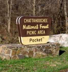
This lovely recreation area in Northwest Georgia is named for lying in a low area surrounded by the majestic steep ridges of Horn and Mill Mountains. It is the former site of Civilian Conservation Corp Camp F-16.
 There are 26 campgrounds here. Each site has a parking spur, tent pad, fire ring & picnic table. There are no showers or electricity. Most of the campsites are along the creek. Families camping here can enjoy the vibrant spring colors of mountain laurel as well as the brilliant fall color mix provided by mixed hardwoods. There are 26 campgrounds here. Each site has a parking spur, tent pad, fire ring & picnic table. There are no showers or electricity. Most of the campsites are along the creek. Families camping here can enjoy the vibrant spring colors of mountain laurel as well as the brilliant fall color mix provided by mixed hardwoods.
Located back in the woods and along a spring-fed creek, this area offers camping, picnicking and hiking. Visitors who wish to picnic have 17 picnic tables to choose from. A large picnic shelter that will accommodate up to 80 people may be reserved.
Hikers can enjoy the 2.5-mile Pocket Loop Trail, which originates at the camp area, or the 0.5-mile Pocket Nature Trail, which originates at the parking area. The loop through recreation area is gravel. Picnic shelter and one camping spur are wheelchair accessible. The 27 campsites have tent pads, picnic tables and grills.
Reservations Reservations are not required. Campsites are on a first come, first serve basis.
Fees: $10 per site per night.
Open: April through October 24 hours. Quiet hours are 10 pm to 6 am. Call for specific open dates. Closed rest of year. |
|
Restrictions: Campsites are for 1 family or 5 adults. Site must be occupied first night of stay. Maximum two vehicles per campsite. 14-day limit. Dogs must be leashed at all times.
Closest Town: The nearest town is Dalton, GA. It is approximately 25 miles east. Campers will find numerous restaurants, grocery stores and gas stations available.
Water: Drinking water available at hydrants located throughout the campground.
Restroom Facilities: Flush Toilets
More Recreation Activities
Day Hiking - The 2.5 mile Pocket Trail is for foot travel only. It begins in the picnic area and end in the campground. The trail passes areas with seeps and springs. Take a liesurely walk and enjoy the landscape and forest of the Ridge and Valley area of northwest Georgia. The difficulty level is easy.
Recreation Activities Nearby: The Johns Mountain Overlook and trail are located nearby, as well as Keown Falls Scenic Area and Keown Falls Recreation Area. Calhoun and Villa are interesting towns to visit.
River and Stream Fishing - See GA DNR fishing regulations and information. |
|
| Contact, Directions & GPS Location |
USDA Forest Service, Conasauga Ranger District office - Phone: 706-695-6736 Address: 3941 Highway 76, Chatsworth, GA 30705
Chattahoochee-Oconee National Forests - Phone: 770 297-3000
Address: 1755 Cleveland Highway, Gainesville, GA 30501
Office hours: Tuesday - Friday at 9 - 12 & 1-4 - Closed Saturday, Sunday, and Monday
Directions: Take U.S. 411 north from Chatsworth for 4 miles; turn right (east) at traffic light in Eton; Follow Forest Service Road 18 east for 10 miles; turn left (northeast) on Forest Service Road 68 for 10 miles.
The Pocket Campground GPS Location - Latitude is 34.584750 and Longitude is -85.085300. |
|
| |
|

Gerogia US Forest Areas
 Camping Hiking Camping Hiking
Horseback Riding Trails
FishingCanoe Trails
GA US Forest Wilderness
Wilderness Preparation
Canoe Safety Tips
Forest Safety Tips
GA U S Forest History

|