|
| Pinhoti Trail General Information |
It also serves as an excellent connector trail, linking the Pinhoti Trail in Alabama to the Appalchian Trail atop Springer Mountain, via the Benton MacKaye Trail found on the South Fork of Jacks River within the Conasauga Ranger District. There is no charge to use this popular trail.
Restrictions: Motorized traffic: is not allowed on the Pinhoti Trail with the exception of those segments where the trail follows public roads. Non-motorized mountain bikes: allowed on all sections except the Bear Creek Loop to the Mountaintown Creek Trail. Horses: allowed on all sections except the Hurricane Trail junction to Dug Gap, and from Tatum Lead Road to Forest Road 64 at Buddy Cove Gap. Horse and bike traffic must use the northern route around Keown Falls and Pilcher Pond.
Parking: The Conasauga Forest Ranger District manages multiple Trailheads along the Pinhoti Trail. The parking areas vary in size.
Large parking areas accommodating many cars and horse trailers are:
Snake Creek Gap (Georgia Highway 136)
HighPoint trailhead (Georgia Highway 100)
Trailheads with smaller parking areas holding anywhere from 3-5 cars but only 1-2 horse trailers at most:
Old Narrows Picnic Area
West Armuchee Creek (Manning Mill Road)
Hurricane Creek
Jacks River Fields Campground and Horse Camp
Other smaller parking (holding 2-6 cars but not appropriate for horse trailers) are:
East Armuchee Road
Johns Mountain Overlook
Keown Falls Recreation Area
Pilcher Pond parking area on Pocket Road
Bear Creek
Mack White Gap (U.S. Highway 27)
Directions: See the Pinhoti Trail website at http://www.georgiapinhoti.org/joomla/ for directions, events and more info.
Closest Towns: Stores can be found along road-walk sections of the trail between Cave Spring and Coosa, and between Dalton and Chatsworth. A wide range of services, including medical services, are available in Rome, Summerville, Dalton, and Chatsworth. |
|
| More Outdoor Recreational Activities on Pinhoti Trail |
Dispersed Camping is allowed on any Forest Service lands along the trail unless there is a specific posted prohibition. Be aware that the trail passes through private property, where camping is prohibited. Safety Information: Long sections of the trail are along ridgelines where there is no water. When water sources are encountered, consider the water to need boiling or chemical treatment before it is safe for human consumption (many larger streams are downstream from livestock and agricultural enterprises). Water sources that are available in winter may be dry in summer and fall.
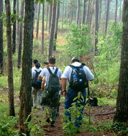
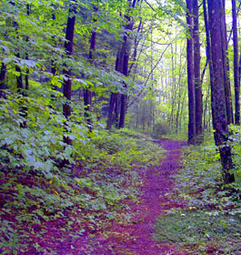
Day Hiking - You don't have to be a backpacker to enjoy this amazing trail. According to one of our very own seasoned hiking professionals here on the Forest, there are numerous wonderful day hiking opportunities on the Pinhoti. One such opportunity awaits visitors at the Cohutta Overlook. Here one can hike in as far as one chooses, and enjoy stunning vistas (especially in the winter!), passing through gaps and over creeks. The return trip, although along the same path, promises different views of the scenery along the trail.
To start your hike, follow Highway 52 west from the Cohutta Overlook parking area about 100 feet to the trailhead. The trail is marked with either a plastic “turkey foot” blazer or a white paint blaze.
Horse Riding - What a treat it is to go horseback riding on a trail like the Pinhoti! Please see Restrictions above for the areas where horsback riding is not permitted on the Pinhoti. For more information on joining a group ride, horseback riding organizations in Georgia or equestrian conservation awareness, please visit any of the websites, http://www.ride-ctha.org/ |
| Contact Info |
USDA Forest Service, Conasauga Ranger District office - Phone: 706-695-6736 Address: 3941 Highway 76, Chatsworth, GA 30705
Chattahoochee-Oconee National Forests - Phone: 770 297-3000
Address: 1755 Cleveland Highway, Gainesville Georgia 30501
Office hours: Tuesday - Friday at 9 - 12 & 1-4 - Closed Saturday, Sunday, and Monday |
| The Conasauga Ranger District covers the western third of the Chattahoochee National Forest. A diverse set of landscapes make up the Conasauga district, from the ridges and valleys west of Interstate 75 to the Cohutta Mountains northeast of Chatsworh, GA. This part of the forest offers some of the best scenery and outdoor recreational activities in north Georgia. |
|
| |
|
Georgia US Forest Areas
 Camping Hiking Camping Hiking
Horseback Riding Trails
FishingCanoe Trails
GA US Forest Wilderness
Wilderness Preparation
Canoe Safety Tips
Forest Safety Tips
GA U S Forest History

|