Discover Darien Georgia Fishing Communities and Boat Ramps - Darien offers many great locations to fish with or without a boat. Stay and Play in GA!
Non-Boating Fishing Docks Sites
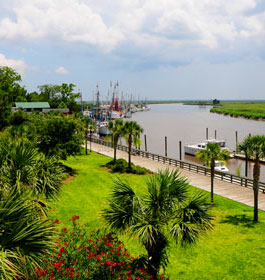
Darien Georgia Waterfront Dock: From I 95, take Exit 49 south on GA Hwy 251 for 1.2 miles to U.S. Hwy 17. Turn right (south) 1.2 miles to Broad Street. Turn left before crossing Darien River Bridge. Immediately after left turn, waterfront dock located on right behind Welcome Center. Also see Darien's newly restored DDA Waterfront Dock which is handicapped accessible.
Butler River Bridge: From Interstate 95, take Exit 49 south on GA Hwy 251 for 1.2 miles to U.S. Hwy 17. Turn right (south) 2 miles to the Butler River Bridge. Parking area on the right. Handicapped accessible.
Champney River Bridge Catwalk: From I 95, take Exit 49 south on GA Hwy 251 for 1.2 miles to U.S. Hwy 17. Turn right (south) 3.3 miles to the Champney River Bridge. Parking area on left past bridge. Handicapped accessible.
Blue-N-Hall Fishing Dock: From Interstate 95, take Exit 49 south on GA HWY 251 for 1.2 miles to U.S. Hwy 17. Turn right (south) 0.9 miles to GA Hwy 99. Turn left (north) 4.4 miles to Blue-N-Hall sign. Turn right and follow dead end road to boat dock.
Harris Neck Wildlife Refuge Fishing Dock: Take Exit 12 south on U.S. Hwy 17 for 1.0 miles to GA Hwy 131. Turn left (south) 6.2 miles to Harris Neck Creek Bridge near entrance to Harris Neck Wildlife Refuge. Dock located on left.
Shellman Bluff Fishing Dock: Take Exit 11 south on GA Hwy 57 for 1.0 miles to U.S. Hwy 17. Turn left (north) 2.2 miles to Pine Harbor Road. Turn right 0.1 miles and then turn left on Shellman Bluff Road and drive 6.8 miles. At stop sign, turn right toward Southerland Bluff then immediately take first road on left 0.2 miles to Broro River Bluff. Turn left 0.1 miles to dock. Must have permission to fish off dock. Phone (912) 832-5426.
Darien Georgia City Boat Ramp (west of the bridge): This is a public boat ramp and docks. There are 6 parking spaces for vehicles pulling trailers. There is also a strict, 6-hour tie-up limit; long term mooring is not permitted.
The Waterfront Park Docks (east of the bridge): These docks offer long-term mooring for a fee. Contact the McIntosh County Development Authority at 912-437-6659 or 912-437-8777 or FAX to: 912-437-3505. Directions: From I 95, take Exit 49 south on GA Hwy 251 for 1.2 miles to U.S. Hwy 17. Turn right (south) 1.2 miles to Broad Street. Turn right before crossing Darien River Bridge Drive approximately 0.1 miles and take first left. Boat ramp located at bottom of bluff. (One single-lane ramp).
Champney River Boat Ramp: This is double-lane public boat ramp on deep water with portalets, potable water, and parking for up to 50 vehicles pulling trailers. The Department of Natural Resources maintains an oyster shell collection/recycling area at the south end of the park. Directions: From I 95, take Exit 49 south on GA Hwy 251 for 1.2 miles to U.S. Hwy 17. Turn right (south), go 3.3 miles and cross the Champney River Bridge. Turn left into parking area at south end of bridge.
Two Way Fish Camp Boat Ramp: Offers sling launch and retrieve which many people prefer to save their trailers from rusting. Not a public ramp; fees apply. Directions: From I 95, take Exit 49 south on GA Hwy 251 for 1.2 miles to U.S. Hwy 17. Turn right (south) , go 3.3 miles and cross the Champney River Bridge. Continue south a short distance, cross the Altamaha River Bridge and turn left at the sign for the "Two Way Fish Camp."
Barbour River Landing: One single-lane ramp. Directions: Take Exit 12 south on U.S. Hwy 17 for 1.0 miles to GA Hwy 131. Turn left (south) 7.1 miles to end of Harris Neck Road (Hwy 131). Turn left into Harris Neck Wildlife Refuge on Barbour Landing Road and drive 0.5 miles to boat ramp. Boat ramp located on right. This facility is closed during Wood Stork nesting and feeding season (Open March 1 - August 31).
Bellville Boat Ramp: One single-lane ramp. Directions: Take Exit 11 south on GA Hwy 57 for 5.1 miles to Bellville Road. Turn left 1.6 miles to boat ramp. (One single-lane ramp.)
Blue-N-Hall Boat Ramp: Directions - Take Exit 10 south on GA Hwy 251 for 1.2 miles to U.S. Hwy 17. Turn right (south) 0.9 miles to GA Hwy 99. Turn left (north) 4.4 miles to Blue-N-Hall Park sign on right. Turn right and follow dead end road to boat ramp.
Harris Neck Wildlife Refuge Boat Ramp: Recommended for small boat launching only. (One single-lane ramp). Directions: Take Exit 12 south on U.S. HWY 17 for 1.0 miles to GA Hwy 131. Turn left (south) 6.2 miles to Harris Neck Creek Bridge located at Harris Neck Wildlife Refuge. Boat ramp located on left after crossing bridge.
White Chimney Creek Boat Ramp: One single-lane ramp. Directions: Take Exit 11 south on GA Hwy 57 for 1.0 miles to U.S. Hwy 17. Turn left (north) 2.2 miles to Pine Harbor Road. Turn right 0.1 miles and then turn left on Shellman Bluff Road for 4.5 miles to ramp located on right across White Chimney Creek Bridge.
More Info
More info and pictures. Bait, Tackle and Fishing Licenses - First GA Hardware & Marine
Broad St, Darien Georgia 31305
- Phone: 912-4374366