|
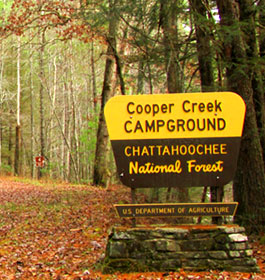
| Cooper Creek Recreation Area - Campground and General Information |
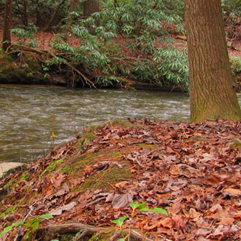
This campground is located along the banks of Cooper Creek in the North GA mountains. Fun activites, including camping, hiking, trout fishing, and hunting. Anglers may fish Cooper Creek and nearby Mulky Creek seasonal trout streams for wild and stocked trout. |
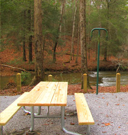
 Campground Amenities - 15 camping sites. Four of the sites are waterfront. There are no water or electric hook-ups or dump station available in the campground. All of the sites are within easy walking distance of the creek. Each campsite has standard amenities: a tent pad, picnic table, lantern pole, and grill. Good, hard surface roads until you reach Forest Service Road 4; this road is a gravel road and is crooked and steep in parts. Restrooms have railings to assist people with disabilities; path to restrooms is not paved and there is a hill and a step to enter. Campground Amenities - 15 camping sites. Four of the sites are waterfront. There are no water or electric hook-ups or dump station available in the campground. All of the sites are within easy walking distance of the creek. Each campsite has standard amenities: a tent pad, picnic table, lantern pole, and grill. Good, hard surface roads until you reach Forest Service Road 4; this road is a gravel road and is crooked and steep in parts. Restrooms have railings to assist people with disabilities; path to restrooms is not paved and there is a hill and a step to enter.
Reservations are not required. Campsites are on a first come, first serve basis.
Open
Mid-March through mid-November. Camping cost ranges from $4 to $16 per night, depending on time of year, and whether you have a single or double camp site.
Limited Services: November 1 through early March with no water.
Permit Info: Georgia fishing license and trout stamp required for fishing.
Open: Yearlong 24 hours a day. Quite hours are 10pm to 6am. |
|
Restrictions: There is a 14 day stay limit with a maximum of 2 vehicles per campsite. Dogs must be leashed at all times.
Closest Towns: The nearest town is approximately 13 miles northeast or 30 minutes, in Blairsville, GA. Here campers will find restaurants, grocery stores, etc.
Water: Drinking water is provided by faucets centrally located in the campground
Restroom Facilities: 2 Vault facilities
Passes: The Interagency Senior and Access Passes and the Golden Age and Access Passports are accepted. These passes entitle the pass holder to a 50% discount on camping fees.
More Recreation Activities
River and Stream Fishing - Fish Species Trout. In nearby Cooper Creek and Mulky Creek - check State fishing regulations before fishing www.gofishgeorgia.com. A State fishing license and trout stamp are required.
Day Hiking - The trails listed below start in or near the Cooper Creek Campground. They are interconnected and offer several short loop opportunities. These trails are for hiking only. All trails are blazed lime green. Following are nearby scenic trails. Yellow Mtn. Trail - 3.2 miles. Connector Trail - 0.4 miles. Mill Shoals Trail - 0.9 miles. Shope Gap Trail - 0.6 miles. Cooper Creek Trail - 1.7 miles. |
|
| Contact, Directions & GPS Location |
USDA Forest Service, Blue Ridge Ranger District - Phone: 706-745-6928
Address: 2042 Highway 515 West, Blairsville, GA 30512 - Office hours: Monday - Friday at 8-12 & 1-4:30 pm
Chattahoochee-Oconee National Forests - Phone: 770 297-3000
Address: 1755 Cleveland Highway, Gainesville, GA 30501
Office hours: Tuesday - Friday at 9 - 12 & 1-4 - Closed Saturday, Sunday, and Monday
Directions: From Blue Ridge, GA take US 515 north for 4 miles to GA Hwy 60; turn right and go 2 miles to Morganton, GA. In Morganton, turn right on GA Hwy. 60 south for 15.5 miles. Turn left on Forest Service Road 4, go 6 miles.
From Blairsville, GA take US 515 south 2.5 miles to Kiutuestia Creek Road. Turn left, go 1.3 miles. Turn left on Old 76 for 100 feet and then turn right on Mulky Gap Road. Go 9 miles to Cooper Creek Campground
From Dahlonega, GA take GA Hwy. 60 north for 26 miles; turn right on Forest Service Road 4, go 6 miles.
Latitude is 34.762800 and Longitude is -84.068330. |
| |
|

Georgia US Forest Areas
 Camping Hiking Camping Hiking
Horseback Riding Trails
FishingCanoe Trails
GA US Forest Wilderness
Wilderness Preparation
Canoe Safety Tips
Forest Safety Tips
GA U S Forest History

|