Discover Augusta Canal History - By 1847 the first factories were built, the first of many that would eventually line the Canal. By the time of the American Civil War, Augusta had become one of the South’s few manufacturing centers.
Augusta Canal History
The power afforded by the Canal led Confederate Col. George W. Rains to select Augusta as the location for the Confederate States Powderworks. The only buildings ever constructed by the government of Confederate States of America, the 28 Powderworks structures reached along the Canal for two miles. Other war industries established themselves on or near the Canal, making Augusta a critical supplier of ammunition and war materiel.
Unlike some other Southern cities devastated by the Civil War and General Sherman’s march through Georgia and South Carolina, Augusta ended the war in “better condition than any other cities in this section of the South,” reported the Augusta Chronicle in December 1865. The population had doubled and hard currency was available to finance recovery. Among the improvements suggested to mitigate recurring flooding, the Canal’s Chief Engineer William Phillips suggested enlarging the Canal, a feat accomplished by 1875.
Boom years followed as massive factories including the Enterprise, King and Sibley textile mills, the Lombard Ironworks and many others opened or expanded. Farm families migrated to the city for factory jobs as “operatives.” Largely employing women and children, some as young as seven or eight, the factories led to the rise of several “mill villages” in their precincts. Workers who took part in labor strikes and stoppages in the late 19th Century sometimes found themselves put out of their modest, company-owned dwellings.
By the 1890’s working conditions in the mills-eleven-and-a-half hour days, work speed-ups and pay reductions-and living conditions in the mill villages created a climate ripe for labor unrest. National labor organizations sent organizers who initiated a number of unsuccessful strikes. According to historian John S. Ezell, “Textile unionism took its last big chance in Augusta in 1902 and lost.”
In the 1890s the city replaced its old water pumping station with the impressive structure at mid-canal that is still in use today. As the electric age began to dawn, the city turned to the Canal’s falling water power to drive the first electrical generation equipment. By 1892 the city boasted both electric streetcars and street lighting - the first Southern city to have these amenities.
Gradually the factories converted from hydro-mechanical power to electrical power. The city devised a number of schemes to build a hydro-electric plant on the Canal. None were carried through to completion.
Periodic floods, which plagued the Canal and Augusta for decades, continued to cause damage during the early 20th Century. Following major floods in late 1920s and early 30s, the Federal Works Progress Administration deployed hundred of workers to make repairs and improvements, including raising the banks, building a new spillway and straightening the Canal.
By the mid-twentieth century, the Canal entered a period of neglect. Textile factories began to close and the center of Augusta’s industrial activity shifted south of the city. Although still the city’s drinking water source, the canal was no longer the driving force for development it had been one hundred years before. At one point in the 1960s, city officials considered draining the Canal and using the dry bed as the course for a superhighway.
Flickers of interest in reviving the Canal for recreational use began to appear by the mid-1970s. A state park was proposed and efforts made to have the canal and its 19th Century mills declared a National Historic Landmark. While the state park never materialized, growing public interest in the Canal’s historic and scenic potential led to several important developments. The Canal and mills were listed on the National Register of Historic Places and later declared National Historic Landmarks. In 1989 the Georgia State Legislature created the Augusta Canal Authority, the body that has jurisdiction over the Canal today. In 1993, the Authority issued a comprehensive Master Plan, outlining the Canal’s development potential. In 1996, the US Congress designated the Augusta Canal one of 18 National Heritage Areas.
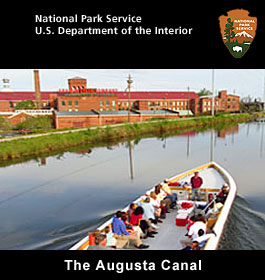
In the 21st Century the Augusta Canal is once again a source of pride and potential for its community. The mighty Enterprise Mill, revived after years of neglect as an office and residential complex, now houses the Augusta Canal National Heritage Interpretive Center. Its exhibits and artifacts depict canal construction and mill life and remind Augustans and visitors alike of the progress, problems and promise of the Augusta Canal.
Source: Edward J. Cashin,
“The Brighest Arm of the Savannah: the Augusta Canal 1845-2000,”
(Augusta, Augusta Canal Authority 2002)
Geography
The Augusta Canal was built in three levels. The first level begins at the Headgates located at Columbia County’s Savannah Rapids Park. This level reaches 7 miles. terminating at gates a 13th Street near Walton Way, just north of the University Hospital main campus. The towpath trail which runs along the north side is limited to pedestrians/cyclists from the headgates to the Augusta Waterworks Raw Water Pump Station at the end of Goodrich street. Goodrich Street parallels the canal to King Mill.
The canal’s second and third levels wind thru downtown and are less visible and accessible that the first level. The Second level branches from 13th Street toward the northeast, where it intersects with the third level near 11th and Telfair Streets, adjacent to Davidson Fine Arts Magnet School. From there, the Third level flows in two directions: northwest toward Hawks Gully at 15th Street where the water re-enters the Savannah River, and southeast, where it flows into Beaver Dam Creek. Currently, the Third Level is undergoing restoration.
Environment
Although the Augusta Canal is man-made, many areas along its banks have returned to a more natural state. The canal occupies a unique ecosystem created along the granite ledges that separate the Piedmont plateau from the Coastal plain –an area known as The Fall Line. The undeveloped land between the canal and the Savannah River rapids along the upper First Level has formed a wetland, creating an urban wildlife refuge that is home to varied flora and fauna, including several rare and endangered species.
Costs
Prices for the 1-hour tours include Canal Interpretive Center admission. $12 adult, $10 Senior (65+), Military, Student (age 4 through Grade 12 or with college ID) , Children age 3 or younger free with adult or senior. Group rates and Center-only admission tickets available. Call 706-823-0440 ext. 4 for information and reservations.
Operating Hours & Seasons
Augusta Canal Interpretive Center:
•Regular Season (March- November) Mon to Sat, 9:30 a.m. – 5:30 pm., Sunday 1- 5:30 p.m.
•1-hour boat tours Monday-Saturday, 10:00. 11:30, 1:30, 3:00; Sunday: 1:30, 3:00
•3-hour sunset tour (times vary by time of year): Mar - Nov. Call to schedule 706-823-0440 ext 4
•Winter Season (December – February) Tuesday to Saturday, 9:30 a.m. – 5:30 pm.
•1-hour boat tours Monday-Saturday, 11:30, 1:30, 3:00
•Headgates at Savannah Rapids Park: Year round, daily, daylight hours.
Fees & Reservations
No charge to visit Park or use trails.
Canal Interpretive Center and Boat Tours are ticketed attractions. Boat tour reservations are strongly encouraged. Call 706-823-0440 extension 4.
• Adult (19-64 years): Center admission only $6. 1-hour Boat tour (includes Center admission) $12, 3-hour tour $20,
• Senior (65 and over), Military, Student (pre-K-12 grade and college with current I.D.): Center admission only $4. 1-hour boat tour (includes Center admission) $10, Three-hour tour $18, (Three-hour sunset tour not recommended for young children.)
• Child (under 4 years): 1 free with paid admission. Small children not permitted on 3-hour tour.
Contact and Address Info
Phone: 706-823-0440 ext. 4, 800-659-8926 Address: 1450 Greene Street, Suite 400, Augusta, GA 30901
Directions
Canal Interpretive Center
1450 Greene Street, Augusta, from Interstate 20, Exit 200 Riverwatch Parkway:
Left on Riverwatch approx. 5 miles to 13th St. Right on 13th St (0.1 mi.) to Greene St. Right on Greene (0.3 mi.) to Enterprise Mill. Canal Interpretive Center Entrance on West (far) side of Mill.
Headgates At Savannah Rapids Park
Terminus of Evan-to-Lock Road. Evans, Georgia
From I-20 Exit 200-Riverwatch Parkway. Right on Riverwatch approx. 1 mile to light at Stevens Creek Road. Right on Stevens Creek. 2 miles to 4-way stop on Evans-to-Lock Road. Turn Right. Road ends at park entrance (0.8 mi.). Paved parking is available.
Interesting Augusta Canal Facts
Congress has established 40 National Heritage Areas around the country in which conservation, interpretation and other activities are managed by partnerships among federal, state, and local governments and the private sector.