Welcome to www.n-georgia.com 
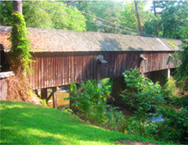
Discover Georgia's Concord Covered Bridge - Located in Smyrna, Concord Covered Bridge was built in 1872 over Nickajack Creek in Cobb County. Historical marker available. Description, directions, map, phone number and picture are below. Stay and Play in GA!
Free Stuff To Do In Georgia Georgia Overnight Accommodations Shopping in Georgia Videos of places and things to do in Georgia Georgia Department of Labor Weather in Georgia Maps of places in Georgia Contact Us Advertise in N-Georgia.com

N-Georgia.com Website

Georgia's 9 Travel Regions

ADA Access Locations
Georgia Monthly Festivals and Events
Georgia Festivals and Events
Georgia State Parks
Georgia County Parks
Georgia Wildlife Resources Division Areas
Georgia WRD Archery and Firearms Ranges
Georgia U. S. Forests
Georgia National Parks Services
National Parks Services Augusta GA Historic Sites
NPS Georgia Coast and Islands Historic Sites
Georgia Horseback Riding Trails
Georgia Mountain Bike Trails
Georgia Off Highway Vehicle Trails
Georgia Driving Tours
Georgia Covered Bridges
Georgia Waterfalls
Georgia Lakes
Georgia Fishing Lakes
Georgia Rivers
Georgia Coast and Islands
Georgia Planetariums and Observatories
Georgia Audubon Society
Georgia Farmers Markets
Georgia Gardens
Georgia Historic Sites
Georgia Civil War Sites
Georgia Museums
Miscellaneous Fun Activities
Outdoor Safety Tips
Georgia Tourist Centers
Georgia Visitor Centers
Concord Covered Bridge
Concord Covered Bridge - Phone: 770-933-7228 - Concord Rd., Smyrna, GA (Cobb Co.)
Bridge Description: Concord Bridge is 131.7 feet long and 16 feet wide. It was built in 1872. This bridge is open to traffic. It is over Nickajack Creek. There is a historical marker at this bridge.

Concord bridge has become the focus of the Concord Covered Bridge Historic Area. An old railroad bed, including a few bridges, in the area has been converted to a dedicated bike trail as part of the PATH Foundation's Silver Comet Trail. Even the bridges along the nearby East-West Connector have been given a timber motif.

This historic area also has remnants from Ruff's Mill, the scene of a Civil War battle. Ruins of the dam are still upstream of the bridge as well as parts of the grist mill. The miller's house is still a residence.

Though historically it has the highest traffic count of all the covered bridges in the state combined, the count has diminished with completion of the East-West connector. Nonetheless, repairs were expedited and completed ahead of schedule to get this bridge back in service as soon as possible. Note: Fast and high traffic makes a visit to this bridge dangerous.

This bridge originally consisted of only two spans, each a queen-post truss with steel (or iron) tension rods. The center abutment, as can be seen in the photo of the steel beams above, seems to have been widened from a previous bridge using the same pier.

In the 1950's steel beams were added to support the bridge and additional concrete piers were added. There is also a fourth all-steel support which can be seen in the downstream view.

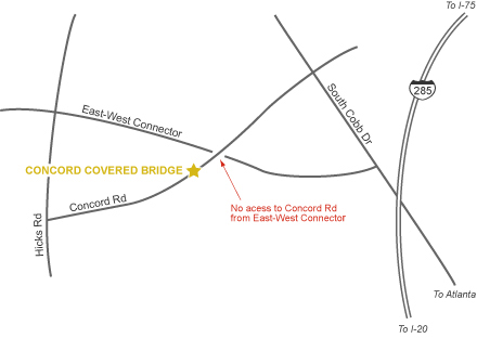
Directions: From Atlanta, take I-75 north to I-285 west. Take Exit 15 (South Cobb Drive), and go 7 miles to Smyrna and 2 1/2 miles southwest on Concord Road. In Kennesaw Mountain National Battlefield in the Metro Atlanta Travel Region.
Concord Covered Bridge Map
Custom Search

Online Georgia Covered Bridges Map
Georgia covered bridges online map.

Printable Georgia Covered Bridges Map
Georgia covered bridges printable map.

Bullet

Georgia Covered Bridges

Atlanta Travel Region Map and Info
Atlanta Travel Region Printable Map

Bullet

Metro Atlanta Activities
BulletState Parks-Historic Sites
BulletFestivals & Events
BulletFree Indoor Activities
BulletFree Outdoor Activities
BulletFun Activities $5 & Under
BulletTourist Centers
BulletTravel Region Info

HomeFree Stuff To Do - Festivals & Events - Monthly Events - State Parks - County Parks  - Georgia National ForestsWildlife Areas    
WRD Archery & Firearms Ranges - National Parks Services Sites - Horseback Riding Trails - OHV Trails - Bike Trails - Driving Tours
Covered Bridges - Civil War Sites - Historic Sites - Augusta NPS - Coastal NPS - Museums - Coast & Islands - Rivers - Lakes - Fishing Lakes - Waterfalls - Gardens - Planetariums - Audubon Society - Farmer Markets - Misc. Fun - ADA Access - Travel Regions - Tourist Centers
Visitor Centers - Maps - Videos - Safety Tips  - Lodging - Shopping - Dept of Labor - Weather - Advertising  - Privacy Policy -  Contact

Website created and Copyright ©2010 by Sandy's Grafix. All rights are reserved. Website updated on 4/24/2010