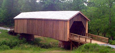
www.n-georgia.com - Georgia's Recreation and Adventure Guide

Georgia's Online Outdoor Recreation and Adventure Guide - www.n-georgia.com

Discover Georgia's beautiful parks, wildlife, mountains, waterfalls, lakes, coast and islands, Civil War and historic sites, gardens, trails, festivals, and other fun places to visit.  Whether you are going out for a day or vacationing in Georgia, this site is full of outdoor recreational ideas and maps at your fingertips.  Relax, browse around and get ready for good times in Georgia.
Lodging Accommodations in GeorgiaGeorgia ShopsGeorgia RestaurantsGeorgia Real EstateCoupons for Georgia Businesses
Home Search Website Monthly Events Festivals & Events State Parks Golf Courses County Parks National Forests Wildlife Areas Horseback Riding Bike Trails OR Vehicle Trails Covered Bridges Driving Tours Waterfalls Lakes Coasts & Islands Planetariums Audubon Society Gardens Farmers Markets Historic Sites Civil War Sites Museums/Galleries Miscellaneous Fun Tourist Centers Maps/Directories Videos Contact/Feedback 9 Travel Regions Free Stuff To Do
   

Georgia Flowers at Bridge

Discover Georgia's Historic Covered Bridges
The Covered Bridge Trail of Georgia, Inc. was founded in 1998 to preserve and promote the last 15 of the many covered bridges that once existed in Georgia.  Some are still open to car traffic.  Covered Bridges Interactive MapReturn to Covered Bridges.
Georgia Covered Bridges Printable Map
Click here for a
Printable Map
 
Auchumpkee Bridge in Thomaston, Georgia. State Visitor Headquarters. Not open to traffic. It is 96 feet long. Also known as Zorn's Mill. 
General Info
Blue BulletCounty: Upson
Blue BulletOther names: Hootenville Bridge
Blue BulletLength: 96 ft.
Blue BulletBuilt: 1892, rebuilt 1997
Blue BulletBuilder: W. Alford/Dr. J. Herring
Blue BulletTruss: Town lattice
Blue BulletStream: Auchumpkee Creek
Blue BulletRoad name: Adjacent to Allen Road
Blue BulletTraffic: No
Blue BulletParking: Yes
Blue BulletPicnic area: Yes
Blue BulletHistoric marker: No
Blue BulletOwner: Upson County
Auchumpkee Creek Covered Bridge Map
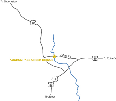
Directions: From 1-75 south in Atlanta, take exit 77 to Hwy. 19/41 to Griffin, Zebulon and Thomaston. Go 12 miles south of Historic Square on Hwy. 19 to Allen Road. At Sprewell Bluff State Park in the Presidential Pathways Travel Region.  Call 800-821-4228 or 706-646-2437.
Monthly Events     Festivals, Fairs & Events     State Parks     County Parks     Wildlife Areas     National Forests   

Golf Courses     Horseback Riding     ORV Trails     Bicycle Trails     Driving Tours     Coasts & Islands     Lakes     Waterfalls

Gardens     Audubon Society     Covered Bridges     Civil War Sites     Historic Sites     Museums & Art Galleries

Planetariums     Farmers Markets     More Georgia Fun     Maps     Tourist Centers     Accommodations     Videos Online Georgia Videos 

Free Stuff To Do     9 Travel Regions      Visitor Information Centers     Real Estate     Shopping     Restaurants

Safety Tips     Advertising Opportunities     Contact     Home

  
This website was created by Sandy's Grafix.   Copyright 2007 by Sandy's Grafix.  All rights reserved.

It was last updated on February 1
, 2007.