|
| Stonewall Falls & White Twister Bike Trail General Information |
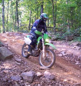
 Rated moderate on difficulty, the Stonewall Falls & White Twister Bike Trails offer cyclists and hikers alike a rewarding 7.8 mile loop on a dirt trail, criss-crossing the Stonewall Creek. The forest provides a canopy which provides shade and relief from summer heat. This trail is also a favorite for night-riding. Rated moderate on difficulty, the Stonewall Falls & White Twister Bike Trails offer cyclists and hikers alike a rewarding 7.8 mile loop on a dirt trail, criss-crossing the Stonewall Creek. The forest provides a canopy which provides shade and relief from summer heat. This trail is also a favorite for night-riding.
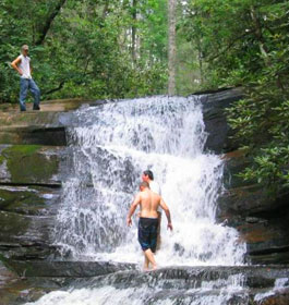
The Saga Mountain lookout point provides an awesome view of mountains including Rabun Bald (Georgia's second highest mountain), Standing Indian, Tiger Mountain and Black Rock Mountain. The White Twister Trail gets its name from the 4.5 miles of winding, twisting, roller coaster route it flows. Enjoy stunning views of the Stonewall Falls and the cooling, protective canopy of the forest on this exciting and rewarding trail.
White Twister: This 4.5 mile moderately difficult loop is located in the Stonewall Falls mountain bike area. The White Twister winds through the mountains and alongside Stonewall Creek, and boasts a few challenging climbs. The trail has been nicknamed "the roller coaster trail" due to the numerous rolling areas. It travels through Fern Valley and along Root Ridge before connecting to the old railroad bed. The trail runs 1/2 mile in the old railroad bed and back to the beginning. For a more challenging ride, do it backwards. Directions to the White Twister are the same as Stonewall. |
|
Stonewall Falls: The Stonewall Falls Trail now offers more challenges and greater distance than before. The trail is now considered by bikers as a true mountain bike trail and mountain bikers appreciate its challenge and the enjoyment it provides. With nearly 7.5 miles of new single-track (Total Distance = 11 Mile Loop), which results in the best mountain biking has to offer in northeast Georgia. By design, it is not the easiest trail in the area, but it is considered to be what a "true mountain bike trail should be". At mileage 3.4 miles there is an optional exit to allow bikers to exit and return to the parking lot via the power line access road, rather than continue on the trail. There are optional routes along the trail with different difficulty levels. There is a good possibility of seeing wildlife in this area. Wildlife ranges from squirrels, grouse, deer, bobcats, and even wild bear.
Note: There is no charge to ride on this trail system.
Nearest Town: The nearest town is Clayton, GA, which is approximately 5 miles North, and 10 minutes from the start of the trail. Here visitors will find restaurants, grocery stores, gas stations, etc.
Open: All year
Water: none - Restroom Facilities: none |
| Contact & Directions |
USDA Forest Service, Chattooga River Ranger District office - Phone: 706-754-1021 Address: 9975 Highway 441 S, Lakemont, GA 30552 - Hours: Monday - Friday at 8 am - 12 Noon and 1-4:30 pm. Closed 12 Noon until 1 pm.
Chattahoochee-Oconee National Forests - Phone: 770-297-3000
Address: 1755 Cleveland Highway, Gainesville, GA 30501
Office hours: Tuesday - Friday at 9 - 12 & 1-4 - Closed Saturday, Sunday, and Monday |
| Directions: Coming from the south, take 441 North until you pass the Chattooga River Ranger District Office (9975 Hwy 441 S.). Go another 2-3 miles until Rabun County High School is seen on the right hand side of the road, and immediately look to the left for Boggs Mountain Connector. Take this road to it's first intersection (almost immediate) and turn left onto Old 441. Take your second right onto FS Rd. 20 (also Stone Wall Rd.). Continue straight on dirt road until you see the falls and dispersed camping on your left. Trails begin just past the falls on the right. |
|
| |
|
Georgia US Forest Areas
 Camping Hiking Camping Hiking
Horseback Riding Trails
FishingCanoe Trails
GA US Forest Wilderness
Wilderness Preparation
Canoe Safety Tips
Forest Safety Tips
GA U S Forest History

|