|
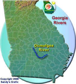
Below Macon, the character of the river changes dramatically as the floodplain widens to produce the shifting channel meandering characteristic of the upper Coastal Plain. The Ocmulgee River from Lloyd Shoals Dam to Hawkinsville has two characteristics, delineated by the Fall Line and providing distinctly different fishing opportunities.
Anglers in central Georgia have the unique opportunity to experience each within a short drive from Macon, Warner Robins or Perry River in south Georgia, and it is worthy of a visit. |
| Best Fishing Bets |
| Shoal bass, channel catfish, flathead catfish, redbreast sunfish and American shad |
| Upper Ocmulgee River Fishing Tips |
Striped Bass - These stocked stripers should average 21 inches and 4–5 pounds. Some stripers that escape into the river below Lloyd Shoals Dam may reach 30 pounds in the next 5-8 years. Additional sources of striped bass are escapees from Lake Juliette, below Juliette Dam, where they have been stocked for 10-plus years and from more recent stockings in the lower Altamaha associated with a basin-wide restoration project.
Technique - Larger jigs cast into swift current or live shad fished in deeper areas near dams are usually most productive.
Target - The most productive areas are the quarter mile reach below the Juliette Dam and just below the weir in the Lloyd Shoals Dam tailrace. Spring is the prime season for striper fishing. |
|
Shoal Bass were stocked in the upper Ocmulgee River during the 1970s where they are now as abundant as the native Flint River population. Most shoal bass caught in the upper Ocmulgee will be 12-16 inches, with a few 16-18 inches. The occasional 18 to 20-inch lunker also is available. The best fishing is in May through June and again in the fall.
Technique - Small to medium swimming minnows, spinner baits, poppers and artificial worms are preferred. For fly-fishing, bring along plenty of wooly buggers and medium poppers. Wade fishing shoals may be the most productive method, but drift fishing from canoe or kayak is also effective.
Target - As a first choice, target the area of alternating shoals and flat water reaches between Highway 16 and Wise Creek. This area may provide one of the best angling experiences in the state, but any stretch of river with shoals from Lake Jackson to Macon will contain shoal bass. |
Spotted Bass stocked into Lake Jackson by anglers in the 1990s are now found in the upper Ocmulgee above Lake Jackson to the Warner Robins area. Expect the average spot to be slightly smaller than shoal bass.
Techniques used for shoal bass and largemouth bass are also effective for spotted bass.
Target areas near Lloyd Shoals Dam with moderate current. Also look to the area of alternating shoals and flat water reaches between Highway 16 and Wise Creek, and in the Hwy 83 area. Spotted bass are probably more aggressive than other black bass species and are found in a wider range of habitats than largemouth bass or shoal bass. |
Bream - The upper Ocmulgee River has excellent populations of redbreast sunfish, bluegill and redear sunfish (shellcracker). Redbreast will average 5 inches, bluegill 5-6 inches and redear sunfish 8-9 inches. The exotic longear sunfish has increased in abundance over the last several years, and is generally considered a nuisance. These colorful sunfish average just under 4 inches.
Technique - For redbreast: Crickets are the traditional bait, but ultra light tackle with small spinners or fly-fishing with small poppers or spider imitations sometimes can be just as productive. Bluegill can be caught using the same techniques used for redbreast. For redear: Try fishing on the bottom using worms, as they rarely take artificial baits.
Target - For redbreast: Target areas of swift to moderate current except during the spring spawning season when they bed in large numbers in calmer water. The area of alternating shoals and flat water reaches between Highway 16 and Wise Creek are good bets. Also, expect to find good populations of redbreast near any shoal throughout the lightly fished area between the Juliette Dam and Macon. For bluegill and redear: The half mile reach below Lloyd Shoals Dam provides some of the best fishing in the river. Bluegill and redbreast also are abundant below Macon. May through June are the most productive months in this reach. Redear are caught in large numbers only during the spring spawning season when they bed near shore, in calm water. |
|
Largemouth Bass - The predominate black bass below Macon. Largemouth in this area average 12-15 inches, with good numbers between 15-20 inches, and about 10 percent reaching 20-25 inches. A good population of largemouth is also found above Macon, but they average slightly smaller and most anglers in this area target shoal bass.
Technique - Expect good catches with the right techniques. Fool largemouth with a lightly weighted plastic worm or lizard cast close to the snags. Spinner baits, medium rapala-type crankbaits, plastic jerk baits and topwater plugs also are effective. The key is getting the lure deep into the cover.
Target the calmer waters along the banks around snags in the area of the river below Macon. |
Catfish - Channel catfish are abundant throughout the river and flathead catfish introduced into the upper Ocmulgee in the 1970s have spread throughout most of the Altamaha basin. Recent sampling indicates the presence of flathead catfish above Juliette Dam, and numbers in the area are likely to increase over the next several years. Flatheads are especially abundant in the Coastal Plain section of the river below Macon.
Technique - Rod and reel fishing can be effective for channel catfish, but also try trotlines or bushhooks baited with prepared baits, liver, crayfish and a variety of home recipes. The same gear is effective for flatheads, but live baits must be used. The most effective bait is a medium-size redbreast or bluegill.
Target - Fish the river below Macon where catfish are most abundant. The more productive areas are deeper holes with structure in meandering sections. |
Other Fish Species - Fishing for American shad is as popular as bass fishing in some parts of the country, but receives little attention in Georgia. Expect the average shad to measure 20 inches and weigh a little over 2 pounds. Find shad below Juliette Dam from March through May, but the peak is during the April spawn.
Technique - Fish are concentrated near the dam in large enough numbers to use spinning tackle with "shad darts" or on a fly rod with small streamers.
Target - Look to the area below Juliette Dam. |
|
| Contact Info |
| Wildlife Resources Division, Fort Valley Fisheries office - Phone: 478-825-6151 |
|
|
|
Visit:

 Georgia Lakes Georgia Lakes
WMA Public Fishing Areas
GA Fishing Lakes
Georgia Rivers & Map
GA Lakes & Rivers Map
Water Safety
|