|
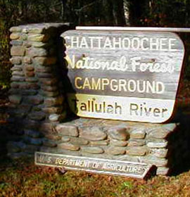
| Tallulah River Campground & General Information |
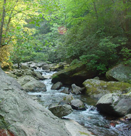
This scenic campground is at an elevation of 2,080 feet, in the foothills of the Blue Ridge Mountains in NE Georgia. Rugged mountain scenery and the Tallulah River plunging by make this a beautiful place to camp, fish or hike.
 Located on the bank of the popular Tallulah River, this campground offers superb scenery and ambiance, earning it a "favorite" rating by locals. Whether looking for a place to relax and roast marshmallows with Fido and the family, or go exploring on one of the numerous adjacent hiking trails with a pal, rafting, paddling or planning on visiting neighboring sites like Moccasin Creek State Park, this campground has something for everyone. Good, hard-surface roads until you reach Forest Service Road 70; expect narrow gravel road that is crooked and steep in parts. Located on the bank of the popular Tallulah River, this campground offers superb scenery and ambiance, earning it a "favorite" rating by locals. Whether looking for a place to relax and roast marshmallows with Fido and the family, or go exploring on one of the numerous adjacent hiking trails with a pal, rafting, paddling or planning on visiting neighboring sites like Moccasin Creek State Park, this campground has something for everyone. Good, hard-surface roads until you reach Forest Service Road 70; expect narrow gravel road that is crooked and steep in parts.
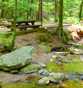
Campground Amenities: 17 large, graveled tent and/or RV sites (approx 10' × 98') positioned on fairly level and wooded forest land, come equipped with picnic tables, grills, and lantern poles. There are 3 RV pull-throughs for your convenience. This pet friendly campground has 7 water spigots, a public phone, interpretive signage, restrooms accessible to those with disabilities and security. There are no RV hookups available. This campground is accessible to those with disabilities.
Reservations Reservations are not required. Campsites are on a first come, first serve basis.
Fees: $15 per campsite site per night, year round. Free to visit during the day.
Permit Info: Georgia fishing license and trout stamp are required for fishing. |
|
Restrictions: The maximum length of stay is 21 days.
Open: Year round
 Closest Town: The nearest town is approximately 30 minutes southeast in Clayton, GA. Here campers will find restaurants, grocery stores, etc. Closest Town: The nearest town is approximately 30 minutes southeast in Clayton, GA. Here campers will find restaurants, grocery stores, etc.
Water: Drinking water from hand pumps are strategically placed throughout grounds.
Restroom Facilities: 2 Chemical flushed facilities
Passes: The Interagency Senior and Access Passes and the Golden Age and Access Passports are accepted. These passes entitle the pass holder to a 50% discount on camping fees.
Operated By: Chattahoochee Management, INC. under permit by the US Forest Service. You can visit their website, www.chattahoocheemanagement.com
More Recreation Activities
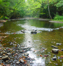
River & Stream Fishing - This river is routinely stocked with Rainbow Trout! Please remember that the State of GA fishing licence and Trout Stamp are required for anyone over the age of 16.
Day Hiking - Coleman River Scenic Area: very popular with campers due to its close vicinity and ease of access. The Coleman River Trail parallels the river for 1 mile through stands of large old-growth forest, and if your lucky you'll even catch a glimpse of thrill-seeker whitewater rafting!
Swimming - There are multiple opportunities for wading or swimming. |
|
| Contact, Directions & GPS Location |
USDA Forest Service, Chattooga River Ranger District office - Phone: 706-754-6221 or 770-490-1246 - Address: 9975 Highway 441 S, Lakemont, GA 30552 - Office hours: Monday - Friday at 8 am - 12 Noon and 1-4:30 pm. Closed 12 Noon - 1 pm.
Directions: Take U.S. 76 west from Clayton for 8 miles; turn right (north) Persimmon Rd. (a paved county road) for 5 miles; turn left (northwest) on Forest Service Road 70 for 1 mile to Tallulah River (another 3 miles to reach Tate Branch and another 5 miles to Sandy Bottom).
GPS Location for Tallulah River Campground - Latitude is 34.927176 and Longitude is -83.543205. |
| |
|

Georgia US Forest Areas
 Camping Hiking Camping Hiking
Horseback Riding Trails
FishingCanoe Trails
GA US Forest Wilderness
Wilderness Preparation
Canoe Safety Tips
Forest Safety Tips
GA U S Forest History

|