Discover Spring Creek Wetlands Preserve in Dalton Georgia
This 200-acre water quality and wildlife habitat area is maintained by Dalton Utilities.
General Info
The wetlands preserve compensates for streams and wetlands that were altered or destroyed by construction of the Haig Mill Water Reservoir. The preserve is located along Spring Creek, which originates about one mile upstream at Deep Springs in northwest Whitfield County and flows downstream to the Conasauga River.
The Spring Creek Wetlands Preserve was created under a Protective Covenant, which means the property will remain protected forever, regardless of future events or change of ownership. The Preserve is open to the public at no charge. A trail system runs through the wetlands on both the east and west sides of Spring Creek. Visitors are encouraged to observe the plants and wildlife with convenient brochures and trail markers.
Free admission and parking.
Hours of Operation - Gates are open for self-guided tours on Saturday and Sunday from 9 a.m. to 6 p.m. The preserve is open by appointment only on weekdays. For information, call Dalton Utilities at 706-278-1313.
Location: Boyles Mill Rd., Dalton Georgia 30720 - Directions: Take I-75 to Walnut Avenue Exit (#333). Head east on Walnut Avenue. Turn left onto Hwy 286 (Lower Dawnville Road). When the road forks, bear left onto Lower Kingsbridge Road. Once you cross a bridge, take the first left at the four-way stop onto River Road. Take an immediate left onto Boyles Mill Road. The entrance and parking lot for Spring Creek Preserve will be on the right.
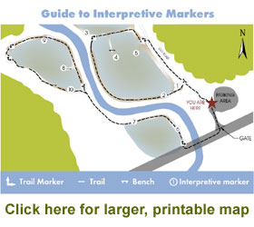
Guide to Interpretive Markers
The Eastern Trail
1. Old Mill Race. This channel was excavated around 1870 to carry water from a small dam on Spring Creek to a gristmill owned by Wilson Norton. The water turned an undershot wheel which turned the grindstones to produce flour. One of the foundation walls from the mill may be seen behind you. The mill was operated until sometime in the early 1900s. In order to restore wetlands on the floodplain, the mill race had to be blocked and breached, thereby allowing high flows to spill out mill race and flood the abandoned farmland.
2. Spillway and Berm. The raised path on which you are walking is a berm that was constructed to help retain floodwaters in the restored wetland. The spillway in the berm allows extremely high water to drain back into Spring Creek without eroding the berm. The small piece of PVC pipe is a piezometer used to periodically measure water levels in the wetland.
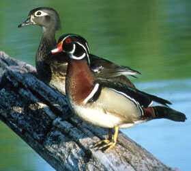
3. Riparian Zone. The area next to a stream is called the riparian zone. Notice that trees and shrubs are growing in the riparian zone along Spring Creek. These trees and shrubs prevent the streambanks from eroding, provide a corridor for birds and other wildlife to move around under cover, and provide shade to keep the stream cool. If you remain still and quiet, you may hear songbirds singing or see wood ducks flying through the trees in the riparian zone.
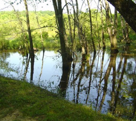
4. Constructed Wetland. The observation berm is in the middle of an area that used to be pasture. The mill race diverted floodwaters around the pasture, effectively draining it. Wetland was restored by breaching the mill race and constructing the low berm to retain floodwaters. The mill race breach can be seen to the east. Old stumps and trees were dragged into the wetland to provide homes and perches for birds and reptiles. Like most swamps in north Georgia, this wetland floods frequently during the late winter and early spring but dries up for much of the summer.
5. Wetland Wildlife. Wetlands are full of animal and plant life. The deeper areas host small fish, such as largemouth bass fry, and invertebrates, such as dragon fly larvae, which live underwater for two years before emerging and growing wings. Shallow water areas are homes for mud turtles and green frogs. Great blue herons and green-backed herons wade through these waters searching for fish, frogs and crayfish to eat. If you sit quietly, you may hear frogs calling, see fi sh swimming in the channel or see birds and insects flying by.
The Western Trail
To reach the western trail, return to the parking area, walk out to Boyles Mill Road and turn
right. Cross the bridge over Spring Creek, and walk along the right-hand side of the road until you reach a trail marker and a set of steps on your right. From the top of the steps, you can see the western portion of the wetland restoration site and trail.
6. Constructed Wetland. In order to construct the wetland, the floodplain had to be
excavated three feet deep. Now, when floodwaters flow onto the floodplain they pond in this shallow depression. The low berm keeps the water from draining away too rapidly, but the spillway insures that the water is not too deep for plants to grow. The mounds of dirt in the ponded area were placed there so that trees and other plants that like moist soil but do not want to be flooded would have a place to grow. These mounds also provide places for turtles to sun themselves and for herons to stand while hunting fish.
7. Spring Creek. This spillway allows water to flow into the bermed area when Spring Creek floods. The water in Spring Creek is clear and cool because swamps and a forested riparian zone upstream fi lter out sediment and other pollutants. Notice the many snails crawling on the bottom of the creek. These can be an important food source for turtles and fish. Some of the fish in Spring Creek include catfish, bream, crappie, redeye bass and rainbow trout (stocked by the Georgia Department of Natural Resources).
8. Wetland Plants. Plants growing in wetlands are specially adapted to growing in fl ooded areas or in extremely wet soils. Common wetland plants include broadleaved arrowhead, cattail, and many types of sedges (a grass-like plant). Many tree seedlings have sprouted, including overcup oak, swamp chestnut oak, red maple, and green ash. Eventually, as the trees grow, this area will become a forested swamp.
9. New Swamp From Old Swamp. Upstream from this point, the floodplain along Spring Creek was not cleared for farming and much of the original forested swamp remains. The constructed wetlands will become natural wetlands much faster because of interaction with the swamp upstream. When the creek floods, many types of plants, roots, and seeds are washed from the old swamp, through this spillway, into the constructed wetlands. Even small fi sh are washed into the constructed wetlands. Also, birds, such as woodcock, that have been living in the old swamp will move into the constructed wetlands as the trees grow.
10. Deep Water. Wetlands are full of plants and animals because they provide a mix of many different living conditions – permanently flooded areas, temporarily flooded areas, damp soil areas, forests, open field and many other habitats. The small ponded area to the right (east) has water up to 2 feet deep, even when other parts of the wetland are dry. This pond provides a place for fish, amphibians and other animals to move to so that they can survive droughts.
Wildlife
The wetlands preserve is home to a wide variety of wildlife, including wood ducks; reptiles; turtles; snails, small fish, such as largemouth bass; and invertebrates, such as dragon fly larvae, which live underwater for two years before emerging and growing wings.
Shallow water areas are homes for mud turtles and green frogs. Great blue herons and green-backed herons wade through these waters searching for fish, frogs and crayfish to eat. If you sit quietly, you may hear frogs calling, see fish swimming in the channel or see birds and insects flying by. Some of the fish in Spring Creek include catfish, bream, crappie, redeye bass and rainbow trout (stocked by the Georgia Department of Natural Resources). Wetland plants include broad-leaved arrowhead, cattail, and many types of sedges (a grass-like plant). Many tree seedlings have sprouted, including overcup oak, swamp chestnut oak, red maple, and green ash. Eventually the trees will grow up and this area will become a forested swamp.