|
|
Yahoola Trails Conservancy (YTC) have helped the Dahlonega-Lumpkin County Chamber of Commerce & Visitors Center launch a complete and accurate guide to “HIKING TRAILS IN THE DAHLONEGA AREA: 22 Trails in the N Georgia Mountains within 32 miles of Dahlonega.” |
 The “Hiking Trails…” Guide has directions to start each trail from the downtown Dahlonega-Lumpkin Visitors Center. The user-friendly Guide key includes each trail’s name, the trail’s length, whether it is a loop or one-way, and the managing agency of the trail as well as a fun note that “descriptions shown are for the more common hiking direction used, but there is no reason not to hike in the opposite direction”. The “Hiking Trails…” Guide has directions to start each trail from the downtown Dahlonega-Lumpkin Visitors Center. The user-friendly Guide key includes each trail’s name, the trail’s length, whether it is a loop or one-way, and the managing agency of the trail as well as a fun note that “descriptions shown are for the more common hiking direction used, but there is no reason not to hike in the opposite direction”.
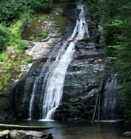
The Trails include close to town options such as the Lake Zwerner Trail (Dahlonega Reservoir) Loop, the Yahoola Creek Park Trail System, and Jake & Bull Mountain Trail System, and as far out as Helton Creek Falls, the Sosebee Cove Scenic Area, and various trails at the Cooper Creek Recreation Area.
The information includes a 32 mile radius of hiking opportunities from portions of the official Appalachian Trail, and other US Forest Service areas, and scenic selections from both Lumpkin County and Georgia State Park areas.
“One of our goals was to provide the outdoor adventure seeker interest market with readily available, up-to-date, and accurate recreation information for hiking the Dahlonega area,” said Jay Markwalter with the Chamber Tourism office. “A guide to Hiking Trails is one of the top 10 walk-in visitor inquiries at our downtown Dahlonega regional Visitors Center. We needed an updated resource guide and map for hiking enthusiasts.
Thanks to the YTC volunteers Tom Lamb, Murray Lamb, and Robert Fuller, we now have a nine-page hiking guide to enjoy our beautiful mountain terrain for a day, long weekend, vacation, or repeat visitor challenge to return and complete the full 22-trail list.” |
|
How to get the hiking trails free guide - The “Hiking Trails” guide is available at the Visitors Center and for download at Dahlonega.org found at What To Do : Hiking & Backpacking.
The YTC says this assistance is just Phase I of a project to compile canoeing, kayaking, mountain biking and horseback riding trail guides for visitors and locals. This initial Hiking Trails guide also lists contact information for the local, state, and US Forest Service district offices as well as nearby medical facilities.
As presented on the Guide, the information is compiled and prepared for the Dahlonega-Lumpkin County Visitors Center (www.dahlonega.org) by the Yahoola Trails Conservancy (www.yahoolatrailsconservancy.org) and the Dahlonega Trail Fest (www.DahlonegaTrailFest.org) Click here for a .pdf map of this trail. Click here for a .pdf trail quide book. |
Media Contact: Jay Markwalter, Dahlonega-Lumpkin Visitors Center, (706)864-3513 Jay@Dahlonega.org
Additional Info Contact: Tom Lamb, Chair YTC & Trail Fest - info@dahlonegatrailfest.org |
|
|
|

|