|
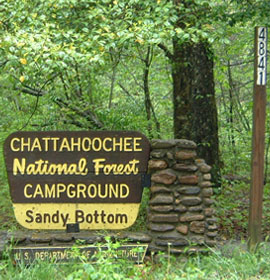
| Sandy Bottoms Campground & General Information |
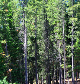
Explore rugged, majestic mountain scenery and the Tallulah River plunging. This is a beautiful place to camp, fish and hike. The area offers 12 camp sites with picnic tables, grills and tent pads. The Tallulah River offers good trout fishing. Hiking through nearby Coleman River Scenic Area is popular. The Coleman River Trail parallels the river for 1 mile through stands of large old-growth timber. Drinking water is available.
 The Coleman River Trail parallels the river for 1 mile through stands of large old-growth timber. Good, hard-surface roads until you reach Forest Service Road 70; expect a narrow, gravel road that is crooked and steep in parts. Whether you plan your trip during the rebirth of Spring or later in the year during the display of the prominent North Georgia Fall colors, this 14-site developed campground is sure to heighten the innate beauty of any season. The Coleman River Trail parallels the river for 1 mile through stands of large old-growth timber. Good, hard-surface roads until you reach Forest Service Road 70; expect a narrow, gravel road that is crooked and steep in parts. Whether you plan your trip during the rebirth of Spring or later in the year during the display of the prominent North Georgia Fall colors, this 14-site developed campground is sure to heighten the innate beauty of any season.
Graced with various species of hardwoods and resting on the shore of the Tallulah River, Sandy Bottoms provides a rustic experience for the outdoor enthusiast to camp, swim, fish or just to sit back and enjoy the scenery.
Campground Amenities: 14 camping sites. Graveled driving loop thru recreation area.
Campsites include tandard amenities like a grill, picnic tables, lantern poles, etc.
Reservations Reservations are not required. Campsites are on a first come, first serve basis. |
|
Fees: Camping is $15 per site per night.
Permit Info: Georgia fishing license and trout stamp required for fishing.
 Restrictions: The maximum stay is 21 days. Restrictions: The maximum stay is 21 days.
Open: Mid-March until October 31. Open 24 hours a day. Quite hours are 10pm - 7am.
Closest Town: The nearest town is approximately 22 miles, or 35 minutes, to Clayton, Georgia. Here, you will find restaurants, grocery stores, etc.
Water: Drinking water is provided from one, centralized hand pump.
Restroom Facilities: 1 Chemical Flush facility
Passes: The Interagency Senior and Access Passes and the Golden Age and Access Passports are accepted. These passes entitle the pass holder to a 50% discount on camping fees.
Operated By: Chattahoochee Management, INC. under permit by the US Forest Service
More Recreation Activities
Day Hiking - Coleman River Trail. The trail's length is 1 mile.
River and Stream Fishing - The Tallulah River is routinely stocked with Rainbow Trout. Please remember that the State of Georgia fishing licence and Trout Stamp are required for anyone over the age of 16. Fishing regulations and information are available from the Georgia Wildlife Resources Division. |
|
| Contact, Directions & GPS Location |
USDA Forest Service, Chattooga River Ranger District office - Phone: 706-754-6221 - Address: 9975 Highway 441 S, Lakemont, GA 30552 - Office hours: Monday - Friday at 8 am - 12 Noon and 1-4:30 pm. Closed 12 Noon - 1 pm.
Chattahoochee-Oconee National Forests - Phone: 770-490-1246
Address: 1755 Cleveland Highway, Gainesville, GA 30501
Office hours: Tuesday - Friday at 9 - 12 & 1-4 - Closed Saturday, Sunday, and Monday
Directions: Take U.S. 76 west from Clayton for 8 miles; turn right (north) on Persimmon Road for 4.2 miles; turn left (northwest) on Forest Service Road 70 for 4.6 miles to arrive at Sandy Bottoms Campground.
Sandy Bottoms Campground GPS Location - Latitude is 34.960880 and Longitude is -83.557740. |
|
| |
|

Georgia US Forest:
 Camping Hiking Camping Hiking
Horseback Riding Trails
FishingCanoe Trails
GA US Forest Wilderness
Wilderness Preparation
Canoe Safety Tips
Forest Safety Tips
GA U S Forest History

|