Visit Rockdale County Covered Bridge in Conyers Georgia.
 |
 |
 |
 |
Visit Rockdale County Covered Bridge in Conyers Georgia. |
||||||||||
|
|
  Georgia covered bridges online map. Georgia covered bridges printable map. Print a Travel Region Map Historic Heartland Fun: |
| Home - Free Stuff To Do - Festivals & Events - State Parks - County Parks - Georgia National Forests - Wildlife Areas WRD Archery & Firearms Ranges - National Parks Services Sites - Hiking Trails - Horseback Riding Trails - OHV Trails - Bike Trails-Driving Tours Covered Bridges - Historic Sites - Museums - Coast & Islands - Rivers - Lakes - Fishing Lakes - Waterfalls - Gardens - Planetariums - - Maps - Videos - Safety Tips - Dept of Labor - Privacy Policy - Contact - N-Georgia Sitemap -Sitemap page 2 Website created 1999 ©2020. All rights are reserved. Website updated on 4/12/2020. |
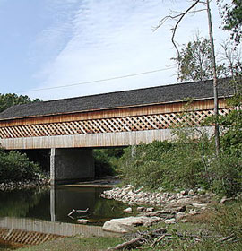
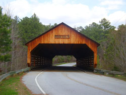 This covered bridge, formerly known as Haralson Mill Bridge, was built in 1997 by APAC over Mill Rock Creek in Rockdale County.