Visit Rabun County Parks - Check out the Bartram Trail, Dick's Creek Falls, Becky Branch Falls, Chattooga Wild and Scenic River in the Chattahoochee National Forest, Lake Rabun, Lake Burton, Lake Seed, Popcorn Overlook and more. Stay and Play in Georgia!
Bartram Trail - Amenities: 37-mile portion of the Bartram National Recreation Trail in the Tallulah Ranger District of the Chattahoochee National Forest. Open 24/7. Phone:
706-782-3320 - Location: Clayton, GA 30525 - Off of Hwy 246 north of Dillard
Becky Branch Falls in the Chattahoochee National Forest - Amenities: Waterfalls with 20-ft cascade. Phone: 706-782-3320 - Location: Warwoman Road, Clayton, GA 30525 - Directions: It is located 5 minutes from downtown Clayton and is easily accessible. From Clayton, drive east on Warwoman Road for 2.8 miles and park of left side of road by branch. Walk up the right side of branch on the trail for about 200 yards to a bridge at base of falls.
Black Rock Mountain State Park - Amenities: 1743 acres in size. Highest mountain in Georgia State Park with an altitude up to 3640 feet. 48 tent, RV and trailer sites, pioneer campground, 12 walk-in sites, 4 backcountry campsites, 10 cottages with dog friendly cottages, 2 picnic shelters, 17-acre lake which has bass, bream, catfish, perch and trout fish, visitor center, 11 miles of hiking trails, and numerous scenic overlooks with streams, waterfalls and lush forests.
Chattooga Wild and Scenic River in the Chattahoochee National Forest - Amenities: One of the longest free-flowing rivers in the southeastern United States that is still relatively primitive and undeveloped. The Chattooga has been named to the prestigious Wild and Scenic River System. Located in extreme northeast Georgia, the Chattooga for 40 miles also servs as the boundary between Georgia and Southe Carolina. Kayak enthusiasts may be seen shooting the whitewater during the summer months. Commercial outfitters, with proper equipment, conduct rafting trips for experiencd and novice floaters. Hiking, fishing, kayaking, and rafting. Phone: 706-782-3320 - Location: US Highway 76 East, Clayton, GA 30525
Coleman River Scenic Area in the Chattahoochee National Forest - Amenities: Hikers on the Coleman River Trail follows a path that parallels the river for 1 mile through stands of large old-growth timber growing alongside a stream tumbling through high boulders. Hiking trails meander though old-growth timber alongside a stream tumbling through high bolders. Open: Daily. Phone: 770-782-3320 Address: FS Rd. #70, Clayton, GA 30525 - Directions: US Hwy 76 W for 8 mi; turn R (N) on paved county road for 4 mi; turn L (NW) on FS Rd 70 for 1.25 mi.
Dick's Creek Falls in the Chattahoochee National Forest - Amenities: A beautiful 60 foot fall that makes a sudden drop into a granite mound into the Chattooga Wild and Scenic River. Open daily. Phone: 706-782-3320 - Location: Off Dick's Creek/Sandy Ford Road, Clayton, GA 30525 - Directions: Off Sandy Ford Road From Hwy 441/ Warwoman Road intersection in Clayton, take Warwoman Road east for 5.9 miles to Sandy Ford Road on the right. Travel 0.6 miles bearing left at the fork. Travel 3.4 miles to the second ford. Cross the creek and proceed to the Bartram Trail marker at the top of the hill.
Holcomb Creek Falls in the Chattahoochee National Forest - Amenities: It has a hiking trail passes Holcomb Creek Falls which drops and flows over the shoals for approximately 150 feet and Ammons Creek Falls and it's observation deck. Open: Daily. Phone: 706-782-3320 - Location: Off Warwoman Road, Clayton, GA 30525 - Directions: Warwoman Road to Hale Ridge Road from Clayton.
Lake Burton - Amenities: A 2,775 acres Georgia Power Lake with 62 miles of shoreline. Boating, camping, picknicking, swimming and fishing. Phone: Toll Free - 888-GPCLAKE or 706-782-4014 - Location: GA Hwy 197/US Hwy 76, Clayton, GA 30525 Directions: GA Hwy 197 N from Clarkesville.
Lake Seed - Amenities: A Georgia Power Lake. With 13 miles of shoreline, it has many recreational opportunities to offer. This 240-acre lake features swimming, boating, fishing, and primitive camping at Seed Campground. 1,724.5 feet above sea level. Phone: Toll Free - 888-GPCLAKE or 706-782-4014 - Location: Crow Creek Rd off Burton Dam Rd, Lakemont, GA 30552 - Directions: Burton Dam Rd to Crow Creek Rd.
Lake Rabun - Amenities: An 835-acre Georgia Power lake with 25 miles of shoreline. Boating, fishing, public beach, camping and lodging. Open Year round. Phone: Toll free - 888-GPCLAKE or 706-782-4014 - Location: Lake Rabun Road, Lakemont, GA 30552 - Directions: US 441 north.
Moccasin Creek State Park - Amenities: 32 acres in Blue Ridge Mountains area. 55 tent, RV and trailer campsites, picnic shelter, playground, 2800-acre Lake Burton, boat dock and ramp, wheelchair accessible fishing pier, seasonal canoe and Jon boat rental, trout rearing station, lake fishing for bass, crappie and bream, stream fishing for trout, 1-mile non-game interpretive trail with wildlife observation tower and 2 miles of Hemlock Falls hiking trails with waterfall in trail.
Popcorn Overlook- Amenities: located in the Chattooga Ranger District, this scenic vista overlooks the mountains along US 76 west of Clayton. Picnic tables, benches and car stops made from recycled plastic and wood fiber are used here. Picnicking. Phone: 706-782-3320 Location: US Hwy 76 West, Clayton, GA 30525 - Directions: Take US Hwy 76 W of Clayton for 12 miles.
Rabun Beach Recreation Area Activity Overview in the Chattahoochee National Forest- Amenities: Overlooks beautiful Lake Rabun and the north Georgia mountains. This recreation area offers camping, hiking, swimming, boating and fishing. Eighty tent and trailer campsites are available, some with electrical and water hookups. Hikers can enjoy the 1.3-mile Rabun Beach Trail, which ends at Angel Falls. The swim area has eight picnic tables, a roped-off area for swimmers, and restrooms. A boat launch area is near the swimming area. Lake Rabun is home to bass, bream, perch, trout and catfish. Note: Check State regulations before you fish. A paved road leads through the recreation area. Sites have a grill, picnic table, lantern post, and tent pad. Hot showers, drinking water, and dump station are also available. Phone: 706-782-3320 - Location: Lake Rabun Road South (Country Rd. 10), Clayton, GA 30525 Directions: GA Hwy 15 for 2 miles; turn R on County Road 10 for 5 miles.
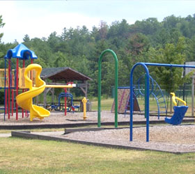
Rabun County Recreation Park- Amenities: 9 baseball-softball fields, 2 gyms, a multi-purpose field for football and soccer, picnic pavilions, olympic size outdoor swimming pool, riding ring for horses, and a playground designed for children ages 2-5 and one for children ages 5-12. The playgrounds have a covered pavilion which makes it perfect for birthday parties or cook-outs. Phone: 706-782-4600 - Address: 400 Rabun Park Drive, Tiger, GA 30576
Sandy Bottoms Campground in the Chattahoochee National Forest - Amenities: This recreation area has good trout fishing and rugged mountain scenery. Picnicking and fishing. Located in the Tallulah Ranger District. Phone: 706-782-3320 - Address: FS Road #70, Clayton, GA 30525 - Directions: US Hwy 76 W for 8 mi; turn R(N) on county road for 4 mi; turn L(NE) on FS Rd #70 for 5 mi.
Southern Nantahala Wilderness in the Chattahoochee National Forest Amenities: Hiking, backpacking, climbing, kayaking, canoeing, rafting, horse packing, bird watching, stargazing, and extraordinary opportunities for solitude. Open: Daily Phone: 706-782-3320 - Location: Tallulah River Road (FS Road #70), Clayton, GA 30525
Tallulah Gorge State Park - Amenities: 2689 acres.
One of the most spectacular canyons in the eastern U.S., Tallulah Gorge is 2 miles long and nearly 1,000 feet deep. 50 tent, RV and trailer campsites operated by Georgia Power, primitive campground, backcountry Adirondack shelter, 2 picnic shelters, Jane Hurt Yarn Interpretive Center, gorge overlooks, suspension bridge, tennis courts, 63-acre lake with beach, seasonal - swimming, fishing, 20 miles of nature hiking and mountain bicycle trails, Bicycling – 1.7-mile paved “Rails to Trails” path. Hours are 7 am - 10 pm
- $5 Parking Fee.
Tallulah River Campground in the Chattahoochee National Forest- Amenities: A rugged mountain scenery and the Tallulah River plunging by make this a beautiful place to camp, fish or hike. Phone: 706-782-3320 - Address: FS Road 70, Clayton, GA United States 30525 Directions: Take U.S. 76 west from Clayton for 8 miles; turn right (north) on unnumbered paved county road for 4 miles; turn left (northwest) on Forest Service Road 70 for 1 mile.
Tate Branch Recreation Area in the Chattahoochee National Forest - Amenities: This recreation area has good trout fishing, exceptional fall color and remote mountain scenery. Camping, fishing and hiking. This remote area offers 19 camp sites with tent pads, picnic tables and grills. Trout fishing is good along the Tallulah River and Tate Branch. Check State fishing regulations before fishing. Hiking through nearby Coleman River Scenic Area is popular. The Coleman River Trail parallels the river for 1 mile through stands of large old-growth timber. Clayton, Tallulah Falls and Hiawassee are interesting towns to visit. The Southern Nantahala Wilderness, Chattooga Wild and Scenic River and the Appalachian Trail are nearby.
Good, hard-surface roads until you reach Forest Service Road 70; expect narrow gravel road that is crooked and steep in parts. Each of the 19 campsites are equipped with a tent pad, picnic table and grill. Drinking water is also available at this area. A fee is required. Open 24/7, year long. Phone: 706-782-3320 - Address: FS Road #70, Clayton, GA 30525 - Directions:US Hwy 76 W for 8 mi; turn R(N) on country road for 4 mis; turn L(NW) on FS Road #70 for 4 mi.
Terrora Park- Amenities: A day use park with fishing, lakeside picnic, nature trails, playground, pavilion, tennis, and seasonal swimming with lifeguards. Phone: 706-782-4014 - Hwy. 441, Tallulah Falls, GA.
Willis Knob Horse Campground in the Chattahoochee National Forest- Amenities: Horse camps and horse trails are available at this recreation area near the South Carolina state line.
Rugged mountain scenery over trail that descends into the Chattooga River basin. Camping, fishing, hiking, and horse trails. This trail provides some of the most scenic horseback riding opportunities in the Southeast. it features both rugged mountain terrain and views of the Chattooga Wild and Scenic River. Open: 24/7 Year round. Phone: 706-782-3320 Location: Willis Knob Road, Clayton, GA 30525. Directions: Warwoman Rd E for 11.6 mi. Turn R on Goldmine Rd. Look for Woodall Ridge Day Use Parking Area signs