NPS Appalachian National Scenic Trail in Georgia - "The body of the Trail is provided by the lands it traverses, and its soul is in the living stewardship of the volunteers and workers of the Appalachian Trail community." - from the Appalachian Trail Management Principles-A.T. Comprehensive Plan.
Trail History and Description
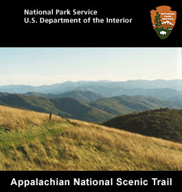
Appalachian Trail has a wilderness public footpath that extends from Georgia to Maine and winds through scenic, wooded, pastoral and culturally resonant lands across 2,155 miles of Appalachian Mountain ridgelines. Primarily used for day hikes, adventurers have been known to pack the entire route.
This trail in GA extends some 75 miles through the primitive areas of the Chattahoochee National Forest. Although rising at times to elevations of over 4,000 feet, the Trail is mostly along ridges at elevations of about 3,000 feet. It offers unlimited hiking adventure of exceptional challenge and variety. Ascents and descents are sometimes steep, but are often rewarded by scenic vistas from rocky outcrops and open summits. A series of white blazes, trail marking, indicate the Appalachian Trail while blue blazes designate side trails and trails to water. Along the way, the hiker will find shelters for camping.
The Trail's southern terminus is located atop remote Springer Mountain, near Forest Service Road 42. Since this area is difficult to reach by automobile, an 8.8 mile blue blazed "approach trail " begins at Amicalola Falls State Park on GA 52. Outstanding peaks along the Trail include Big Cedar Mountain, Blood Mountain, Cowrock Mountain, Rocky Mountain, and Tray Mountain. One of the many side trails leads from Chattahoochee Gap to the highest point in Georgia, Brasstown Bald. Bly Gap on the Georgia/North Carolina border is the northern end of the AT in Georgia.
The Georgia Trail is managed and maintained by the Georgia Appalachian Trail Club through a cooperative agreement with the U.S. Forest Service, Chattahoochee National Forest.
The southern Appalachian Mountains are ancient mountains. Once as tall and rugged as the Alps, these ancient mountains have been changed by the hand of geologic time. Today they are cloaked in a dense mantel of diverse vegetation; oak, hickory, and hemlock; rhododendron, laurel, wildflowers and ferns. These mountains are home to the bear, turkey, and salamander.
The Appalachian Trail (A.T.) is more than 2,175-mile long footpath stretching through 14 eastern states from Maine to Georgia. Conceived in 1921 and first completed in 1937, it traverses the wild, scenic, wooded, pastoral, and culturally significant lands of the Appalachian Mountains.
The A.T. Hiking Trail is enjoyed by an estimated 4 million people each year. It is within a day's drive of 2/3rds of the U.S. population. People of all ages and abilities enjoy short walks, day hikes, and long-distance backpacking journeys. It offers a variety of opportunities for viewing spectacular scenery, for exploring, for adventure, for exercise, for nature study, and for renewal.
Operating Hours & Seasons
In general, the A.T. is open continuouly year-round. The northern terminus at Katahdin is within Baxter State Park, which may be closed in winter months, depending on weather conditions. Particular sections of the Trail, and less-developed roads accessing the Trail, may be closed temporarily for a number of reasons. Detailed information is available from the Appalachian Trail Conservancy.
Fees & Reservations
You do not need a permit to walk the A.T., but overnight camping permits are required in some areas. There are no fees required to hike the A.T., and generally, no reservations are required or accepted at trail shelters or overnight sites. However, there are fees for vehicle parking in some areas and there are fees at some overnight sites. Specific information is available from ATC.
Directions to Trail
Getting to the Appalachian Trail by Car
More than 500 public roads cross the Appalachian Trail, and there are trailhead parking areas at or near many of these crossings. The map of the A.T. provides information on the location of the Trail. More detailed information, including maps and trail guidebooks, is available from ATC at (304) 535-6331 or www.appalachiantrail.org. Open: Year round
More Contact Info -
Phone: 706-635-7400
Interesting Appalachian Trail Facts
The total length of the Appalachian Trail is more than 2,175 miles. The Trail was designed, constructed, and marked in the 1920's and 1930's by volunteer hiking clubs brought together by the volunteer-based, nonprofit Appalachian Trail Conservancy (ATC).
Approximately three to four million visitors hike a section of the Appalachian National Scenic Trail each year.
Threats from commercial development and concern for recreational opportunities prompted Congress to pass the National Trails System Act in 1968. The Appalachian National Scenic Trail was the first trail to fall under this new act.
The Appalachian Trail evolved from the 1921 proposals of Massachusetts regional planner Benton MacKaye to preserve the Appalachian crests as a wilderness belt - a retreat from urban life. The Appalachian Trail Conservancy was formed in 1925 and focused on the hiking aspect of MacKaye's vision.
More than 6,000 individual volunteers contribute more than 195,000 hours each year towards the protection, maintenance, and promotion of the Appalachian Trail.