|
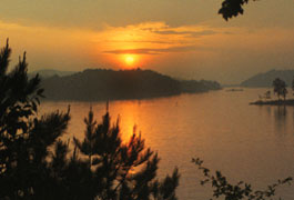
 It embraces a spectacular tract of foothills scenery in the North GA Blue Ridge Mountains. Its sparkling waters and rugged shoreline provide a wonderful surrounding for a variety of fun recreation. It embraces a spectacular tract of foothills scenery in the North GA Blue Ridge Mountains. Its sparkling waters and rugged shoreline provide a wonderful surrounding for a variety of fun recreation.
General Info: Located between Calhoun and Ellijay on the Coosawattee River, Carters Lake is about a two-hour drive from Atlanta.
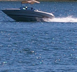
Carters Lake is popular for camping, fishing, picnicking, boating, mountain biking and hunting activities Carters Lake has 3200 surface acres. Carters Lake is more than 450 feet deep. Carters Dam is the tallest earthen dam east of Mississippi river. Carters Lake 62 miles of natural shoreline has no private docks or development. The lake is named after Farrish Carter who owned property nearby in the 1800's.
U.S. Army Corps of Engineers lake, beach and dam info: 706-334-2248 Lake level info: 706-334-2906 Lake level info: 706-334-2906
Mailing Address: Carters Project, P.O. Box 96, Oakman GA 30732 |
| Camping Info |
Boat-In - Hike-In Campground - Open Year-round
Campground Info: Boat-in/Hike-in camping provides 12 primitive campsites with tables, tent pads, lantern holders and trash cans. Campsites are free and available year-round on a first-come-first-serve basis. There are primitive toilets but no drinking water. Boaters can tie up near their site and enjoy a waterfront site in a beautiful setting. Campers can also hike to sites along a newly constructed Amadahy Trail that begins at the barricade on the Woodring Branch access road. Distance to the campground from the trail head is approximately two miles one way.
Location: The campground is located on a peninsula east of Carters Dam. |
|
Doll Mountain Campground - 706-276-4413 - Season Dates: Opens first Friday in April and closes the last Saturday in October.
Campground Info: 65 campsites. 39 sites have electrical and water hookups, 4 of the electric and water sites also have sewer, the remaining 26 sites are tent only sites. Facilities include: comfort stations with hot showers and coin laundry, boat ramp with dock, playground, pay phone, accessible restroom, basketball, dump station, amphitheater, and an attendant on duty. Call for camping fees.
Alerts and Important Information
Reservations must be made at least 2 days in advance. This campground requires a 2 night minimum stay on weekends. This campground requires a 3 night minimum stay on holiday weekends. Campground hours are 9 am until 10 pm. Vehicles may exit via an electronic gate. No vehicles will be permitted in the campground after 10pm. Attendants are on duty. Park access road has a steep downhill grade, campers should use caution when entering the area.
Location: Doll Mountain Campground is located approximately three miles off Hwy 382 on the south side of the lake. Doll Mountain Campground Brochure and Map |
Harris Branch Campground - 706-276-4545 - Season Dates: Early May through early Sept.
Campground Info: 10 primitive sites. Individual campsites are available on a first come first serve basis only (no reservations). Facilities at Harris Branch include: comfort station with hot showers and coin laundry, playground, pay phone, and an attendant on duty. Other facilities at Harris Branch include a group camping area and a public beach.
Location: Harris Branch Campground is located approximately three miles off Hwy 382 on the south side of the lake. Harris Branch Campground Brochure and Map |
Ridgeway Campground - Open Year-round
Campground Info: 25 primitive sites with tables, tent pads, lantern holders and trash cans. Sites are not located near the lake, but campers can utilize the boat ramp in the park to launch boats. Water is provided (hand pump) and waterless toilets are also located in the campground. The park is open year-round. Call 706-334-2248 for prices (pay at the self-deposit fee vault). |
|
Woodring Branch Campground - 706-276-6050 - Season Dates: Early April to end of Oct.
Campground Info: Primitive Campground open year-round. 42 campsites, 31 have electrical and water hookups, and 11 sites are tent sites. Facilities and Amenities Include: comfort station with hot showers and coin laundry, boat ramp with dock, playground, pay phone, dump station, amphitheater, and an attendant on duty. Some campsites have hookups and some don't. Woodring Branch also has a separate primitive camping area with twelve sites. Call for camping fees. Check out the Amahady bike trail.
Location: Woodring Branch Campground is located approximately four miles off Hwy 282 on the north side of the lake. Woodring Branch Campground Brochure and Map |
| More Reservation Information for all Carters Lake Campgrounds |
Camping reservations can be made up to 240 days in advance at: Recreation.gov or call
877-444-6777 or by phoning individual campgrounds directly during the camping season. Harris Branch group camping reservations phone 706-276-4545 May-September only.
Annual Day Use Pass Program - The annual day use pass is a hangtag which can be moved from vehicle to vehicle. The pass is valid for 12 months from the month of sale. For example, an annual day use pass purchased any day in April 2008 will be valid until April 30, 2009. An annual day use pass decal is available for open vehicle such as motorcycles and jeeps. Duplicate annual day use passes are no longer sold because the annual day use pass hangtag can be moved from vehicle to vehicle.
America the Beautiful Senior Pass, America the Beautiful Access Pass, Golden Age Pass and Golden Access Pass holders will still receive a 50 percent discount on the purchase of one annual pass; however, the holder must be an occupant of the vehicle that uses the annual day use pass. Call 678-721-6700 for more information and to purchase a park pass. |
|
|
|
Check these out:

Fishing at Carters Lake
Carters Lake Map
Carters Lake Vicinity Map

Georgia Lakes
WMA Public Fishing Areas
GA Fishing Lakes
Georgia Rivers & Map
GA Lakes & Rivers Map
Water Safety
|