|
Take a journey through the Nature Trail and Marsh Walk and discover the wonders of our natural surroundings. No admission charge and this trail is open during daylight hours. As you enter the nature trail, there is a sign on the left describing the marsh rabbit.
This species is the most commonly observed mammal in the trail area. Often, during the early morning or late afternoon hours, rabbits may be seen feeding in the grassy areas adjacent to the wooded areas. They hide or rest in the more woody or thickly bushed areas during the middle of the day, and may be observed darting from one thicket to another.
Students should walk quietly to increase their chances for observing rabbits and other wildlife species in the area.
The first boardwalk crosses over an area populated by a woody saltwater marsh plant call sea oxeye. This saltwater tolerant plant produces a yellow flower with a brown sticky center that apparently reminded people of an eye of a ox. The sea oxeye is important to the salt marsh ecosystem by stabilizing the upper reaches of the high tide zone.
Typically, only the spring tides (new and full moon periods)
inundate the elevation where sea oxeye grows (and out competes other salt marsh plants).
Just before leaving the first boardwalk, one can observe the light green leaf cedars known as oriental tamarisk growing along the fringes of the hammocks. The oriental tamarisk is not native to Georgia, but rather Southeast Asia. It was most likely introduced accidentally to this area by cargo ships. |
|
|
As you enter the first picnic area, to the right is a large sugarberry tree, also known as a hackberry tree. This tree is known for its strange looking cork-like bark.
Many different
birds eat the berries produced on this tree.
 Located to the right of the first picnic area is a bird house, feeder display and an information Located to the right of the first picnic area is a bird house, feeder display and an information
shelter. The birdhouse and feeder display allow students to compare various birdhouse designs as well as feeders for different types of birds and feed. Blueprints for building birdhouses are available at the aquarium display in the DNR office building.
The information shelter provides a wide range of information on local estuarine plants
and animals.
To the left of the first picnic area is the trail leading to the Osprey Observation Platform. From this observation deck, the osprey nesting tower can be observed. When coastal Georgia was being developed and settled, most of the large timber along the coast was cut and shipped to New England and Europe.
Unfortunately, these large trees were needed for nesting ospreys. Considering that very few of the large trees are left and that it will take hundreds of years for young trees to grow to large size, DNR constructs artificial nesting trees for ospreys and eagles.
Ospreys are most typically observed at
the nest during early spring. They are fish eaters and capture their prey by swooping down and snatching the fish from the water surface.
Behind the Osprey Observation Platform, prickly pear cactus may be observed. It is one of the native foods that Indians ate in coastal Georgia. Its purple pod is edible and can be made into jams or preserves. The Indians would also remove the thorns and slice up the broad leaves and cook them. |
|
|
When returning to the first picnic area, take the South Loop trail. Portions of this trail are located
at the fringe area between the low salt marsh plants and the higher ground with more woody
plants. Along the way, observe the sign identifying the wax myrtle.
 Early colonists made candles from
this plant. Farther along the South Loop, observe the cabbage palm tree. The bud or base of the leaf core is edible. Indians and colonists used this portion of the plant in much the way vegetable salads are prepared today. Early colonists made candles from
this plant. Farther along the South Loop, observe the cabbage palm tree. The bud or base of the leaf core is edible. Indians and colonists used this portion of the plant in much the way vegetable salads are prepared today.
The South Loop passes by the Sand Flat Observation Platform that is located adjacent to a sand flat. Notice the lack of marsh grass growth on the sand flat. As tidal waters recede, the saltwater remaining on the flats evaporates very quickly leaving a high salt content level.
The high
concentration of salt inhibits plant growth. Wading birds such as the willet, glossy ibis and wood stork may be observed in this area.
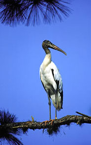
The wood stork is the only true native stork in North America. Although it nests chiefly in cypress swamps, it often feeds in salt marsh areas. In recent ars,
their numbers have declined drastically due to land development, lumbering and draining of their breeding and feeding grounds. The wood stork is presently classified endangered species.
A
plant or animal may be classified as an “Endangered species” when it is in danger of extinction throughout all or a significant portion of its range. |
|
|
Continue on the South Loop to the second picnic area.
Located to the left of the bridge is a
mulberry tree. This tree is very abundant throughout the nature trail. The small fruit
produced in late spring is eaten by wildlife and
was a food of Native Americans.
Indians also
wove cloaks from the fibrous inner bark of young mulberry shoots.
Located to the right of the bridge
entrance is a sign showing the more common wading birds in the area. Also, note the sign illustrating various animal tracks that may be observed along the water's edge. |
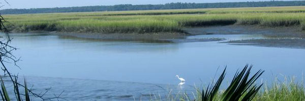
 The bridge crosses a marsh and tidal pond area that was once high ground connecting the
two hammocks. The bridge crosses a marsh and tidal pond area that was once high ground connecting the
two hammocks.
When DNR purchased this
property from the City of Brunswick, DNR assumed the responsibility of mitigating, or replacing, marsh that was destroyed when the City was developing the area. Therefore, DNR was required to create 2.4 acres of marsh for the 1.2 acres filled by the City. The area the bridge crosses is a portion of the mitigation site.
From the bridge, observe how the new growth of marsh is spreading throughout the mitigated
area. Eventually, marsh will cover most of the ground exposed during low tide. The broad bladed
grass which dominates the mitigated area is smooth cordgrass.
In addition, patches of saltwort
and sea oxeye are developing throughout the tidal pond area. The most often observed white wading birds seen feeding on small fish in the tidal pond are the snowy and great egrets.
The smaller of the two, standing about two feet high, is the snowy egret. The snowy is often called “golden slippers” for its yellow feet and black legs. The great egret stands about three feet high and may be distinguished by having black feet and legs. |
|
By far the most numerous of the animals generally occurring in the sand flat area are fiddler
crabs. Two species of fiddler crabs occur in this area, the sand fiddler and mud fiddler.
 As their names suggest, the sand fiddler crab generally
inhabits the more sandy sediments of the flats whereas iddler crab generally occurs in marshy mud areas. The carapace of the sand fiddler is whitest with conspicuous pink and purple patches. The carapace of the mud fiddler is brown. As their names suggest, the sand fiddler crab generally
inhabits the more sandy sediments of the flats whereas iddler crab generally occurs in marshy mud areas. The carapace of the sand fiddler is whitest with conspicuous pink and purple patches. The carapace of the mud fiddler is brown.
To observe the fiddler crab, locate an area with many burrows, remain still several feet away
until the fiddlers feel safe and emerge. They live in tiny burrows and scurry about feeding on algae and nutrient-rich marsh mud.
Curiously, the male fiddler crab has one small claw and one big claw that is almost as large as the rest of his body. He can feed only with his small claw. The large claw is used for defense and, by waving it in the air, to attract a female. Females have two small claws.
Often, large numbers of mud minnows and striped mullet may be observed in the pond. Occasionally, a blue crab may be observed feeding along the pond's edge or you may see the head of a diamondback terrapin lazily floating at the surface. |
At the north end of the bridge is the trail's third picnic area. To the left is a red cedar tree.
The eastern red cedar is actually a juniper, and not a
true cedar. Birds use its stringy bark as nest material. Its evergreen foliage provides year-round cover for many wildlife species. Its berrylike fruit is also an important food source for many birds. |
To the left of the bridge is the North Loop portion of the Nature Trail. Although signage for the black crown night heron, marsh elder and few tree species such as the black cherry and Carolina cherry laurel (unmarked) are located on this portion of the trail, limited new plants and animals may be observed on the North Loop.
The
North Loop is approximately 260 feet in length allowing students to spread out more throughout the trail system.
If time is a limiting factor, the trail to the right of the third picnic area leads to the Observation Tower.
Either trail will pass by a yaupon tree. Yaupon is an evergreen holly that produces red berries in the fall that are a popular food for many songbirds. Native Americans made a tea called “the black drink” from leaves of this tree. The drink caused vomiting and purged their bodies before long journeys or battle. |
 The Observation Tower measures 12 x 16 feet and is approximately 20 feet high. The Observation Tower measures 12 x 16 feet and is approximately 20 feet high.
The upper deck of the tower provides a vista of the St. Simons
Sound. The wide expanse of marsh grass lying before the tower is predominately smooth cordgrass. It has a thick stalk with long tapering leaf blades and grows as high as 6 feet.
There are several major barrier islands visible from the Observation Tower. To the left toward the horizon is St. Simons Island with Jekyll Island to the right. The gap between these islands is the St. Simons Sound and the Atlantic Ocean beyond. The small island to the far right across Plantation Creek is Quarantine Island.
During the 1800's, this island was used as a place of quarantine for sick sailors to remain while their sailing ship was loading or unloading cargo at the Brunswick Port. A doctor out of Brunswick would meet the incoming ships and check the ship's crew for illnesses. With very few medicines available during that time, quarantines greatly reduced the chance of a disease outbreak brought in by ships. |
|
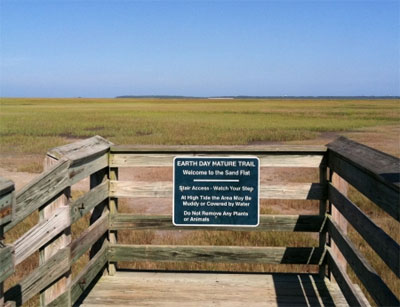
The lower level of the tower leads to the sand flat boardwalk. This is a good area to note the
change in vegetation from high ground to smooth cordgrass. There are many signs on the
boardwalk to help identify plants and animals that may be observed from the boardwalk. Steps at the end of the boardwalk allow access to the sand flats and salt marsh. |
| Sand Flat and Marsh Walk |
| The Marsh Walk portion of the Nature Trail begins at the steps of the tower boardwalk. Although nature trail rules state “Do Not Disturb Plants and Animals,” students are allowed to examine plants and animals in the marsh walk area, but should not unnecessarily harm any plant or animal or take plants and animals from the area. |
Upon entering the salt flat area, note the slight variations in elevation and the effect these
changes have on the occurrence of different plant species.
A slight increase of the sand flat in elevation creates suitable habitat for saltwort or possibly salt grass while higher elevations may
yield sea oxeye. The saltwort has a green to pink thick stem and virtually microscopic leaves. Pick some and “enjoy” the little stems. These stems may be included in green salads or stuffed crab.
A slight decrease in the sand flat elevation may create a tide pool or habitat suitable for cordgrass. Although the salt marsh may consist of many plant species, cordgrass is the great producer of the salt marsh. Cordgrass occupies the lower level of the marsh that receives water and minerals twice daily as tides rise and flood the marsh. |
In addition to plants, many animals or their signs (i.e. tracks, burrows, empty shells) may be detected in the sand flat area.
A host of wading birds, such as the great egret, wood stork, Ibis, willet, and a variety of herons feed on the flats and in the salt marsh. Although not as obvious due to its secretive nature, and perhaps more spectacular, is the clapper rail.
Often clapper rails can be heard calling to each other with their distinctive clapping sound call (kek, kek, kek, kek, kek). |
When first entering the marsh, a strong odor may have been detectable. It may smell bad at first, but it shouldn't be offensive considering it is caused by the richness of the marsh mud.
Since the marsh is regularly covered with tidal water the organic material in the mud can only be decomposed by anaerobic bacteria (bacteria that do not utilize oxygen). Part of the order is hydrogen sulfide produced as a byproduct of these types of bacteria. |
| Another source of strong smells is blue green algae. Scrape the base of a cordgrass stalk and sniff the green slime collected. This primitive plant has the ability to change atmospheric nitrogen into forms that cordgrass and other plants can use. |
A common resident of the salt marsh is the marsh periwinkle. The shell of the periwinkle is grayish white and measures up to 1.25 inches in length. They may be found on cordgrass leaves or crawling in the mud feeding on detritus.
Another snail frequently observed feeding at the base of cordgrass and the mud surface is the mud snail. The dull black shell of the mud snail measures up to one inch in length. |
| To locate the ribbed mussel, examine the sediment at the base of cordgrass in muddy marsh areas. Often, ribbed mussels may be found partially buried, held in place by their root-like holdfast. Mussels are filter feeders filtering the tidal flood waters to gather protozoa and detritus for its food. The ribbed shells of these mussels may grow up to 5 inches in length. |
| A direct food chain is involved in the salt marsh. The cordgrass traps radiant energy from the sun and converts it into organic matter. Bacteria and fungi decompose the cordgrass, protozoa feed on the bacteria, fiddlers feed on the protozoa and rails feed on fiddlers. When a hunter or predator eats a rail, he derives energy from cordgrass and ultimately the sun. |
| A far more important human food source is produced by a similar food chain. Found in the small meandering marsh creeks in and around the nature trail are tremendous numbers of tiny aquatic creatures. There are dozens of species of microscopic “seafood” forms in these shallow, protected nutrientrich streams. The “fry” or young of shrimp, crabs, and fish, though usually hatched at sea, use the salt marsh as a nursery ground for a portion if not all of the life span. Most shrimp, crabs, and marine finfish purchased at local seafood markets spent their early life in a salt marsh stream. |
| When students have seen most of these things in the coastal salt marshes, they will have observed one of the most productive ecosystems known to man. Hopefully, the students will leave the Nature Trail with the conviction that it is a part of their life support system and that they will help conserve every inch of the salt marshes. |
| Nature Trail Rules |
 No Smoking No Fires No Pets No Alcoholic Beverages Leave Only Your Foot Prints No Smoking No Fires No Pets No Alcoholic Beverages Leave Only Your Foot Prints
Do Not Disturb Plants and Animals Open Daily During Daylight Hours |
| Reservation Information - Use of the center must be scheduled in advance by contacting DNR Coastal Resources Division (CRD) at (912) 264-7218 |
| Contact and Address |
Phone: (912) 264-7218 - Fax (912) 262-3143 - Address: One Conservation Way, Brunswick Georgia 31520 - Glynn County - Directions I-95 S to Exit 29; Hwy 17 N to Conservation Way, on N end of Sidney Lanier Bridge. Park at GA Dept of Natural Resources (DNR). |
| Website Resources |
| Coastal Resources Division |
|